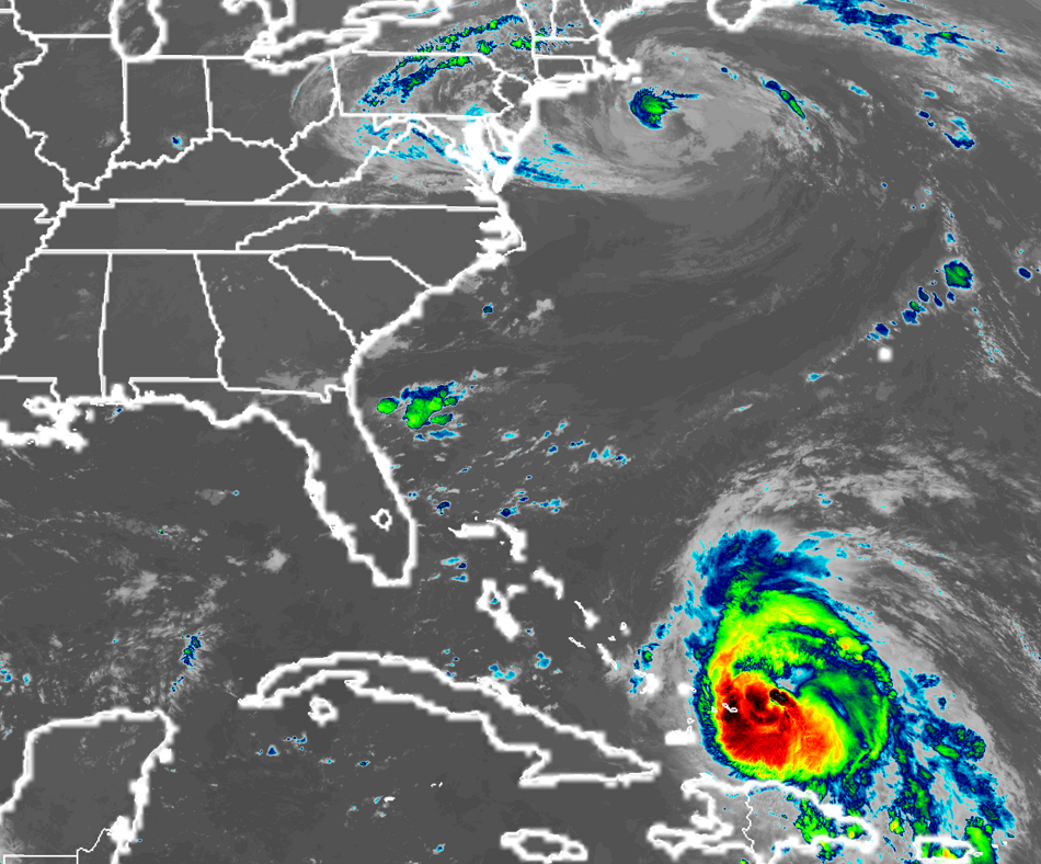
Hurricane Maria continues to lash the Bahamas today, bringing serious impacts to the Turks and Caicos just a short time after Hurricane Irma devastated the islands. Maria is forecast to continue to impact the area this weekend as it makes it way up the East Coast. It is still too early to say with certainty whether Maria will move out to sea or to land with time.
With Hurricane Maria continuing to impact the Caribbean, a variety of watches and warnings remain in effect.
Hurricane Warnings are up for the Dominican Republic from Cabo Engano to Puerto Plata and for the Turks and Caicos Islands and the southeastern Bahamas. A Tropical Storm Warning is in effect for the Dominican Republic west of Puerto Plata to the northern border of the Dominican Republic and Haiti. A Tropical Storm Warning is also in effect for the central Bahamas. A Hurricane Warning means that hurricane conditions are expected somewhere within the warning area. Preparations to protect life and property should be rushed to completion.
A Tropical Storm Warning means that tropical storm conditions are expected somewhere within the warning area.
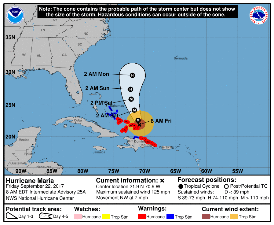
At 8am this morning, the center of Hurricane Maria was located near latitude 21.9 North, longitude 70.9 West. Maria is moving toward the northwest near 7 mph, and a motion toward the north-northwest is expected later today and Saturday. On the forecast track, Maria’s eye will move near or just east of the Turks and Caicos Islands and southeastern Bahamas today. Maximum sustained winds are near 125 mph with higher gusts. Maria is a category 3 hurricane on the Saffir-Simpson Hurricane Wind Scale. A gradual weakening is forecast during the next 48 hours. Hurricane-force winds extend outward up to 70 miles (110 km) from the center, and tropical-storm-force winds extend outward up to 160 miles. The minimum central pressure based on data from an Air Force Reserve Hurricane Hunter aircraft is 959 mb (28.32 inches).
Numerous hazards continue to impact the region:
WIND: Tropical storm conditions across portions of the Dominican Republic should subside during the next several hours. Hurricane conditions are spreading into the Turks and Caicos Islands and the southeastern Bahamas and will continue through today. Tropical storm conditions are expected in the central Bahamas beginning tonight.
STORM SURGE: A dangerous storm surge accompanied by large and destructive waves will raise water levels by as much as 9 to 12 feet above normal tide levels within the hurricane warning area of the southeastern Bahamas and the Turks and Caicos Islands.
RAINFALL: Maria is expected to produce extremely heavy rain through Saturday:
Turks and Caicos: 8-16″, isolated 20″ amounts
Puerto Rico: additional 3-6″, isolated maximum storm total amounts 40″
Eastern Dominican Republic: additional 4 -8″, isolated storm total amounts 20″
Western Dominican Republic and northern Haiti: additional 3-6″
Mayaguana, southeast Bahamas: 4-8″
Inagua Islands and Crooked Island, Bahamas: 2-6″
Rest of eastern Bahamas: 1-3″
Rainfall on these islands will continue to cause life-threatening flash floods and mudslides.
SURF: Swells generated by Maria are affecting Puerto Rico, the Virgin Islands, the northern coast of Hispaniola, the Turks and Caicos Islands, and the southeastern Bahamas. These swells will reach the remainder of the Bahamas soon and should reach portions of the United States southeastern coast today. These swells are likely to cause life-threatening surf and rip current conditions.
