Hurricane Nicole made landfall early this morning at around 3 am just south of Vero Beach, Florida, and has weakened considerably since. Downgraded to a tropical storm, the remnants of what was once Hurricane Nicole will continue to spread north, bringing wind-whipped rains to much of the eastern United States. As is the case with most landfalling tropical cyclones, there will also be an expanding area at risk for isolated tornadoes on the eastern side of the storm system.
As of the latest advisory from the National Hurricane Center, Nicole was a tropical storm located in Florida about 45 miles north of Tampa and 165 miles southeast of Tallahassee. Maximum sustained winds were down to 45 mph while minimum central pressure was up to 988 mb or 29.18″. The storm was moving to the northwest at 15 mph. A turn
toward the north-northwest is expected later this afternoon, followed by a turn toward the north tonight. Nicole is expected to accelerate north-northeastward on Friday. On the forecast track, the center of Nicole will move over the far northeastern Gulf of Mexico in the next several hours and then move inland over the eastern Florida Panhandle tonight. Nicole should move northward into Georgia later tonight, and then move through the southeastern United States on Friday.
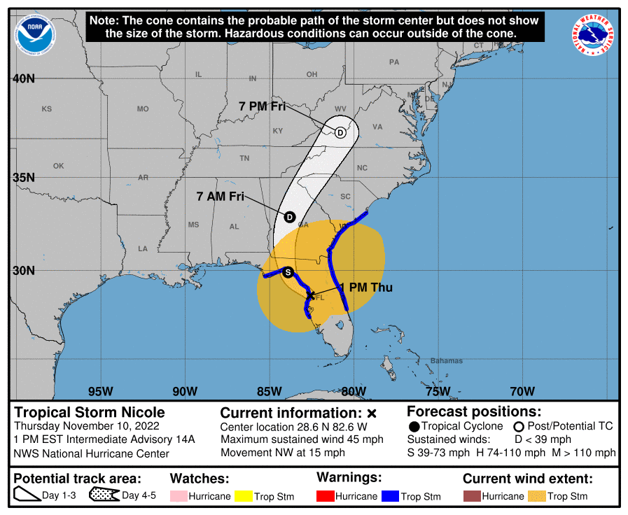
According to the National Hurricane Center, little change in strength is expected while Nicole is over the Gulf of Mexico this afternoon and evening. Nicole is expected to weaken to a depression over Georgia tonight, and then it is expected to merge with a frontal boundary over the Mid-Atlantic United States by Friday night. At this time, it doesn’t appear the merging with the frontal boundary will make the storm worse. However, threats of flooding rain, storm surge, gusty winds, and isolated tornadoes will continue.
Nicole remains a large tropical storm. Tropical-storm-force winds extend outward up to 345 miles from the center, especially to the northeast. During the past few hours, there have been numerous reports of wind gusts of 45 to 55 mph across the eastern and northern portions of the Florida Peninsula.
Tropical storm conditions will continue along the east coast of Florida, Georgia, and South Carolina within the warning areas today. Tropical storm conditions will spread northward along the west coast of Florida to the coast of the Florida Panhandle through tonight.
A dangerous storm surge is expected along portions of the east-central and northeastern coast of Florida, portions of coastal Georgia, and the Florida Big Bend along the Gulf coast. The storm surge will be accompanied by large and damaging waves along the Atlantic coast. Residents in the warning area should listen to advice given by local officials.
The National Hurricane Center cautions: “Do not focus on the exact track of Nicole since it is a large storm with hazards extending well to the north of the center, outside of the forecast cone. These hazards will continue to affect much of the Florida peninsula and portions of the southeast United States.”
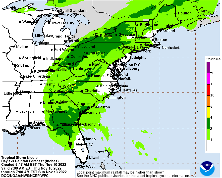

Nicole will produce heavy rainfall today across the Florida Peninsula. Flash and urban flooding will be possible across portions of the Florida Peninsula along with renewed river flooding on the St. Johns River. Isolated flash, urban, and small stream flooding will also be possible on Friday in the Southeast through the central Appalachians, including the Blue Ridge Mountains, and extending northward through eastern Ohio, west central Pennsylvania, into western New York by Friday night into Saturday.
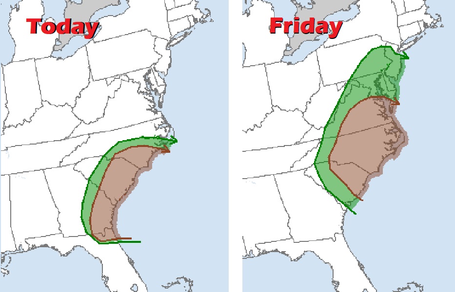
In addition to threats of rain, wind, and coastal storm surge flooding, there is also a tornado threat along portions of the coastal plain. Today, the threat zone extends from northeastern Florida into central North Carolina, with the greatest threat areas over southeastern North Carolina, eastern South Carolina, eastern Georgia, and far northeastern Florida. Tomorrow, this threat zone will shift north up the coast, bringing an increased threat of tornadoes to the Mid Atlantic. On Friday, the southern two-thirds of New Jersey, all of Delaware, southeastern Pennsylvania, much of Maryland, Virginia,and North and South Carolina are in an area of increased tornadic activity. Within this area, most of southeastern Virginia, central and eastern North Carolina, and northeastern South Carolina are at greatest risk of seeing tornadic cells from Hurricane Nicole’s remnants.
The tornadic possibilities over the next 48 hours are reminiscent of the tornado outbreak created by the remnants of Ida last year. That storm was responsible for 7 tornadoes in New Jersey alone which destroyed communities in southern New Jersey, far away from where Ida first came ashore in Louisiana.
