The National Hurricane Center in Miami, Florida has issued Hurricane Watches, Tropical Storm Watches, and a Storm Surge Watch ahead of what will likely be the landfall of Hurricane Henri this weekend.
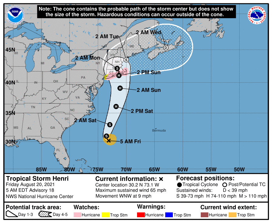
Henri is expected to intensify into a formidable hurricane and grow in size with time before making a landfall later this weekend along the northeast coast. While the area from New Jersey to Maine will see direct impacts from this storm, it appears Long Island, Connecticut, Rhode Island, and Massachusetts will see the worst conditions with a landfalling hurricane eye expected near there.
A Hurricane Watch is now in effect for the South Shore of Ling Island from Fire Island Inlet to Montauk, the North Shore of Long Island from Port Jefferson Harbor to Montauk, for the area from New Haven, Connecticut to Sagamore Beach, Massachusetts, and for Nantucket, Martha’s Vineyard, and Block Island. A Hurricane Watch means that hurricane conditions are possible within the watch area. A watch is typically issued 48 hours before the anticipated first occurrence of tropical-storm-force winds, conditions that make outside preparations difficult or dangerous.
A Storm Surge Watch is in also in effect for the South Shore of Long Island from East Rockaway Inlet to Montauk, the North Shore of Long Island from Kings Point to Montauk, for the area from Kings Point, New York to Sagamore Beach, Massachusetts, and for Nantucket, Martha’s Vineyard, and Block Island. A Storm Surge Watch means there is a possibility of life-threatening inundation, from rising water moving inland from the coastline, in the indicated locations during the next 48 hours.
Lastly, a Tropical Storm Watch has been issued for west of Fire Island Inlet to East Rockaway Inlet, New York, west of Port Jefferson Harbor, New York, and west of New Haven, Connecticut. A Tropical Storm Watch means that tropical storm conditions are possible within the watch area, generally within 48 hours.
Henri is forecast to be near the northeast coast of the U.S. on Sunday and Monday, and the risks of storm surge, wind, and rain impacts in portions of southern New England and eastern Long Island are increasing. The National Hurricane Center says additional watches or warnings may be required later today.
Swells from Henri will begin to reach much of the east coast of the U.S. and Atlantic Canada by the end of the week and continue through the weekend. These swells could cause life-threatening surf and rip currents.
Heavy rainfall may lead to flash, urban, and small stream flooding over portions of southern New England Sunday into Monday.
