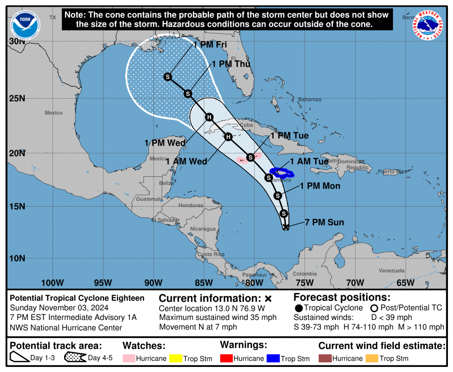
A developing system in the Caribbean has prompted the National Hurricane Center (NHC) to classify it as Potential Tropical Cyclone #18. The NHC forecasts this system to become a tropical storm by Monday morning, being named Rafael in the process. The NHC forecast brings the system close to the west coast of Jamaica as it intensifies. By the time the storm is expected to cross western Cuba before entering the Gulf of Mexico, it is forecast by the NHC to become a hurricane. Because of that, the Cayman Islands are now under a Hurricane Watch.
A Hurricane Watch means that hurricane conditions are possible within the watch area. A watch is typically issued 48 hours before the anticipated first occurrence of tropical-storm-force winds, conditions that make outside preparations difficult or danger.
Right now, the center of the disturbance was estimated to be near latitude 13.0 North, longitude 76.9 West which is 345 miles south of Kingston, Jamaica. The system is currently drifting slowly, but is expected by the NHC to soon begin moving toward the north near 7 mph. A turn to the northwest is expected to occur tomorrow and continue for the next few days. On the forecast track, the system is expected to move near Jamaica by late Monday and near or over the Cayman Islands Tuesday and Wednesday.
This system is expected to become a tropical depression tonight or tomorrow and steady strengthening is forecast beyond that time.
Hurricane conditions are possible in the Cayman Islands on Tuesday. Tropical storm conditions are expected in Jamaica by late Monday.
Heavy rainfall will impact areas of the western Caribbean with the heaviest rainfall occurring over Jamaica and southern Cuba through mid-week. Rainfall totals between 3 to 6 inches with locally up to 9 inches are expected. Flooding could occur over portions of Jamaica and Cuba, with mudslides possible.
Heavy rainfall will spread north into Florida and adjacent areas of the Southeast United States mid to late week.
Minor coastal flooding is possible in Jamaica on Monday and the Cayman Islands on Tuesday.
Swells generated by the system are expected to affect much of the western Caribbean during the next few days.
Where the storm goes beyond Cuba remains questionable. While the NHC forecast brings the storm to the middle of the Gulf of Mexico by next Friday, the American GFS forecast model suggests it to turn towards the Florida coast while the European ECMWF model brings it to the north coast of Houston. As the storm takes shape and heads north, there will be more confidence in the storm’s future track.
