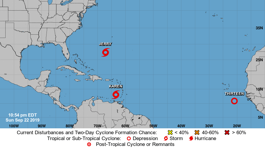
The tropical Atlantic is busy with the National Hurricane Center (NHC) tracking three systems: Tropical Storms Jerry and Karen and newly formed Tropical Depression #13. Over time, this tropical depression is expected to grow into a named tropical cyclone; when it becomes named, it’ll be called Lorenzo.
Moments ago, the Bermuda Weather Service issued a Tropical Storm Watch for Bermuda. A Tropical Storm Watch means that tropical storm conditions are possible within the watch area, generally within 48 hours. The center of Tropical Storm Jerry was located near latitude 27.4 North, longitude 67.2 West. Jerry is moving toward the north-northwest near 10 mph and the NHC expects this general motion to continue on Monday. A turn to the north is expected Monday night followed by a turn to the northeast on Tuesday. Based on the official track from the NHC, the center of Jerry is expected to pass near Bermuda by Tuesday night. Maximum sustained winds are near 65 mph with higher gusts. Gradual weakening is expected during the next few days. Tropical-storm-force winds extend outward up to 115 miles from the center. The estimated minimum central pressure is 993 mb or 29.33 inches of mercury. In addition to dumping 1-3″ of rain on Bermuda, rough surf will pound the northern Leeward Islands and Puerto Rico for another day or so. These swells are likely to cause life-threatening surf and rip current conditions.
Karen, which formed last night, is prompting the issuance of advisories. While the Government of Trinidad and Tobago has discontinued the Tropical Storm Warning for Grenada and its dependencies this evening, a Tropical Storm Watch is in effect for the U.S. Virgin Islands, Puerto Rico, including Vieques and Culebra, and the British Virgin Islands. Moments ago, the center of Tropical Storm Karen was located near latitude 13.1 North, longitude 63.5 West. Karen is moving toward the west-northwest near 12 mph. A turn toward the northwest is forecast to occur on Monday, followed by a turn toward the north on Tuesday. On the forecast track, the center of Karen will move across the eastern Caribbean Sea tonight through Monday night. On Tuesday, Karen is expected to pass near or over Puerto Rico and the Virgin Islands. Maximum sustained winds are near 40 mph with higher gusts. Little change in strength is expected during the next couple of days. Tropical-storm-force winds extend outward up to 105 miles to the northeast of the center. The estimated minimum central pressure is 1007 mb or 29.74 inches of mercury. 2-4″ of rain with isolated amounts up to 8″ is possible in Karen’s path; these rains may cause flash flooding and mudslides, especially in mountainous areas. It is still too soon to say with certainty what, if any, impacts, direct or indirect, Karen may have on the Bahamas or the United States.
While Jerry and Karen are spinning about, a new tropical depression has just formed in the far eastern Atlantic.As of 11pm, the center of Tropical Depression Thirteen was located near latitude 10.8 North, longitude 20.9 West. The depression is moving toward the west near 16 mph. A general motion toward the west is expected through Monday, with a motion toward the west-northwest expected Monday night and Tuesday. On the forecast track, the center of the depression should pass well south of the Cabo Verde Islands. Maximum sustained winds are near 35 mph with higher gusts. According to the National Hurricane Center, steady strengthening is expected, with the depression forecast to become a tropical storm on Monday and a hurricane by Tuesday night. Once the system reaches tropical storm strength, it will be named Lorenzo. The estimated minimum central pressure for now is 1007 mb or 29.74 inches.