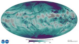
The new polar orbiting weather satellite that was launched into space just weeks ago has sent back its first data. The National Oceanic and Atmospheric Administration (NOAA) released a global view map that shows the temperature profile of the atmosphere through one of the many channels the orbiting hi-tech device is measuring. This particular channel is used in the making of the NOAA/NESDIS Blended Total Precipitable Water (TPW) product that meteorologists and emergency managers use for precipitation guidance and flood alerts.
This image uses ATMS data to depict the location and abundance of water vapor (as associated with antenna temperatures) in the lower atmosphere, from the surface of the Earth to 5 kilometers altitude. Transparent/grey colors depict areas with less water vapor, while blue-green and purple colors represent abundant water in all phases (vapor, clouds, and precipitation) in low and middle latitudes. In the polar regions, purple depicts surface snow and ice.
While known as JPPS-1 through launch, the satellite has been renamed “NOAA20”, a welcome addition to the fleet of weather satellites monitoring the Earth’s weather for NOAA and its member agencies such as the National Weather Service and National Hurricane Center. JPSS-1 continues the NOAA operational polar satellite sounder missions which dates back to the 1970’s. NOAA-20 with be the 20th operational polar satellite for NOAA.