Saltwater kept flooding low-lying streets in the Florida Keys and along Florida’s Atlantic coast on Saturday as a week of exceptionally high king tides slowly eased, and forecasters warned that heavy rain arriving Sunday could add to the flooding before the water fully drains away.
The National Weather Service in Key West kept a coastal flood warning for “major saltwater flooding” in effect for the Upper and Middle Keys until 4 a.m. Sunday. Forecasters said numerous roads may be closed and that low-lying homes, businesses and some critical infrastructure would be inundated.
Peak high tides near 1 a.m. Saturday were lower than on previous nights, allowing forecasters to downgrade the Lower Keys from a warning to a coastal flood advisory, the Key West office said in its morning forecast discussion. But high tides in the Middle and Upper Keys “were still on the higher end of the Moderate Flood category,” and forecasters said receding rates “will be slow, especially in the Upper Keys.”
The office also said there is “increasing confidence in a wet, stormy period from tonight through Monday.”

Highest Water Outside a Hurricane
The flooding has been building since the October king tides, the highest predicted tides of the year, coincided with persistent northeast winds. The South Florida Water Management District listed Oct. 27 as the annual maximum predicted tide peak for the southeast Florida coast and Oct. 28 and Oct. 30 for the Keys.
On Tuesday, water levels in Fort Lauderdale and Miami reached about 2.5 feet above normal high tide, reaching major flood levels, theweather.com reported, citing the weather service. At the Virginia Key tide gauge in Miami, water reached its highest level outside of a hurricane since records began in 1994, with only Hurricane Irma in 2017 producing a higher reading, the outlet reported.
The tide gauge in Key West recorded a preliminary peak that ranked fifth-highest of all time, the weather service’s Key West office told Keys Weekly this week.
Jon Rizzo, warning coordination meteorologist for the weather service in Key West, told the newspaper that the full moon, the highest tides of the year and a buildup of water caused by Subtropical Storm Josephine the week before were producing some of the highest water levels observed outside of an actual storm.
“Streets, parking lots, docks and yards that are frequently overtopped by typical king tide flooding could see water levels nearly a full foot higher than in ‘typical’ king tide events,” Rizzo said.
In the Stillwright Point subdivision in Key Largo, saltwater swamped streets early in the week. Resident Emilie Stewart told Keys Weekly on Monday that the flooding blocked cars from her street.
“You cannot get a car down North Blackwater today,” Stewart said. “It is as deep now as it had been past years after a hurricane.”
Stewart said the flooding affected garbage pickup and mail delivery in the neighborhood. Key Largo Fire Rescue advised residents in low-lying areas to move their cars to higher ground and warned against driving or walking through flooded roads, which can hide potholes, debris and washouts, the newspaper reported.
Stillwright Point residents have dealt with king tide flooding for years. In fall 2019, saltwater covered streets in the community for 94 consecutive days, Keys Weekly reported. The Monroe County Commission later decided not to pursue a $40 million project that would have raised the roads about 2.65 feet and added a pump station, after the county could not secure full support from residents for the required easements, the newspaper said.
Southeast Coast Stuck Near Moderate Flood Stage
On the mainland, a coastal flood advisory for moderate coastal flooding remained in effect for coastal Miami-Dade, Broward and Palm Beach counties through Sunday, the weather service in Miami said. Forecasters warned of flooding of lots, parks and roads, with isolated road closures.
“Though we’re on the back side of the King Tide peak, water levels are struggling to fall below moderate stage during high tide cycles due to the persistent, and at times strong, onshore flow,” the Miami office wrote Saturday.
Forecasters said water levels might briefly drop below moderate flood stage late Sunday through Monday, but that once easterly winds return early next week, tides could again approach moderate flood stage.
In Fort Lauderdale, canal water topped a seawall and pushed up through storm drains near Las Olas Boulevard and Coconut Isle Drive on Friday morning, WSVN-TV reported. The city offered residents free parking on upper floors of the Riverwalk Center Garage through Friday evening to protect vehicles, and listed a high-tide peak of 1:15 p.m. Saturday, according to the Fort Lauderdale Review.
The same winds pushing water ashore are churning the surf. A high surf advisory for Palm Beach and Broward counties called for breaking waves around 5 to 8 feet through at least Monday morning, with a high risk of rip currents.
Farther north, the weather service office in Melbourne issued a coastal flood advisory for minor flooding in St. Lucie and Martin counties until 7 p.m. Sunday and a high surf advisory for breaking waves of 5 to 7 feet.
St. Johns River Still High
The river near Astor, in Lake and Volusia counties, stood at 3.6 feet Friday evening, above its flood stage of 2.3 feet, and was expected to remain steady, the Melbourne office said in a flood warning that remains in effect until further notice. Forecasters said persistent northeast winds and tidal effects downstream were slowing the river’s flow.
At that level, canals overflow into yards, homes on or near Wildhog, Bonnet and Snail roads become inaccessible, with several inches of water inside homes along the river and canals, and docks at the Astor Bridge marina are completely submerged, according to the warning.
The weather service in Jacksonville kept a coastal flood warning for eastern Putnam County until 5 a.m. Sunday, with moderate flooding of around 2 feet above normally dry ground expected along the river there. Elsewhere along the northeast Florida coast and lower St. Johns River, mostly minor flooding of about 1.5 to 2 feet above normally dry ground was forecast at high tide, the office said.
Earlier in the week, a weather service forecaster said the impacts in northeast Florida resembled those of a tropical storm, News4JAX reported. Residents of Coquina Avenue used kayaks to reach their homes, and St. Augustine delayed the opening of City Hall and several government offices because of flooding, the station reported.
Heavy Rain on the Way
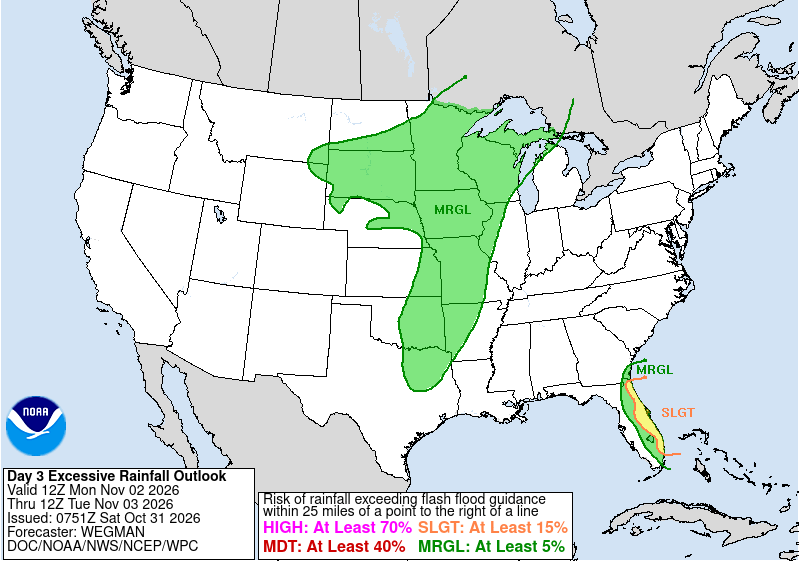
The Weather Prediction Center placed much of Florida’s east coast, extended north through the Jacksonville metro area, under a Slight Risk of excessive rainfall, level 2 of 4, for Sunday and kept the risk along the entire Interstate 95 corridor for Monday. The center said a wave of tropical moisture crossing the peninsula would bring widespread rain and that “the east coast of the state continues to have saturated soils from numerous consecutive days of rainfall.”
The Jacksonville office said 2 to 3 inches of rain, with locally higher amounts, is a reasonable expectation Sunday afternoon into Monday. In South Florida, the Miami office said a reasonable worst case is 1.5 to 2 inches on average, but 3 to 5 inches where bands of heavy rain set up.
The National Hurricane Center said Saturday that no tropical cyclone formation is expected in the Atlantic basin over the next seven days.
