
King tides and a persistent onshore wind pushed saltwater into streets and homes along Florida’s Atlantic coast for a third straight day Wednesday, after a tide gauge in Miami recorded one of the highest water levels in its history.
National Weather Service offices in Key West, Miami, Melbourne and Jacksonville kept coastal flood warnings in effect Wednesday from the Florida Keys to southeast Georgia. The Key West office said the Keys faced “major saltwater flooding” until 5 a.m. EDT Thursday.
The Virginia Key tide gauge in Miami recorded its third-highest peak on Tuesday since consistent records began there in 1994, trailing only hurricanes Wilma and Irma, according to the weather service.
Yesterday’s water level was near-record. The National Weather Service said Tuesday’s peak at the Virginia Key gauge was the third-highest since consistent records began in 1994. Only hurricanes Wilma and Irma produced higher water there. Preliminary NOAA data show the water peaked about 2.5 feet above the normal high-tide line, roughly 1.8 feet above the predicted tide.
Warnings related to the flooding cover about 500 miles of coastline. Coastal flood warnings stretch from the Florida Keys, which face “major saltwater flooding” until 5 a.m. EDT Thursday, north through Palm Beach County, the Space Coast, northeast Florida, the St. Johns River basin and coastal Glynn and Camden counties in Georgia.
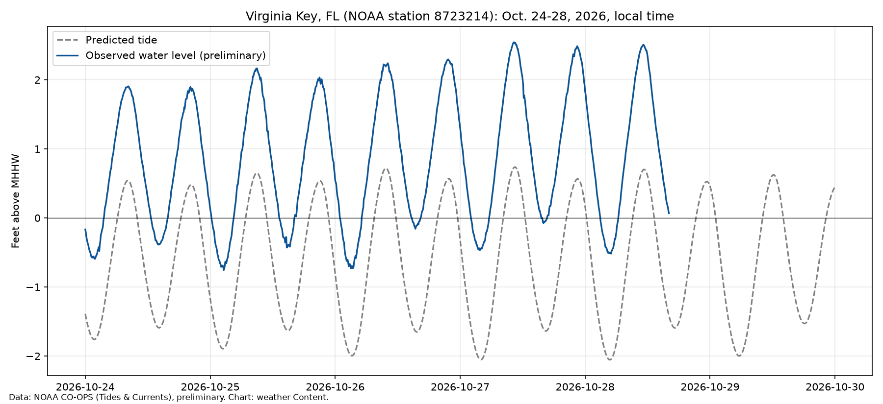
It appears the water will go down slowly. The Atlantic tropics are quiet and winds are expected to ease, but forecasters said moderate flooding at high tide will continue into Thursday and, in some places, through the weekend.
“King Tide” is not a scientific term. NOAA uses it to describe exceptionally high tides, which usually occur around new or full moons and when the moon is at perigee, its closest point to Earth. The weather service office in Jacksonville said high astronomical tides tied to Wednesday’s lunar perigee are adding to the problem.
The weather service office in Miami said South Florida sits on the edge of a midlevel low near the Bahamas, with a surface low nearby. Persistent northeasterly winds between that low and high pressure over the eastern U.S. have pushed ocean water toward the coast for days.
Preliminary six-minute data from NOAA’s Center for Operational Oceanographic Products and Services show the Virginia Key gauge, station 8723214, peaked at about 2.54 feet above mean higher high water at 10:18 a.m. EDT Tuesday, Oct. 27. Mean higher high water is roughly the average height of the daily high tide. At that moment, the predicted astronomical tide was about 0.73 feet above that mark, meaning wind and weather added roughly 1.8 feet of water.
The USA TODAY Network, citing the weather service, reported that the reading was the gauge’s “3rd highest peak value” since consistent records began in 1994, behind only Hurricane Wilma in 2005 and Hurricane Irma in 2017. Other NOAA gauges also ran high Tuesday morning. Preliminary readings reached about 2.7 feet above mean higher high water at Lake Worth Pier in Palm Beach County and about 2.4 feet at Mayport near Jacksonville.
The Miami Herald reported that on Tuesday “an unprecedented amount of saltwater surged ashore from Miami to West Palm Beach,” covering lanes on major roads and flooding coastal businesses and homes. CBS News Miami described “days of relentless high tide flooding,” with numerous road closures and flooded properties in low-lying areas.
The South Florida Water Management District’s October 26 king tide forecast, as reported by USA TODAY, warned that tidal water levels along South Florida’s east coast could stay above the weather service’s “Moderate Flooding” threshold, with some locations approaching the “Major Flooding” threshold.
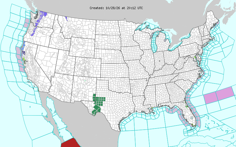
Numerous areas remain under warnings for coastal flooding:
Florida Keys
The Key West office’s coastal flood warning calls for major saltwater flooding in the Upper, Middle and Lower Keys until 5 a.m. EDT Thursday. Forecasters said there would be “little relief during the periods of low tide, especially in the Upper Keys.”
Southeast Florida
Coastal Palm Beach, Broward and Miami-Dade counties are under a coastal flood warning for “significant coastal flooding” until 8 p.m. EDT Wednesday, the Miami office said. A coastal flood advisory for moderate flooding follows until 8 p.m. EDT Thursday. Palm Beach County also has a high surf advisory for breaking waves of 6 to 14 feet through Wednesday evening and a high rip current risk through Thursday evening.
East-central Florida
The Melbourne office’s coastal flood warning covers coastal Volusia, Brevard, Indian River, St. Lucie and Martin counties, with breakers of 7 to 11 feet and a high rip current risk through late Friday night. Forecasters said training bands of heavy showers could cause flooding, “especially locations that are already impacted by coastal flooding.”
Northeast Florida and southeast Georgia:
Coastal flood warnings for moderate flooding at high tide cover the northeast Florida beaches, the Intracoastal Waterway, the entire St. Johns River basin and coastal Glynn and Camden counties in Georgia until 2 a.m. EDT Friday. The Jacksonville office said water levels would reach 2 to 3 feet above mean higher high water at high tide through Thursday, and moderate tidal flooding may last into the weekend in the St. Johns River basin.
The National Hurricane Center said in its 2 p.m. EDT tropical weather outlook that tropical cyclone formation is not expected during the next seven days in the Atlantic, Caribbean or Gulf. The Miami office said it expects the offshore low to drift northeast and the strongest winds to shift north of South Florida. Local media reported that the highest water in South Florida arrives roughly between 10 a.m. and 1 p.m. and again between 10 p.m. and 1 a.m.
Officials are providing advice for people to stay safe:
- Don’t drive, walk or wade through saltwater. The city of Miami said floodwater can hide hazards and pollutants. Anyone who touches it should wash with soap and hot water.
- Move vehicles to higher ground before high tide, and have flooded cars checked.
- Stay out of the ocean. Rip currents and high surf remain dangerous along the coast.
