Tropical Storms Laura and Marco are gaining strength this afternoon and are forecast to become hurricanes as they enter the Gulf of Mexico. From there, both are likely to impact the Gulf Coast or where exactly or how strong it’ll be when it happens remains in question. Even before the storms enter the Gulf, they will create problems for those in their path across portions of Mexico and the Caribbean.
Even the Florida Keys are under the gun, with authorities in Monroe County declaring a State of Local Emergency and mandating evacuations. The Emergency Operations Center there says Laura poses a “threat of danger to the populace inhabiting Monroe County” and that the County “may require expedient action in order to protect the health, safety and welfare of the community.” Mandatory evacuations are in effect there for all liveaboard vessels, mobile homes, recreational vehicles, travel trailers, and campers. Recreational vehicles must be removed from Monroe County by noon tomorrow.
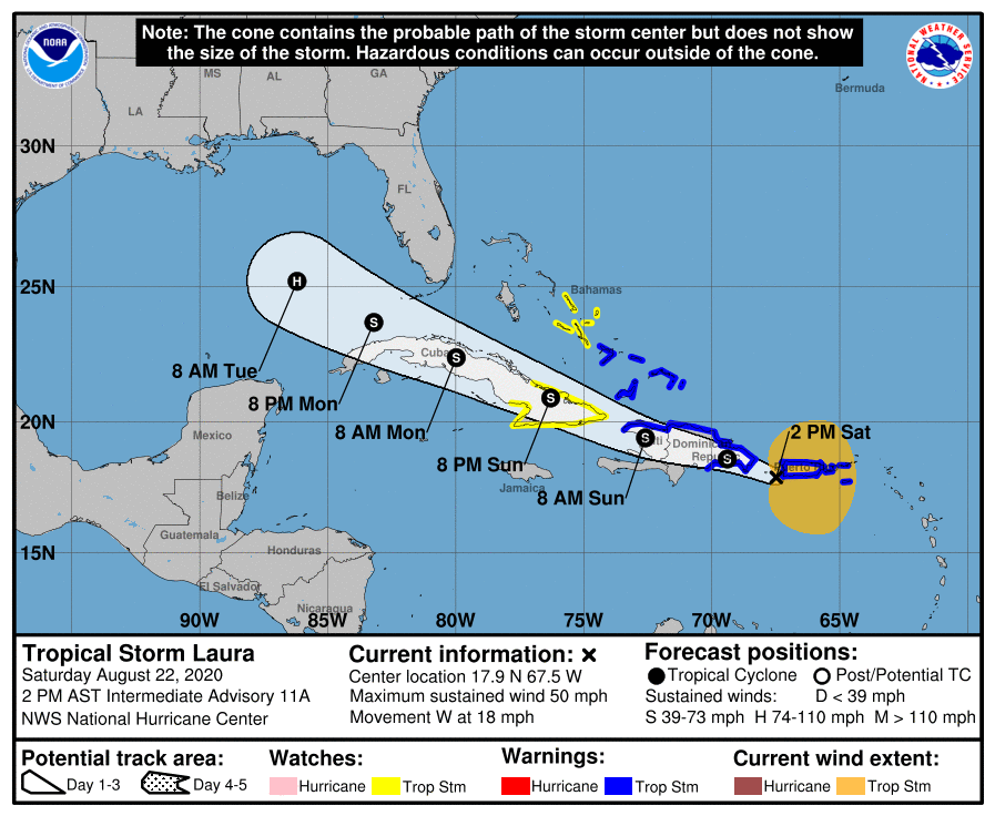
For now, Tropical Storm Laura is about 60 miles southwest of Ponce, Puerto Rico with maximum sustained winds now up to 50 mph. A Tropical Storm Warning is in effect for all of Puerto Rico including Vieques and Culebra, the U.S. Virgin Islands, the northern coast of the Dominican Republic from Cabo Engano to the border with Haiti, the southern coast of the Dominican Republic from Cabo Engano to Punta Palenque, the northern coast of Haiti from Le Mole St. Nicholas to the border with the Dominican Republic, and the southeastern Bahamas and the Turks and Caicos Islands. A Tropical Storm Watch is in effect for the central Bahamas, the Cuban provinces of Las Tunas, Holguin, Guantanamo, Santiago de Cuba, and Granma. A Tropical Storm Warning means that tropical storm conditions are expected somewhere within the warning area soon. A Tropical Storm Watch means that tropical storm conditions are possible within the watch area, generally within 48 hours. The National Hurricane Center (NHC) says Tropical Storm Watches may be needed for the Florida Keys later today.
For now, Laura is moving toward the west near 18 mph and a generally west-northwestward motion is expected over the next few days. On the forecast track, the center of Laura will move away from Puerto Rico this afternoon, near or over Hispaniola this afternoon and tonight, and near or over eastern Cuba Sunday and Sunday night. Some additional strengthening is possible until the center moves over Hispaniola tonight.
Because of it’s path over land and due to it’s increasing proximity to Marco over time, intensity and track forecasts for Laura’s future have lower than usual confidence for now. It is likely Laura will eventually enter the Gulf of Mexico over time and become a hurricane, but specifics beyond that aren’t yet available with confidence.
Laura will bring 3-6″ of rain with localized amounts up to 8″ in Puerto Rico; 4-8″ with localized amounts of 12″ are possible in the Dominican Republic and Haiti; Cuba could see 3-6″ with isolated amounts up to 8″ too. All of this heavy rainfall could lead to life-threatening flash and urban flooding, and the potential for mudslides across the Greater Antilles. Widespread minor to potential moderate river flooding is possible in Puerto Rico.
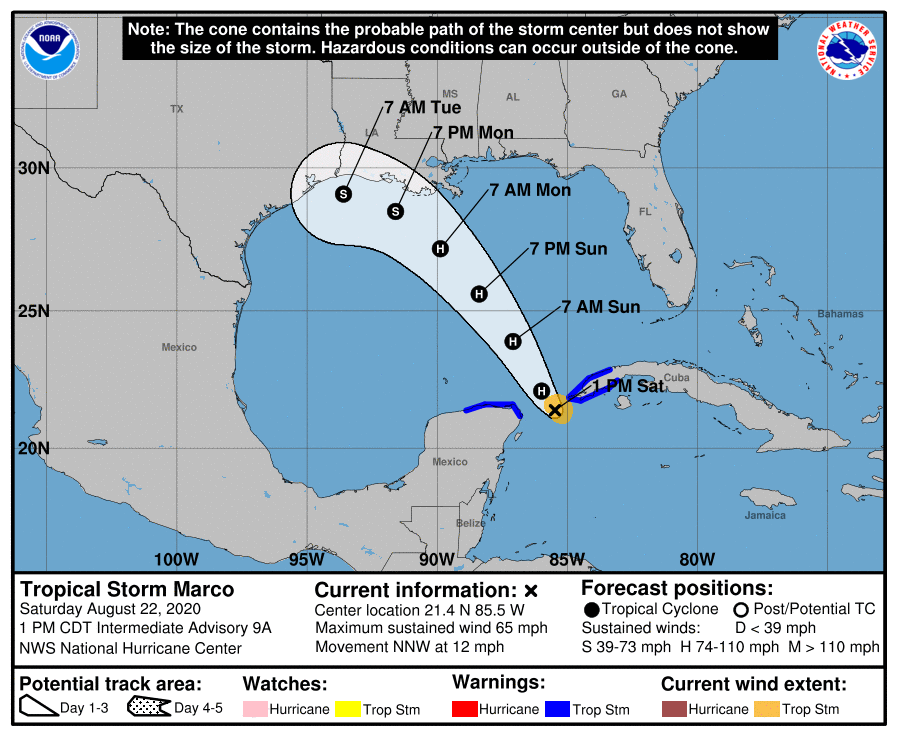
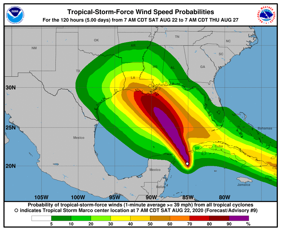
While Laura spins about near Puerto Rico, Marco is gaining strength near Mexico’s Yucatan Peninsula. As of the latest advisory from the National Hurricane Center, Marco was 90 miles east northeast of Cancun, Mexico and 50 miles southwest of the western tip of Cuba. Maximum sustained winds are near 65 mph and Marco is expected to become a hurricane soon.
A Tropical Storm Warning is in effect for the Province of Pinar del Rio on Cuba and from Cancun to Dzilam in Mexico. A Tropical Storm Warning means that tropical storm conditions are expected somewhere within the warning area, in this case within the next 6-12 hours. The National Hurricane Center cautions interests along the coasts of Louisiana and Texas that watches will likely be required for a portion of this area later today.
Marco is moving toward the north-northwest near 12 mph and this general motion is expected to continue through Sunday morning. A gradual turn toward the northwest and west-northwest is expected to begin Sunday afternoon and continue through Tuesday morning. On the forecast track, Marco’s center will move into the southeastern Gulf of Mexico by this evening. Marco will then move across the central Gulf of Mexico on Sunday and approach the central and northwestern Gulf coast on Monday and Tuesday. Strengthening is forecast during the next day or two, and Marco is expected to become a hurricane later today or tonight.
However, depending what happens with Laura’s future track, some weakening could occur on Monday and Tuesday. Even if weakening occurs, Marco could be a very hazardous tropical cyclone when it reaches to the U.S. coastline.
Today, Marco is expected to produce 1-4″ of rain with isolated maximum amounts of 6″ possible across the eastern portions of the Mexican states of Quintana Roo and Yucatan, and across far western Cuba. This rainfall may result in areas of flash flooding.
