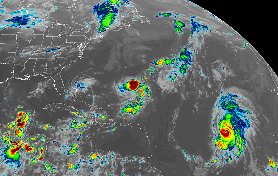
Hurricane Lorenzo has grown into a large, major hurricane in the central Atlantic while Tropical Storm Karen is losing its structure.
As satellite photography shows, Lorenzo is a large hurricane; hurricane-force winds extend outward up to 45 miles from the center and tropical-storm-force winds extend outward up to 255 miles. Lorenzo’s cloud canopy is larger than its wind field, taking up real estate that’s approximately the same area as what’s between Maine and South Carolins.
In the latest advisory from the National Hurricane Center, the center of Hurricane Lorenzo was located near latitude 16.5 North, longitude 40.8 West. Lorenzo is moving toward the northwest near 12 mph and the NHC expects this motion to continue through tonight. A turn toward the north-northwest is expected on Friday, followed by a turn toward the north on Saturday. Maximum sustained winds have increased to near 140 mph with higher gusts. Lorenzo is a category 4 hurricane on the Saffir-Simpson Hurricane Wind Scale. Additional strengthening is possible tonight, and fluctuations in intensity are expected Friday and Saturday. The estimated minimum central pressure is 943 mb or 27.85 inches.
While Lorenzo is a massive, powerful hurricane, Karen, as a tropical storm, is falling apart closer to the United States. Located near latitude 27.2 North, longitude 62.9 West. Karen is moving toward the north-northeast near 12 mph. The storm is expected to turn eastward and become nearly stationary by Friday night, and then begin moving westward over the weekend. But even with a forecast westward drift, the National Hurricane Center believes Karen will degrade into a remnant low by Saturday. For now Karen is a minimal tropical storm with maximum sustained winds of 45 mph. Tropical-storm-force winds extend outward up to 60 miles, making it nearly 1/4 the size of Lorenzo. The estimated minimum central pressure is 1005 mb or 29.68 inches.
