Image: Alaska Department of Transportation and Public Facilities via Wikimedia Commons
A magnitude 3.5 earthquake rumbled beneath the upper Susitna Valley north of Anchorage on Sunday morning, producing weak shaking reported by a handful of people and no indications of damage, according to the U.S. Geological Survey.
The quake struck at 8:13 a.m. AKST Sunday, Nov. 15, which was 11:13 a.m. CST and 17:13 UTC. USGS located the epicenter about 20 kilometers, or 12 miles, east-northeast of Susitna North, a community in the Matanuska-Susitna Borough. A ShakeMap produced by the Alaska Earthquake Center described the location as 36 kilometers, or 23 miles, east-southeast of Talkeetna.
The event is listed with a local magnitude of 3.5 and a “reviewed” status in the USGS earthquake catalog, meaning a seismic analyst has checked the automatic solution. The preferred solution, from the Alaska Earthquake Center at the University of Alaska Fairbanks, places the hypocenter at a depth of 9.4 kilometers, or about 5.8 miles.
The USGS National Earthquake Information Center computed a separate solution for the same event, with a magnitude of 3.3 and a depth of about 47 kilometers, or 29 miles. The catalog lists the Alaska center’s solution as preferred. Differences of that kind are not unusual for small earthquakes, because agencies use different station sets and velocity models, and depth is often the hardest value to pin down. If the shallower depth is correct, the quake occurred within the crust of the North American Plate. If the deeper solution is correct, it would fall in the depth range typical of earthquakes inside the subducting Pacific Plate beneath the region.
Shaking was weak. The USGS “Did You Feel It?” system, which collects reports from the public, had received five responses as of early Monday. The highest community intensity reported was 2.7 on the Modified Mercalli Intensity scale, in the range the USGS describes as weak shaking with no damage, from a location about 43 kilometers, or 27 miles, from the epicenter.

Image: Alaska Earthquake Center/U.S. Geological Survey
A response from the Wasilla ZIP code, about 80 kilometers, or 50 miles, away, registered an intensity of 2.2. A response from the Talkeetna ZIP code, about 24 kilometers, or 15 miles, away, and responses from two Anchorage ZIP codes, about 120 kilometers, or 75 miles, away, registered intensity 1, the level that corresponds to shaking not felt.
The Alaska Earthquake Center’s ShakeMap, which estimates ground motion using seismic instruments and reported intensities, put maximum intensity near the epicenter at about 3.6 on the same scale. That falls between weak and light shaking, levels the ShakeMap legend associates with no damage. The map shows the strongest estimated shaking in a small area of mountainous terrain east of Susitna North, well away from Anchorage and the core of the Mat-Su Valley.
USGS did not issue an alert through PAGER, its system for estimating fatalities and economic losses after significant earthquakes. Its catalog showed no tsunami flag for the event, which occurred far inland.
About 11 hours later, at 7:33 p.m. AKST Sunday, which was 10:33 p.m. CST, a magnitude 2.5 earthquake was recorded about 11 kilometers, or 7 miles, north-northeast of Susitna North at a depth of about 5 kilometers, according to the USGS catalog. The agency did not describe the smaller quake as an aftershock.
The USGS catalog lists 29 earthquakes of magnitude 1 or greater within 30 kilometers, or about 19 miles, of Sunday’s epicenter since Oct. 16, a reminder that small earthquakes are routine in the area.
Sunday’s quake was the largest U.S. earthquake with felt reports in the 20 hours ending at 6:34 a.m. CST Monday. A magnitude 3.6 earthquake was recorded at 9:06 p.m. CST Sunday about 271 kilometers, or 168 miles, southeast of Chiniak, far off the coast of Kodiak Island, but the USGS listed no felt reports for that event. In the lower 48 states, the largest felt quake in the same window was a magnitude 2.9 near Silver Springs, Nevada, with four reports.
Southcentral Alaska sits above one of the world’s most active plate boundaries, where the Pacific Plate descends beneath the North American Plate. Catalog depths show that many earthquakes beneath the Anchorage and Mat-Su region occur within that sinking slab, roughly 25 to 45 miles down, while others occur at shallower depths in the overriding crust. The same plate boundary produced the magnitude 9.2 Great Alaska Earthquake of March 27, 1964, the largest earthquake recorded in U.S. history, according to the USGS.
Background from the USGS catalog shows how often moderate earthquakes have struck near Sunday’s epicenter. A search of the catalog lists dozens of earthquakes of magnitude 4.3 or larger within about 31 miles since the 1970s, most of them between about 20 and 45 miles deep. The largest in that search were a magnitude 5.9 quake about 14 miles northeast of Willow on Jan. 1, 1975, and a magnitude 5.8 quake about 9 miles north-northeast of Fishhook on Aug. 14, 1984. The most recent quake in that search was a magnitude 4.4 about 21 miles east-southeast of Susitna North on July 12, 2025.
Image: Dave Bezaire and Susi Havens-Bezaire via Wikimedia Commons
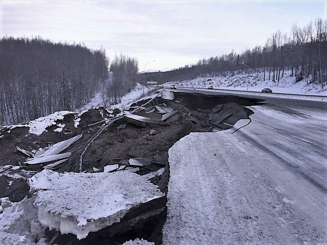
The region’s biggest modern reminder of its seismic risk came Nov. 30, 2018, when a magnitude 7.1 earthquake struck at 8:29 a.m. AKST near Point MacKenzie, just across Knik Arm from Anchorage, about 60 miles south of Sunday’s epicenter. That quake, about 29 miles deep, generated more than 2,300 “Did You Feel It?” reports in the USGS system and damaged roads, homes and other buildings across the Anchorage area and the Mat-Su Valley, including a section of the Glenn Highway near Mirror Lake.
The USGS did not publish an aftershock forecast or special statement for Sunday’s earthquake.
The difference in size between the two events is enormous. Because the magnitude scale is logarithmic, each whole-number step represents about 32 times more energy released. By that measure, the 2018 earthquake released roughly 250,000 times as much energy as Sunday’s magnitude 3.5 quake.
Earthquakes of magnitude 3.5 are generally felt only near the epicenter and rarely cause damage. The Modified Mercalli Intensity scale, which runs from I to X-plus, measures what people experience and what damage occurs at a particular place, while magnitude describes the size of the earthquake at its source. A single earthquake has one magnitude, but intensity varies with distance, depth and local ground conditions.
That helps explain why some people in the Mat-Su area reported feeling the quake while respondents in Anchorage reported they did not. Residents who felt Sunday’s earthquake can still submit reports through the event page on the USGS website, which helps scientists refine shaking maps. Federal and state emergency officials advise people who feel shaking to drop to the ground, take cover under sturdy furniture and hold on until it stops.
USGS reports the earthquake through its event page under the identifier aka2026wqrlbd. The Alaska Earthquake Center, which operates the statewide seismic network, also publishes information on Alaska earthquakes.
Elsewhere in Alaska, no USGS volcano alert-level changes were posted during the same 20-hour period, according to the agency’s volcano notification system. Great Sitkin in the Aleutians remained at orange, or watch, with a slow eruption of lava in its summit crater continuing, according to the Alaska Volcano Observatory’s most recent weekly
