Image: NOAA/National Weather Service Melbourne
Two weeks after a historic deluge swamped Florida’s Space Coast, forecasters said Monday that a new stretch of heavy rain could bring more flooding to the same region this week, while the St. Johns River remains near record levels west of Cocoa.
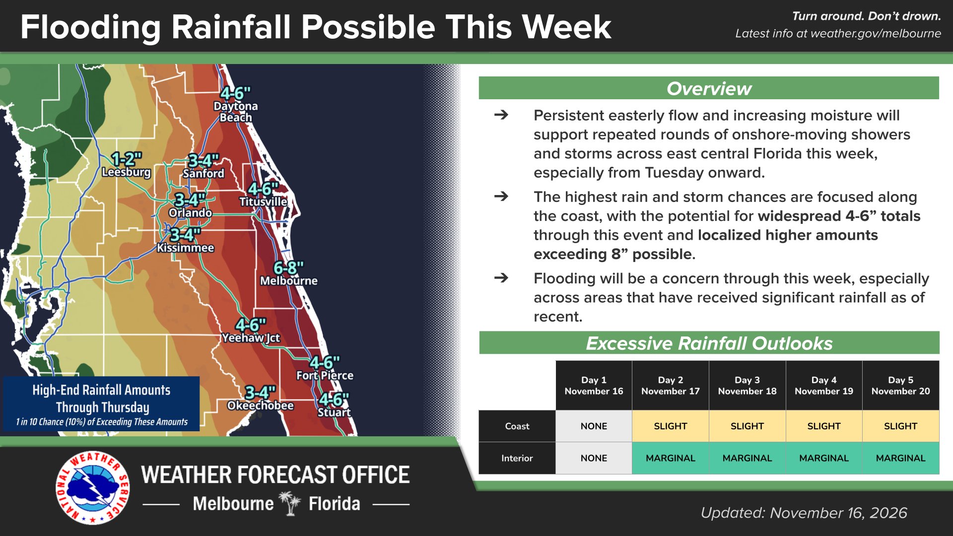
The National Weather Service office in Melbourne said in its forecast discussion early Monday that the risk of excessive rainfall and flooding of roads and low-lying areas “has increased Tuesday through Friday.” The agency said the greatest potential for flooding is along the coast south of Cape Canaveral, especially Wednesday and Thursday.
The Weather Prediction Center has placed a stretch of Florida’s Atlantic coast under a slight risk, Level 2 of 4, for excessive rainfall on Tuesday, with a marginal risk, Level 1 of 4, farther inland. The Melbourne office said it expects the coastal slight risk to continue each day through Friday.
The rain comes as communities along the St. Johns River are still coping with slow-moving floodwater from the Nov. 1-2 storm.
At 6:15 a.m. EST Monday, the river near Cocoa measured 17.05 feet, according to the National Water Prediction Service. Flood stage there is 16 feet and major flooding begins at 17 feet. The record shown on the gauge page is 17.5 feet. The forecast issued Sunday evening called for the river to hold near 17 feet through at least Friday.
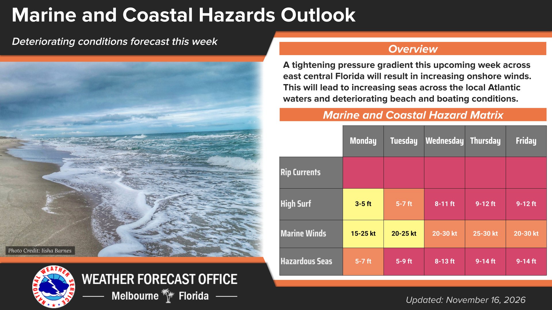
Image: NOAA/National Weather Service Melbourne
In a flood statement issued Sunday night, the weather service said that at 17.2 feet, water enters homes along the river in the Lake Poinsett area west of Cocoa as well as low-lying homes in the Silver Pines subdivision in Rockledge and the Shakespeare Park area of Cocoa. At that level, the agency said, the Providence Road area west of Cocoa becomes impassable, cutting off access to homes in the Mullet Lane and Bass Road area.
Downstream, the river near Geneva above Lake Harney in Seminole County was at 9 feet Sunday evening, a foot above flood stage and in moderate flood. The weather service said water at that level enters the first story of homes on Whitcomb Drive between Crossover Lane and Lake Harney Road and covers Mullet Lake Park. Farther north, the river near Astor, which straddles Volusia and Lake counties, was in minor flood at 2.6 feet.
The weather service said in a statement that “recent extreme rainfall over the headwaters of the St. Johns River” pushed the river near Cocoa into major flood.
“The St. Johns River is one of those unusual rivers that flow north, so it takes a very long time for the water to come through the different tributaries,” Steven Lerner, division manager for Seminole County Emergency Management, told WKMG-TV on Nov. 9. He described the situation as “a very prolonged slow flooding event for us,” and said it could be well into December before water levels begin to fall.
On Saturday, FLORIDA TODAY reported that the river near Cocoa had climbed to 17.09 feet and that water covered Matthew Drive in Rockledge. “I know it’s Florida. I know we live in a swamp. But we know this is a problem,” Rockledge resident Ashley Jimenez told the newspaper.
Brevard County Emergency Management said in a social media post Sunday morning that county debris crews were picking up flood-related debris and urged residents whose homes were damaged to take advantage of dry weather to move ruined items to the curb.
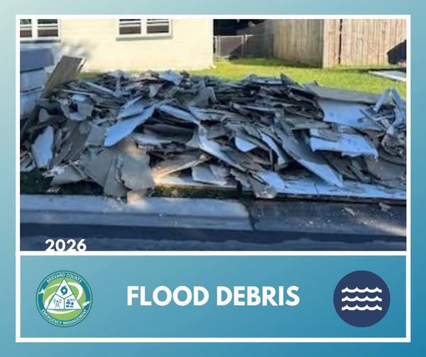
Image: Brevard County Emergency Management
That Dry Spell is Ending
The Melbourne office said strong high pressure over the Ohio Valley, moving toward the mid-Atlantic states, combined with lower pressure south of Florida will create a tight pressure gradient over the region. Northeast to east-northeast winds were forecast to increase to about 15 mph Monday, with gusts of 20 to 25 mph.
On Tuesday, the agency said, sustained winds of 15 to 25 mph with frequent gusts of 20 to 30 mph are expected, with occasional gusts to 35 mph along the coast. Rain chances climb to 40% to 80% across the region Tuesday and Tuesday night, and forecasters said the strongest showers could produce lightning, gusts of 30 to 40 mph and torrential downpours, with isolated totals of 2 to 4 inches or more, highest along the coast.
“It is difficult at this time to pinpoint exactly where the heaviest precip could fall along the coast,” the forecast discussion said. “Do not drive through flooded roadways if you encounter flooding!”
From Wednesday through Friday, forecasters said, a trough aloft will keep drawing deep moisture over the state, and low pressure developing near the Bahamas late in the week will allow heavy rain bands to form over coastal waters and move onshore. The office said widespread totals of 2 to 4 inches “seems appropriate for now,” with isolated amounts of 5 to 7 inches or more possible through Friday. It cautioned that confidence remains low on exactly where the heavy bands will set up.
A Melbourne office graphic updated Monday showed high-end rainfall amounts, defined as a 1-in-10 chance of being exceeded, of 6 to 8 inches around Melbourne and 4 to 6 inches from Daytona Beach and Titusville south to Fort Pierce and Stuart through Thursday. The graphic listed 3 to 4 inches for Orlando, Sanford and Kissimmee.
The threat extends into South Florida. The weather service office in Miami said Monday there is an increased threat of urban flooding along the east coast of South Florida this week and that “if repeated rounds of heavy rainfall occur, impactful flash flooding is possible.” The office said the Weather Prediction Center raised the excessive rainfall risk to Level 2 of 4 for the Miami, Broward County and Palm Beach County metro areas on Tuesday, Wednesday and Thursday, and that saturated soils from recent heavy rain could make flooding easier to trigger. Forecasters there put confidence in the exact timing of the heaviest rain at just 10% to 30%.
The same wind pattern will churn the Atlantic. The Melbourne office said seas of 3 to 5 feet Monday will build through the week, with rough, pounding surf, minor beach erosion and “numerous, strong life-threatening rip currents.” The office said a high surf advisory may be needed by midweek and that a gale watch for coastal waters may eventually be required for Wednesday and Thursday. Its marine outlook graphic showed breaking waves of 8 to 11 feet Wednesday and 9 to 12 feet Thursday and Friday.
The coming rain follows a storm the weather service described as a 1-in-1,000-year event, according to USA TODAY. Preliminary weather service reports cited by FOX 35 Orlando showed 24.69 inches of rain at Grant-Valkaria, 24.52 inches at Malabar and 22 inches in Palm Bay from the slow-moving system Nov. 1-2.
Palm Bay Mayor Rob Medina confirmed at least two deaths in the area after the flooding, AccuWeather reported. Florida Fish and Wildlife Conservation Commission officers rescued more than 60 people in Melbourne and Palm Bay using helicopters, airboats and other vessels, according to news reports. Gov. Ron DeSantis declared a state of emergency for Brevard and six other counties on Nov. 2 and expanded it Nov. 4 to include Lake, Seminole and Volusia counties along the St. Johns, WKMG-TV reported.
The Melbourne office directs residents to water.noaa.gov/wfo/MLB for the latest river forecasts, which will change as rain falls on the basin this week.
