
A magnitude 5 earthquake that struck off Cape Mendocino last week remains the strongest quake in the United States in the past seven days, and smaller tremors continued to ripple along the offshore plate boundary from Northern California to Oregon through Sunday night, according to the U.S. Geological Survey.
The quake, measured at magnitude 4.96, struck at 8:56 p.m. PST Wednesday, Nov. 4, about 69 miles (111 kilometers) west of Petrolia in Humboldt County, the USGS said. The agency listed the depth at 10 kilometers, about 6 miles, a depth it notes was assigned by an analyst rather than calculated.
The USGS estimated low losses, with a green alert under its PAGER system, the lowest level. The National Tsunami Warning Center in Palmer, Alaska, issued a single information statement at 9:01 p.m. PST.
“There is NO tsunami danger from this earthquake,” the center said.
Felt Along the North Coast
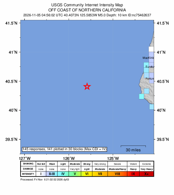
People reported light shaking along the coast. The USGS “Did You Feel It?” system collected 145 responses, with a maximum community intensity of IV, or light shaking. The most reports came from Eureka and Arcata, which together accounted for 80 responses, and single reports came from as far as San Francisco and Portland, Oregon. The highest ZIP code average was in Petrolia, where three people reported weak to light shaking.
The USGS ShakeMap estimated only weak to light shaking on land. MendoLocal.News reported that the nearest communities, Petrolia and Ferndale, lie roughly 70 miles east of the epicenter.
The West Coast’s ShakeAlert earthquake early warning system detected the quake. A USGS summary said a ShakeAlert message was issued about 21 seconds after the quake began, with an initial magnitude estimate of 3.8 that rose to 4.6. The summary said the magnitude was below the threshold for Wireless Emergency Alerts and that the alert may not have been sent to the shaken area.

A Crowded Corner of the Plate Boundary
The epicenter lies west of the Mendocino triple junction, where three tectonic plates meet. In a summary written for a larger quake nearby in 2024, the USGS described the region as the place where the northern end of the San Andreas plate boundary meets the southern end of the Cascadia subduction zone and the eastern end of the Mendocino fracture zone.
The Mendocino fault marks the boundary between the Pacific plate and the Juan de Fuca and Gorda plates. The USGS said the region “is thus one of the more seismically active regions of California and its surroundings.”
The moment tensor solution the USGS posted for the Nov. 4 quake has nearly horizontal pressure and tension axes, a pattern consistent with strike-slip faulting.
Five of the 11 earthquakes of magnitude 7 or larger in California since 1900 occurred near the Mendocino triple junction, according to the USGS.
The Nov. 4 quake struck close to a familiar spot. A magnitude 5.58 quake hit about 67 miles west of Petrolia at 11:44 a.m. PDT May 21, 2023, and drew 623 felt reports, according to the USGS catalog. MendoLocal.News reported that the 2023 epicenter was less than 3 miles from last week’s and that the area lies along the Mendocino Fracture Zone, the offshore boundary between the Pacific and Gorda plates that runs west from the triple junction.
The 2024 Quake and Earlier History
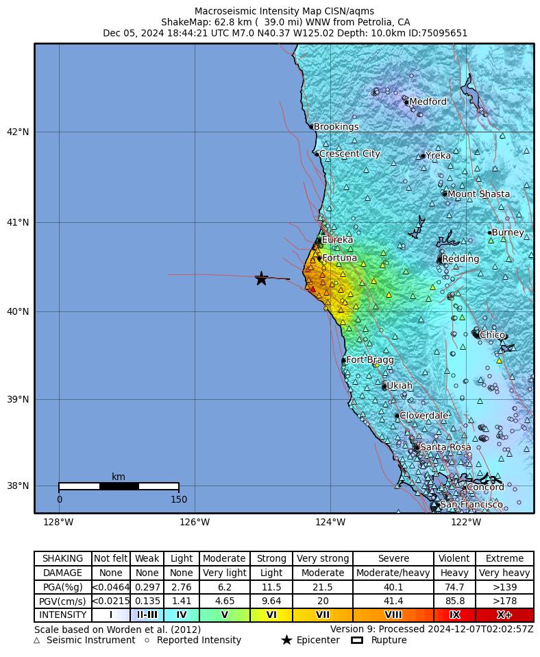
The most recent major quake in these waters struck Dec. 5, 2024. That magnitude 7.0 quake occurred about 43 miles (70 kilometers) southwest of Ferndale on an east-west, right-lateral strike-slip fault along the Mendocino fault, the USGS said. More than 16,000 people reported feeling it.
MendoLocal.News reported that the 2024 epicenter was about 30 miles east of last week’s quake. The outlet quoted Lori Dengler, director of the Humboldt Earthquake Education Center at Cal Poly Humboldt, as calling the 2024 quake the largest to affect the North Coast since the 1992 magnitude 7.2 Cape Mendocino earthquake. It also reported that the National Tsunami Warning Center put the coast from near Santa Cruz to central Oregon under a tsunami warning after the 2024 quake, and that the warning was canceled shortly before noon.
The USGS said the 2024 quake struck near the site of a magnitude 7.1 quake in 1923 that caused some damage and triggered a small tsunami. The most damaging quakes in the region have occurred onshore, the agency said, including a magnitude 7.2 reverse-faulting quake near Petrolia in April 1992 and a magnitude 7.2 strike-slip quake near Eureka in November 1980. Both caused extensive regional damage, and the 1992 quake triggered a small tsunami recorded in California and Hawaii.
The Petrolia and Ferndale area also had a magnitude 6.2 quake on Dec. 20, 2021, and a magnitude 6.4 quake exactly a year later, the USGS said.
Offshore Quakes Through the Weekend
Smaller quakes followed last week’s event elsewhere along the offshore boundary, though the USGS did not describe them as aftershocks.
A magnitude 3.1 quake struck about 130 miles (210 kilometers) west of Port Orford, Oregon, at 7:57 p.m. PST Thursday, Nov. 5. A magnitude 4.4 quake hit far off the Oregon coast at 11:20 a.m. PST Sunday, Nov. 8, and drew one felt report. At 8:49 p.m. PST Sunday, a magnitude 3.8 quake struck about 153 miles (246 kilometers) west of Ferndale.
The activity is part of a busy stretch. A USGS catalog search of the area from latitude 39.5 to 44.5 degrees north, between the coast and 130 degrees west, found 25 quakes of magnitude 2.5 or greater since Oct. 10. They included a magnitude 4.6 quake about 129 miles (208 kilometers) west-southwest of Pistol River, Oregon, at 3:26 p.m. PDT Oct. 24, and a dozen quakes of about magnitude 2.7 to 3.1 located relative to Petrolia, most of them offshore.
One of the few close to land was a magnitude 3.0 quake about 9 miles (14 kilometers) southeast of Petrolia at 6:43 p.m. PDT Oct. 21, which drew 13 felt reports. A magnitude 2.9 quake about 18 miles (29 kilometers) west of Petrolia at 6:56 a.m. PDT Oct. 30 drew one.
Aftershock Odds
The USGS aftershock forecast for the Nov. 4 quake, updated at 8:56 p.m. PST Sunday, said no aftershocks of magnitude 3 or greater had been recorded since the main shock.
For the first day after the forecast was issued, the chance of a magnitude 3 or larger aftershock was 1.88%. For the week that began Sunday night, the forecast put the chance of a magnitude 3 or larger aftershock at 7.5%, magnitude 4 or larger at 0.84% and magnitude 5 or larger at 0.09%. Over the next year, the chance of a magnitude 3 or larger aftershock was 22.41%, magnitude 4 or larger 3.16% and magnitude 5 or larger 0.33%, the forecast said.
The USGS listed no felt reports for Sunday night’s magnitude 3.8 quake as of early Monday, and it did not report damage from any of the weekend’s offshore quakes.
