Major Hurricane Willa, the once Category 5 hurricane, will strike the west coast of Mexico today with 130mph sustained winds; some of it’s moisture and energy will influence a developing nor’easter on the U.S. East Coast this weekend. A complicated, albeit not very rare, weather scenario will unfold over the next several days, sending the Pacific storm system’s remnants into the Gulf of Mexico and the U.S. East Coast.
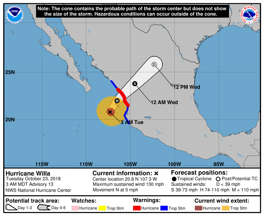
As of the latest advisory from the National Hurricane Center, the center of Major Hurricane Willa was located near latitude 20.8 North, longitude 107.3 West. Willa is moving toward the north near 5 mph. A turn toward the north-northeast is expected later this morning, followed by a faster motion toward the northeast by this evening. On the forecast track, the center of Willa will move near or over Las Islas Marias later this morning and afternoon, and make landfall within the hurricane warning area along the west-central coast of mainland Mexico later afternoon or this evening. Maximum sustained winds have decreased to near 130 mph with higher gusts; even so, Willa is an extremely dangerous category 4 hurricane on the Saffir-Simpson Hurricane Wind Scale. While gradual weakening is forecast today, Willa is expected to be a dangerous major hurricane when it reaches the coast of Mexico. According to the National Hurricane Center, hurricane-force winds extend outward up to 35 miles from the center and tropical-storm-force winds extend outward up to 125 miles. The estimated minimum central pressure is 945 mb or 27.91 inches.
After landfall tonight, Willa is expected to undergo a period of rapid weakening as it moves across Mexico towards Texas. By Thursday, Willa should no longer have any tropical characteristics tied to its remnants. However, those remnants will combine with another disturbance near the Texas Gulf coast to create a new area of low pressure.
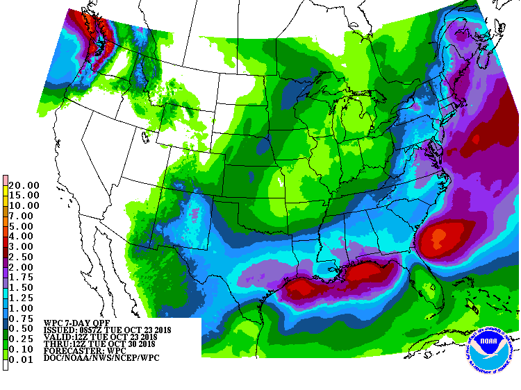
This new low pressure system is expected to intensify over time; however, it is not expected to acquire any tropical characteristics as it does so. By Thursday afternoon, wind and rain should impact the central Gulf coast including the metro New Orleans area. On Friday morning, the center of this low should be anchored near where Major Hurricane Michael impacted Florida just weeks ago, bringing unwanted wind and rain there. From Florida, the storm will hook up the East Coast, riding up the coastline to New England for the weekend.
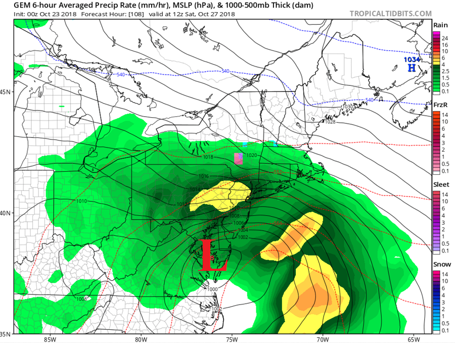
Late Friday, this system will be an intensifying coastal storm off the Carolina coast. By midnight Saturday morning, the system should be centered near Norfolk, VA, spreading rain and wind throughout the Mid Atlantic, as far north as Upstate New York and the New York Metro area, and as far west as central Ohio. The system will crawl through the Mid Atlantic coast during the day on Saturday, bringing heavy rain and wind to the region. By Sunday, the storm center will be in New England as rain and wind die off from southwest to northeast during the day.
The coastal storm could be problematic for the coast of Virginia, Delaware, Maryland, New Jersey, New York, Connecticut, Rhode Island, and Massachusetts; in these states, heavy rain, strong winds, and coastal flooding are all possible from this storm on Saturday. Heavy rain could lead to fresh water flooding inland while rough surf and beach erosion will compound coastal flood threats at the immediate shore. Wind will be strong, with occasional powerful gusts, especially at coastal communities. While this system will not be a destructive tropical cyclone, it will have the potential to knock down tree branches and wires and create power failure issues, especially in coastal areas.
With wind-whipped rain likely throughout the Mid Atlantic on Saturday and New England on Sunday, residents should begin go think about securing outdoor objects ahead of the storm. Halloween decorations and election campaign signs may blow about in storm winds.
While forecast models are aligned with how things should unfold on Saturday, model agreement degrades rapidly on Sunday, with major differences in the the orientation, depth, and progression of the longwave trough in the eastern U.S. The American GFS model lingers the low off the Mid-Atlantic coast for most of the weekend, whereas the European ECMWF blasts the low north and northwest while allowing secondary development offshore. The Canadian CMC is similar to the ECMWF but does not feature appreciable secondary low development offshore. Whether or not a secondary low forms will have a significant impact to the weather in the Mid Atlantic and New England on Sunday and Monday. As Willa’s remnants are better tracked in the United States, and more is known about energy that’ll be influencing the East Coast pattern from the West Coast, a better idea of how the complicated pattern will resolve should be known by the middle part of this week.
