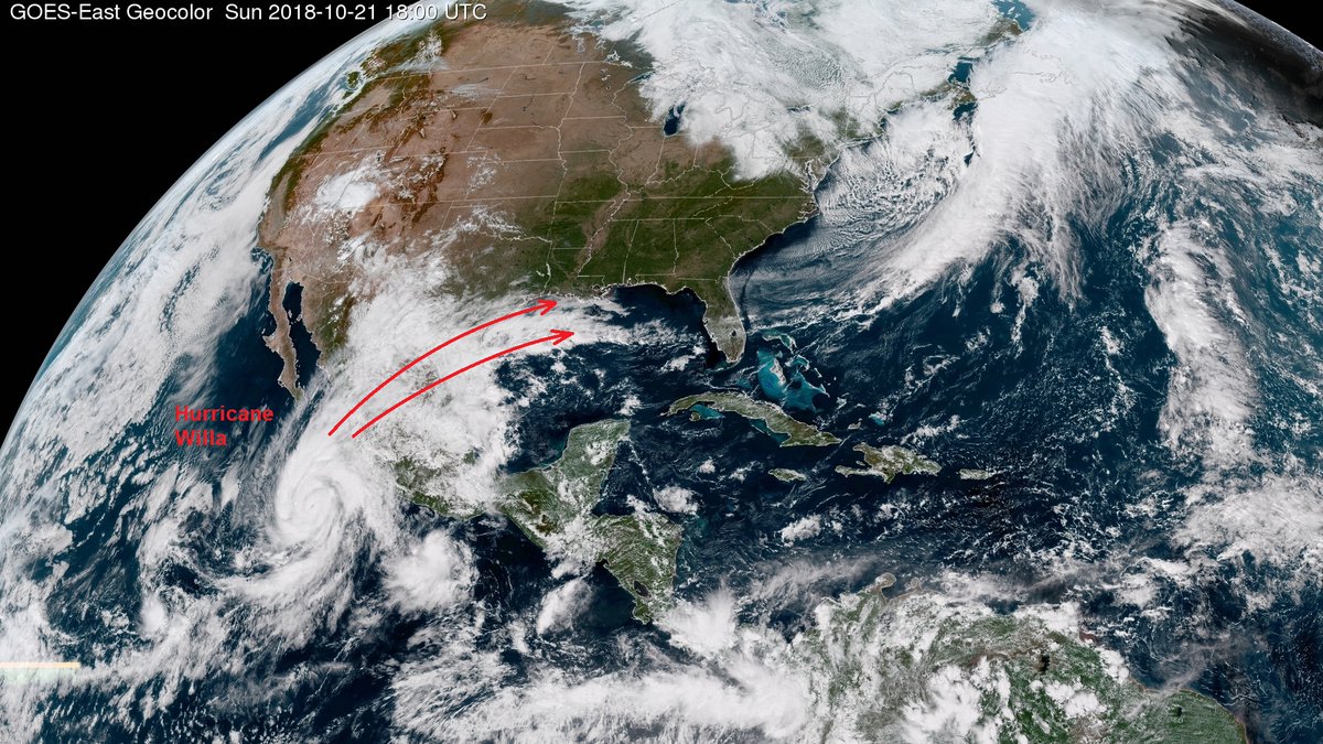
Major Hurricane Willa, a category 4 hurricane on the Saffir Simpson scale, will eventually supply moisture to a potent nor’easter on the U.S. East Coast in the coming days. Willa, which underwent explosive intensification last night, has maximum sustained winds up to 155 mph, just 2 mph shy of Category 5 strength as of the latest advisory from the National Hurricane Center. The National Hurricane Center believes it is possible Willa will reach top-of-the-scale Category 5 status; however, it forecasts that the storm will lose a little bit of punch before making landfall on the Mexican west coast as soon as tomorrow night. While a destructive landfall is expected along the Mexican coastline and life-threatening flash floods and mudslides are possible in inland Mexico, meteorologists are also tracking what’ll become the eventual impacts of this system on the United States. One such impact will occur on the U.S. East Coast, where a potent nor’easter or two is expected to form.
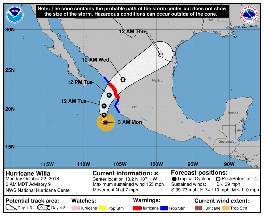
As of the last advisory from the National Hurricane Center in Miami, FL, Willa was located near latitude 18.2 North, longitude 107.1 West. Willa is moving toward the north near 7 mph , and this general motion is expected to continue today. Willa is forecast to accelerate toward the north-northeast and move over or very near the Islas Marias on Tuesday and make landfall along the southwestern coast of mainland Mexico in the hurricane warning area Tuesday night or Wednesday morning. While some weakening is forecast by tonight and Tuesday, Willa is expected to be a dangerous hurricane when it reaches the coast of Mexico late Tuesday or early Wednesday. Hurricane-force winds currently extend outward up to 30 miles from the center and tropical-storm-force winds extend outward up to 90 miles. The estimated minimum central pressure is 931 mb or 27.49 inches.
While Willa’s center of circulation, or what’s left of it, should reach the Texas/Mexico border by Wednesday night or early Thursday morning, moisture associated from the hurricane will race north and east ahead of the circulation center, combining with an old frontal boundary on the U.S. Gulf Coast. While it won’t be an organized tropical cyclone, this leftover moisture from Willa and the old frontal system on the coast will form into a better structured area of low pressure. This low will move across the Gulf Coast, bringing soaking rains to the area hit hard by Hurricane Michael just weeks ago by Thursday night.
As the system turns up the U.S. East Coast, a complicated weather scenario will unfold. While it’ll take another day or two to be sure of how things will unfold, it appears at least one and perhaps two coastal storms will impact the northeast as a result of this set-up.
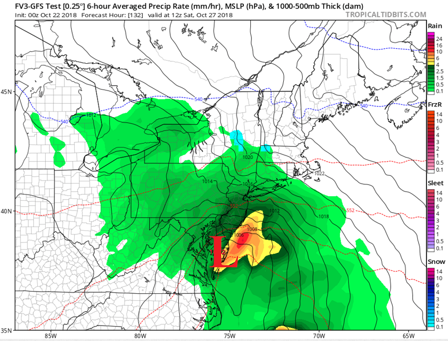
By Saturday, one piece of energy and moisture tied to this system will veer off into the Atlantic while another moves up the U.S. east coast. Shortly after midnight Saturday morning, the primary low should be near Norfolk, Virginia, spreading wind-whipped heavy rain throughout the DelMarVa Peninsula north into the New York City metro area. Rain will wrap around and push north, eventually producing very heavy rain over southeastern New England later Saturday into Sunday. Rain could be heavy at times, with 1-3″ possible over eastern Pennsylvania, New Jersey, the New York City metro area, and points south in the Mid Atlantic. For points north and east towards Boston, 2-4″ is expected, with some 3-6″+ rainfall amounts possible over Cape Cod and nearby coastal areas of southeastern New England. While precipitation may start out as or mix with wet snow flakes on the northern fringe of this system, it should be mid enough to produce mainly rain throughout the northeast. Beyond heavy rain, there could also be threats of wind damage, beach erosion, and coastal flooding depending on how deep the low becomes and how close it travels to the coast.
Right now, it appears this primary low won’t have the chance to phase with another system swinging through the Great Lakes. If it did, the storm could even be larger and more wintry, tapping into colder air available in Canada.
Instead, it appears the other system moving in from the Great Lakes will instead spawn a secondary coastal storm, producing more wind-whipped heavy rains over portions of the Mid Atlantic and Northeast on Monday and Tuesday. Without the systems phasing together and with a lack of cold air to draw from, the second system is likely to be more wet than white, even for the higher terrain of New England. However, because conditions will be slightly colder with the second system than the first, some accumulating snow could be possible on the highest elevations. The exact amounts and areas to get snow will be determined as more data is computed in the coming days.
