Thanks to the right atmospheric ingredients coming together, March will end with snow in the Northeast. With March already colder than February for many in the northeast, this next round of snow comes as no surprise to many dealing with persistent cool weather.
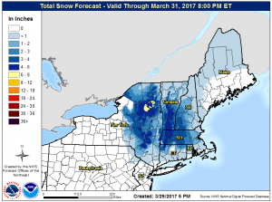
The National Weather Service in Boston has issued Winter Storm Watches ahead of this next disturbance which will produce accumulating snow, with the most snow well inland and on higher elevations of New England.
The Winter Storm Watch is up for interior northern Massachusetts north of the Mass Pike for snow, sleet, and freezing rain. According to the National Weather Service, the potential for snow accumulation of 6 inches or more with greatest risk over the higher elevations near the Route 2 corridor. Up to a tenth of an inch of ice accumulation is also possible with locally up to one quarter inch over the higher elevations.
The snow will develop Friday morning and may mix with or change to sleet and freezing rain Friday night. Precipitation will be heavy at times late Friday and Friday night. During that time, snow and ice will make for hazardous travel. The accumulation of wet snow and/or ice on trees and power lines may result in some power outages. In the heaviest bursts of snow, visibility may drop to 1/4-1/2 mile at times.
The National Weather Service issues a Winter Storm Watch when there is a potential for significant snow, sleet, or ice accumulations that may impact travel.
