• Skip to primary navigation
  • Skip to main content
  • Skip to primary sidebar

Weatherboy

Weatherboy Weather News, Maps, RADAR, Satellite, and Forecasts.

  • Local
  • Earth Science News
  • RADAR
  • Current Warnings
  • Satellite
  • Current Maps
  • Forecast Maps
  • Video

Massive Fire Burning in New Jersey Visible on Weather Satellite Imagery

by Weatherboy Team Meteorologist - June 20, 2022

A special filtered view from the GOES-East weather satellite shows a large fire burning over southern New Jersey; with northwest winds blowing over the flames, this loop shows the fire spreading to the south and east too, as indicated by the highlighted orange pixels which show a fire signature on this view. Image: NOAA


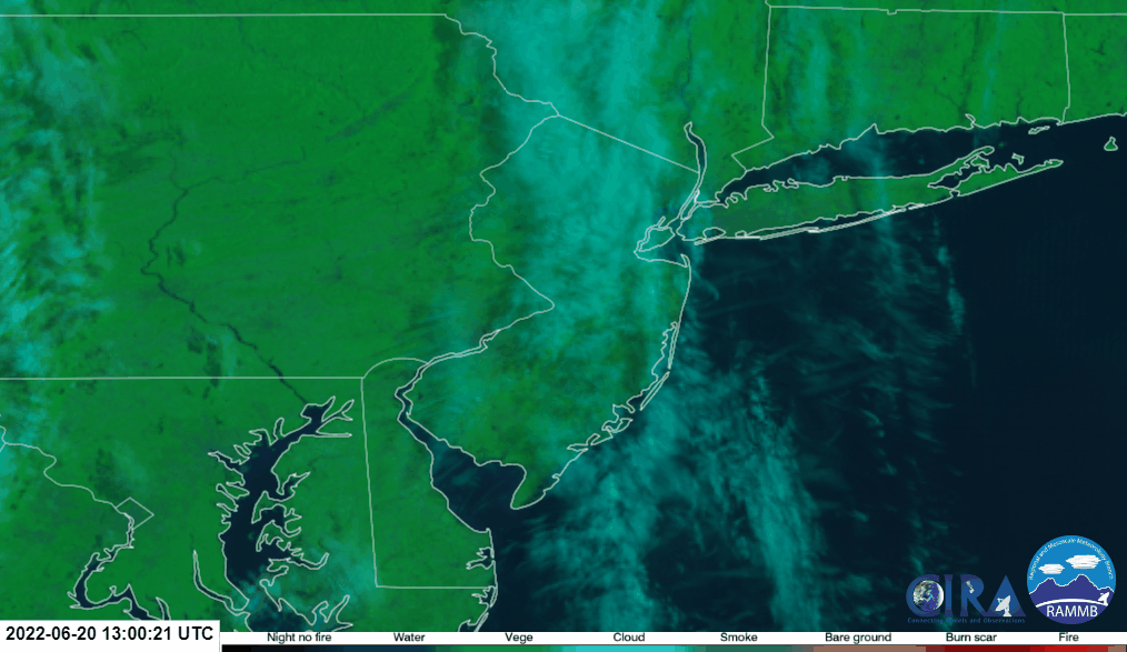
A massive forest fire burning in southern New Jersey is visible in assorted imagery being captured by the GOES-East weather satellite.

According to an update provided by the New Jersey Forest Fire Service, more than 7,200 acres has burned in Wharton State Forest, including land in Washington, Shamong, Hammonton, and Mullica Townships. As of this morning, the fire was only 45% contained.

Northwest winds are fanning the massive fire, drifting smoke which is also clearly visible in satellite photography off to the south and east of the burn zone. According to the New Jersey Forest Fire Service, crews will continue conducting backfiring operations throughout the day today to aid in containment.

The fire has forced the closures for many areas. Highway 206 is closed between Chew Road and Atsion Road; Route 542 is also closed from Green Bank Road to Columbus Road. Officials have shut down Batsto Village and all associated hiking and mountain bike trails. The Atsion  Recreation Area, the Mullica River Campground, the Lower Forde Campground, and the Mullica River Trail are all closed too and will remain closed indefinitely. Authorities have also shut down all boat launches along the Mullica River from Atsion Recreation Area to Batsto Village; as a result of those closures, Pinelands Adventures has suspended all of their kayak and canoe trips until the threat of fire has passed.


While high clouds stream overhead, thick smoke rising from a significant fire in southern New Jersey appears on this visible satellite loop, drifting south and east from the fire location. Image: NOAA

The New Jersey Forest Fire Service also says 18 structures are being threatened by the fire. Local volunteer fire departments from across Atlantic, Burlington, and Ocean Counties in New Jersey have responded, providing structure protection around those threatened areas.

Authorities also remind: “No Drones in Fire Zones – If YOU fly, WE can’t!” Because drones can interfere with fire fighting missions, they are prohibited from flying over the fiery scene.


Primary Sidebar

Sponsored Ad

Search

Latest News

  • Chief of Weather Agency Fired in Wake of Spy Balloon Drama; Second Balloon Reported Near Hawaii
  • U.S. East Coast Airspace Reopens after Military Strike Against Chinese Spy Balloon
  • Global Computer Forecast Models Keep Snow Out of I-95 Corridor through At Least Mid-February
  • Giant Spy Balloon from China Floating over Northern U.S., Forcing Airport & Airspace Closures
  • 2023 Groundhog Day Forecast In: 6 More Weeks of Winter
  • Green Comet to be Visible Tonight; It’ll Visit Earth Again in 45,000 Years
  • Today is the 20th Anniversary of Space Shuttle Columbia Disaster
  • Loud Explosions over Portions of New Jersey Likely on Saturday; Won’t be Thunder
About | Careers | Contact | Contests
Terms | Privacy | Ad Choices
Weatherboy is a (R) Registered Trademark of isarithm LLC, All Rights Reserved.
All content herein is Copyright by Isarithm LLC 1997-2022