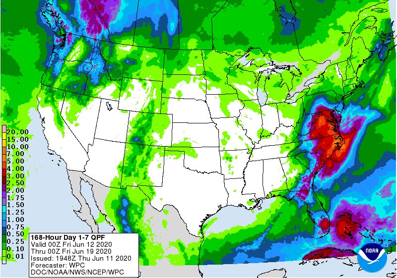
During the early part of next week, the weather pattern across the eastern United States could get “stuck”, creating a possible flood event for portions of the Mid Atlantic.
The latest precipitation analysis from the National Weather Service’s Weather Prediction Center shows an area that could see 3-7″+ rain stretching from Pennsylvania to South Carolina. Today, the National Weather Service said, “exact details on placement and magnitude are uncertain, but we are watching the potential for heavy rain and flash flooding across portions of the Mid-Atlantic and central/southern Appalachians over the next week.”
Beginning Saturday night and lingering into the middle of next week, an unsettled pattern will take root in the eastern United States. An upper low spinning across the Middle Atlantic region will set the stage for a wet scenario while surface and upper lows will drop southward towards southern Virginia and North Carolina on Tuesday and Wednesday before creeping back north on Thursday and Friday. There is substantial forecast uncertainty for next week for now; the axis of heavy rain could shift more north or south along the east coast. An abundance of clouds and showers will keep temperatures somewhat below normal across the Mid Atlantic throughout next week.
When more is known about the position and intensity of these lows, the National Weather Service will likely issue flood related advisories for portions of the East Coast. Until that happens, people in the East should know that wet weather is returning and that there could be a substantial flood threat somewhere in the Mid Atlantic next week.