• Skip to primary navigation
  • Skip to main content
  • Skip to primary sidebar

Weatherboy

Weatherboy Weather News, Maps, RADAR, Satellite, and Forecasts.

  • Local
  • Earth Science News
  • RADAR
  • Current Warnings
  • Satellite
  • Current Maps
  • Forecast Maps
  • Video

Mid Atlantic Winter Crush

by Weatherboy Team Meteorologist - February 19, 2019

Short-term, high-resolution forecast models suggest snow will fall and accumulate prior to the change-over to non-snow precipitation, making for a mess of roads in the Mid Atlantic on Wednesday. This is the projected RADAR view for lunchtime on Wednesday. Darker shades of blue indicate heavier snowfall. Image: tropicaltidbits.com


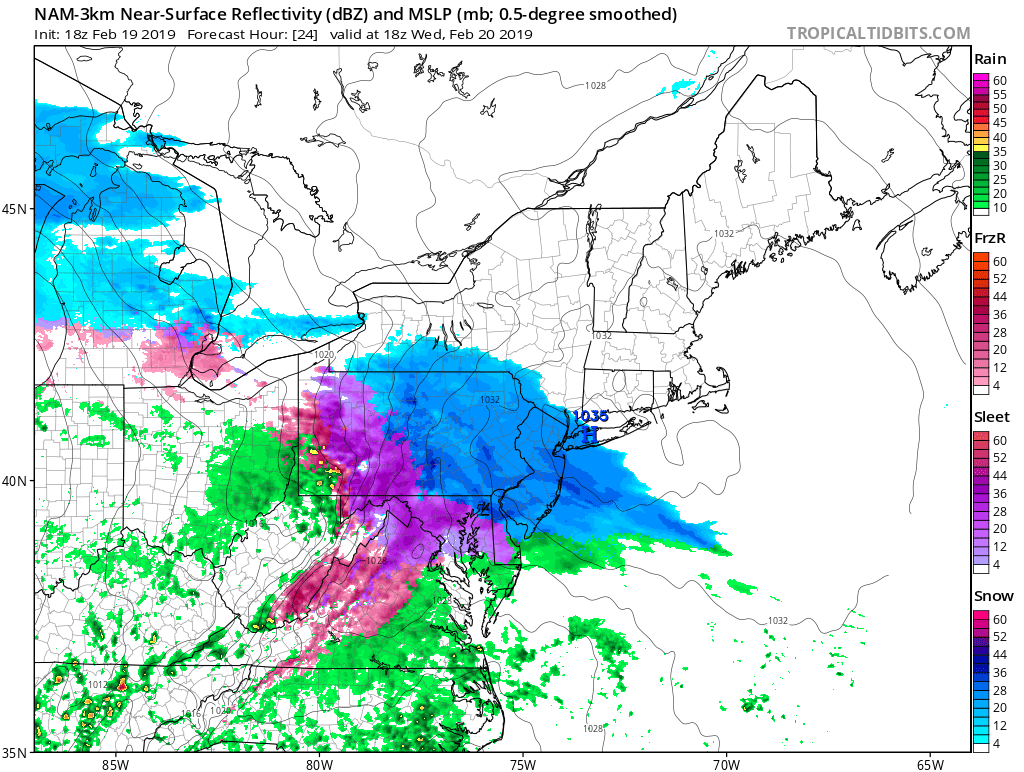
A sloppy winter storm is expected to crush travelers planning to be out and about from Washington, DC to New York City, NY with messy, hazardous driving conditions tomorrow. Overall, a snow to rain storm is expected, but accumulating snow is expected to fall at a good clip prior to the change-over during peak travel times during the day on Wednesday.


More than 6" of snow will fall over portions of the Mid Atlantic before a surge of mild air turns the snow to plain rain all the way up into the central Northeast before the storm exits. Image: weatherboy.com
More than 6″ of snow will fall over portions of the Mid Atlantic before a surge of mild air turns the snow to plain rain all the way up into the central Northeast before the storm exits. Image: weatherboy.com

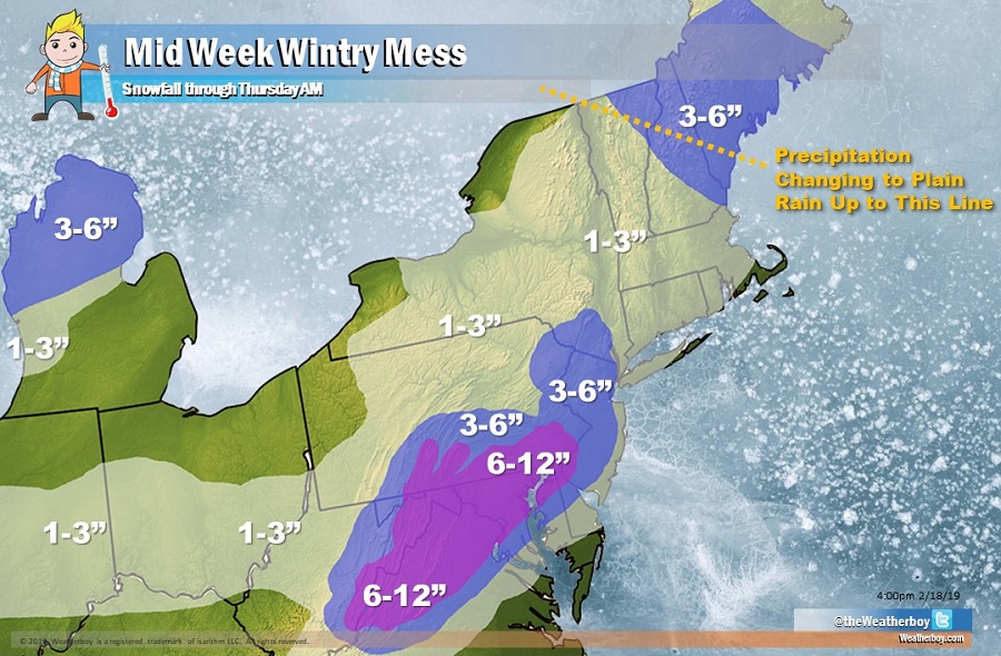
In Washington, DC, the worst of the storm will be in the morning. Snow could be moderate to heavy at times during the AM rush hour, making roads hazardous for those headed to work or school. By lunchtime, the snow will begin to transition to freezing rain and sleet. By the PM rush hour, plain rain should fall.

In Philadelphia, PA, the worst of the storm will be during the afternoon. Snow should start to fall just before lunchtime but pick up in intensity after lunchtime. Snow could be heavy at times as people begin to head out of school and work. As the PM rush hour evolves, so too will precipitation types: snow will change to an icy mix of freezing rain and sleet. By 8pm, plain rain should be falling in the City of Brotherly Love.

In New York City, NY, light snow should fall after lunchtime. Snow will pick up in intensity in time for the PM rush hour.  The snow there should change to an icy mix of sleet and freezing rain too, with all precipitation changing to all rain by 10pm at night.


With snow and ice moving into the region, the National Weather Service has issued widespread Winter Weather Advisories and Winter Storm Warnings for the storm. People are urged to use an abundance of caution if they’re out and about  during the winter weather on Wednesday.


Primary Sidebar

Sponsored Ad

Search

Latest News

  • Fiona and Ian Retired from Storm Name List; Farrah and Idris to be Added
  • Severe Weather Threat Returns to Mississippi Valley on Friday
  • Deadline for SBA Aid for Kauai Drought Coming Soon
  • Another Atmospheric River Event Slams into West Coast; More Epic Rain, Snow Expected
  • Anniversary of 1964 Great Alaskan “Good Friday” Earthquake and Tsunami
  • Tornado Watches, Warnings Issued as Severe Weather Impacts Louisiana, Mississippi, Alabama, & Gerogia
  • After Violent Night, Storms Shift to Ohio and Pennsylvania
  • Preliminary NTSB Report Shows Something other than Turbulence Killed Passenger on New England Flight
About | Careers | Contact | Contests
Terms | Privacy | Ad Choices
Weatherboy is a (R) Registered Trademark of isarithm LLC, All Rights Reserved.
All content herein is Copyright by Isarithm LLC 1997-2022