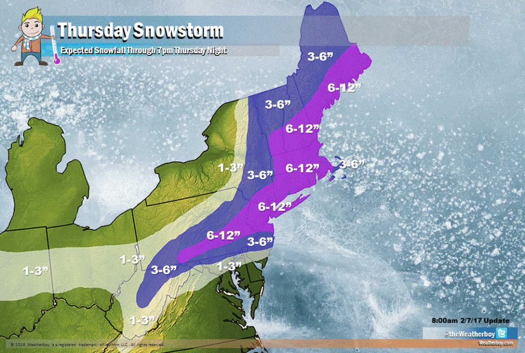
A very mild Wednesday is about to be followed by a significant snowstorm on Thursday in the northeastern United States, providing millions with a true meteorological roller coaster experience. A wide area of 6-12″ is expected even though temperatures are forecast to surge into the 50s and 60s across the northeast. As an example, in Philadelphia, we expect a new record high temperature to be made on Wednesday followed by several inches of snow on Thursday.
Low pressure near Chicago this morning anchors a warm front that extends east towards the Mid Atlantic. Tomorrow, this low pressure system will move northeast into Quebec, Canada , drawing the warm front north into the northeastern United States. This warm front will help push a very mild air mass rather far up the east coast, setting the state for high temperature records to be shattered in parts of Pennsylvania, New Jersey, Maryland, and Virginia. This same warm front will push rain, freezing rain, and snow into New England; the rain/snow line from this initial low will actually push into Canada north of the US/Canada border.
As that low pressure system continues its march north and east into Canada, a cold front behind the system will help bring much colder air into the northeast and Mid Atlantic. On Wednesday, a new area of low pressure will develop along this cold front over southern Virginia during the evening hours, intensifying as it heads off the Mid Atlantic coast as Thursday approaches.
On Thursday, this low pressure system is forecast to have just the right ingredients and atmospheric support to develop a robust snowstorm for portions of the northeast. Places getting rain Wednesday afternoon and evening in Pennsylvania and New Jersey will see a transition to plain snow on Thursday morning; some snow could become heavy at times, especially between 6am and 1pm along the I-95 corridor between Philadelphia and New York City and between 1pm and 6pm between New York City and Boston.
Unlike the last significant snow event in January that brought heavy snow to southern New Jersey, the DelMarVa Peninsula, and the Norfolk/Virginia Beach area, snow from this system will be farther north. We expect little to no snow accumulation for Cape May County in New Jersey, the southern two-thirds of Delaware, and much of eastern Maryland. Northern Virginia will be brushed by light snow as will the higher terrain of West Virginia and the mountains of western North Carolina. We expect an inch or two to fall in the northern suburbs of Washington, DC and Baltimore, MD.
Heavier snow is expected across central New Jersey into much of southeastern Pennsylvania and along the Maryland/Pennsylvania border. This area of 3-6″ of snow will stretch back into central Pennsylvania, the mountains of central West Virginia, and into upstate New York east of Route 209 and along I-87 and all points east. We expect 3-6″ to fall in Philadelphia, with lower amounts near the international airport and greater amounts near King of Prussia and points north and west.
The heaviest snow will fall over portions of central Pennsylvania, New Jersey along and north of I-195, the New York City metro area, Long Island, almost all of Connecticut, Rhode Island, and Massachusetts (except for the Cape and nearby Islands where less is expected), southern New Hampshire and Vermont, and southeastern Maine. For New Brunswick, Woodbridge, Newark, Warren, and Summit in New Jersey, we expect amounts in the 6-10″ range; for Manhattan, Staten Island, Long Island and New York City airports, we expect 6-9″; for Stamford, Hartford, Providence, and Boston, we expect 6-10″.
High pressure will build back into the region by Friday, with another warm-up expected over the weekend.