As is usually the case during the winter, there’s a single model run indicating the potential for a future blizzard in any given moment at any given time. There are a variety of forecast models meteorologists use to aid in their forecasts; throughout the day, there are more than a thousand possibilities sketched out by these models that depict how different levels within the atmosphere could be behave at some point in the future. Because there are so many models, so much output, and so many variables at play, it is unlikely any specific model run is 100% accurate, especially many days into the future.
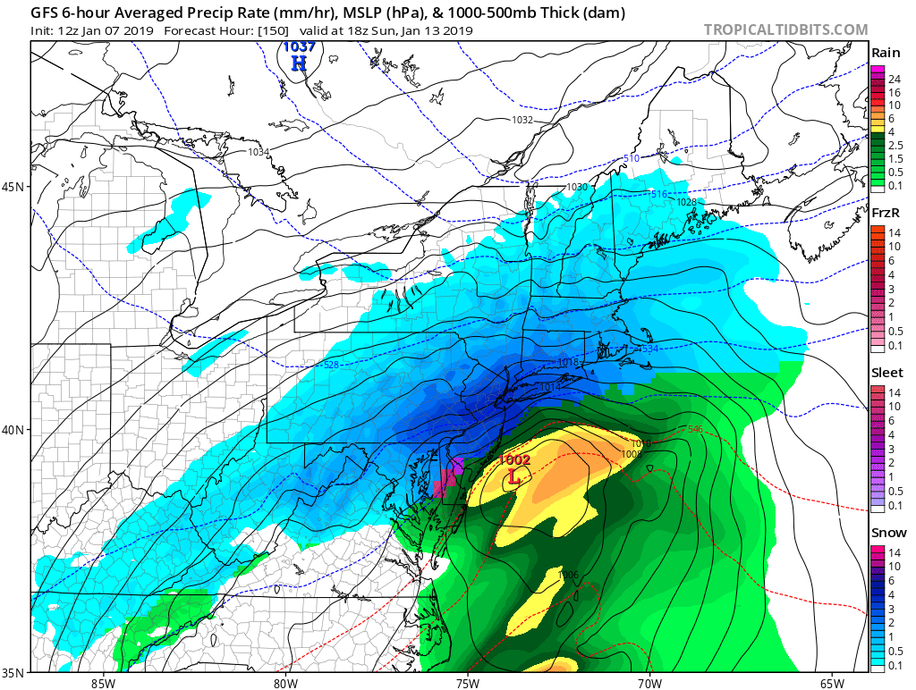
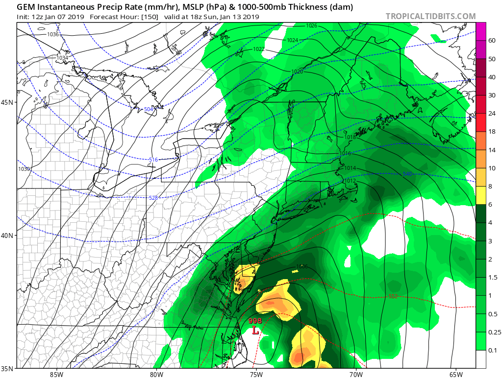
While the afternoon run of the American GFS model is calling for snow, it remains an outlier with its own prior runs and other models that provide forecast insight. Based on that and the general pattern we find ourselves in, it is not likely the American GFS is correct with its solution for next weekend at this time.
Meteorology is not modelology: while advances in global forecast models and high-resolution short-duration mesoscale models have improved in their accuracy as computing power and software upgrades have boosted performance, they still can’t replace the skill of a trained meteorologist in understanding the weather pattern and the ingredients at play in an evolving storm system.
The two most popular global forecast models include the American GFS and the European ECMWF. Both use global data that is captured twice a day by weather balloons launched around the world; they also incorporate data that comes in from geostationary and polar orbiting weather satellites high above the Earth.
The GFS is produced by NOAA’s National Centers for Environmental Prediction, known as NCEP for short. The GFS uses a base horizontal resolution of 18 miles between grid points, which is used by operational weather forecasters to a period of 16 days out. Considered a “coupled model”, the GFS output is composed of four separate models that explore the atmosphere, the ocean, land/soil, and sea ice. NCEP will regularly upgrade computer forecast models; the latest upgrade, known as FV3, is being tested now. The ongoing partial government shutdown is interfering with this test and the expected roll-out of this finalized upgrade is now delayed indefinitely.
Receiving inquiry about the 07.0z GFS model forecast blizzard next Sunday, 5+ days out. Simply put, an outlier compared to most forecast guidance, differing from its own ensemble mean. Plus poor run-to-run consistency, an extreme that we’re not trusting at this time. pic.twitter.com/xMkwN3CwDo
— NWS Boston (@NWSBoston) January 7, 2019
The European Centre for Medium-Range Weather Forecasts releases their own model, the ECMWF, known as the “Euro” for short. While the GFS makes general assumptions about general topography, the ECMWF model is nonhydrostatic. By incorporating detailed topography information into the model, the Euro model uses altitude and accurate topographic insights to generate more detailed forecasts. Nonhydrostatic models are more computationally expensive, which is why the ECMWF is the only global nonhydrostatic model used for operation meteorology at this time.
For now, the American GFS model runs four times a day while the European ECMWF model runs twice a day. An upgrade to the ECMWF system will yield four daily runs in the near future.
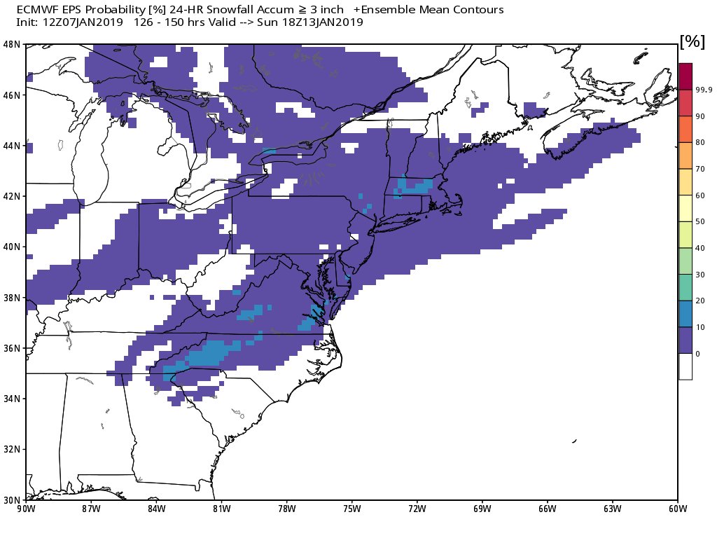
The model runs yield mountains of data, various maps, and depictions of conditions at the surface and at different layers of the atmospheres. Each run includes different sets of outputs too. Instead of producing a single forecast of the most likely weather, a set of forecasts is produced. This set of forecasts, also known as an ensemble, produces multiple simulations with multiple potential outputs. The different solutions are created to account for the two usual sources of forecast error due to the incorporation of bad data or imperfect initial conditions and errors introduced because of imperfections in the model formulation, such as the approximate mathematical methods to solve the equations.
Trained meteorologists explore all of this model data while also studying the current regional and global weather pattern and general climatology for the area. While sometimes storms will stray from climatological norms and sometimes weather patterns will be atypical, weather does follow cycles and patterns that meteorologists can recognize and leverage in their forecasting.
If multiple forecast models and forecast runs paint a similar picture of how the environment will evolve, confidence in such output and the general forecasts released by meteorologists increases too. However, in a situation like today’s, where a single model is forecasting a scenario that it wasn’t earlier and other models aren’t agreeing with, confidence in such output is low.
Meteorologists at the National Weather Service are also dismissing the idea of a weekend blizzard for now too. In Boston, they Tweeted that an earlier model run is “an extreme that we’re not trusting at this time.”
Until the modeled solutions better represent the current weather pattern we’re in and/or become better aligned with each other run and each other model solution, confidence that a blizzard will materialize will be low.
