Image: GreenGlass1972/Wikimedia Commons
A minor earthquake rumbled through northern Utah on Saturday evening, startling residents along the northern Wasatch Front who described a brief, quiet jolt that felt like a heavy truck passing by. No damage or injuries were reported.
The magnitude 3.4 earthquake struck at 6:40 p.m. MST Saturday about 7 miles southeast of Huntsville, a small town in the Ogden Valley east of Ogden, according to the U.S. Geological Survey. The USGS put the time at 01:40 UTC Sunday, Nov. 15, which was 7:40 p.m. CST Saturday.
The quake was centered at a depth of about 5.4 kilometers, or about 3.4 miles, the USGS said. The agency lists its magnitude as 3.42 on the local magnitude scale, and a seismologist has reviewed the event.
The University of Utah Seismograph Stations, which monitors earthquakes in the state for the USGS-led Advanced National Seismic Network, classified it as a minor earthquake.
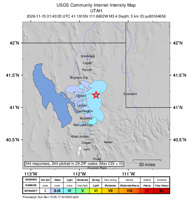
Image: U.S. Geological Survey
Felt from Ogden to Salt Lake City
By early Sunday, 344 people had submitted reports to the USGS “Did You Feel It?” website, with responses plotted in 29 ZIP codes. The strongest community shaking intensity reported was III, or weak, on the Modified Mercalli Intensity scale, according to the USGS.
Most of the reports came within the first hour after the quake, a USGS chart of responses shows. Reports came from communities including Ogden, Layton, Farmington and Bountiful, with scattered reports from Salt Lake City, according to the USGS map.
A ShakeMap produced by the University of Utah Seismograph Stations and distributed by the USGS estimated maximum shaking of about 3.6 on the intensity scale near the epicenter, which falls between weak and light shaking. At those levels, shaking is felt by people indoors but damage is not expected.
The Utah Division of Emergency Management said in a social media update that it was hearing from people who felt the quake in Ogden, east Layton and Syracuse and as far south as Fruit Heights, Gephardt Daily reported. The division noted that an earthquake of that magnitude can go unnoticed even by people living nearby, the outlet reported. It also credited university seismologists with refining the location of the epicenter.
The number of reports grew quickly. About half an hour after the quake, KUTV reported that two people had reported feeling light shaking on a USGS map. More than 310 reports had been received by 9:15 p.m., Gephardt Daily reported, citing the university.
The USGS “Did You Feel It?” system collects reports from people who experienced an earthquake and uses them to map how strongly shaking was felt in each community. Of the 344 responses, 244 had been plotted on the map across 29 ZIP codes as of early Sunday, the USGS map shows.
Ogden resident KayDee Driggs told ABC4 that the shaking “didn’t feel violent, it was very quiet and eerie, almost like a huge truck was driving down the road.”
“I didn’t know if it was an earthquake, so I ran upstairs,” Driggs said. “My husband was in the shower, I was like ‘did you feel that?'”
Another Ogden resident, Justyn Ramirez, told the station he first thought a car was driving by. “And then shortly, right after that, there was maybe two seconds of shaking, and I was like ‘oh, there’s an earthquake,'” Ramirez said.
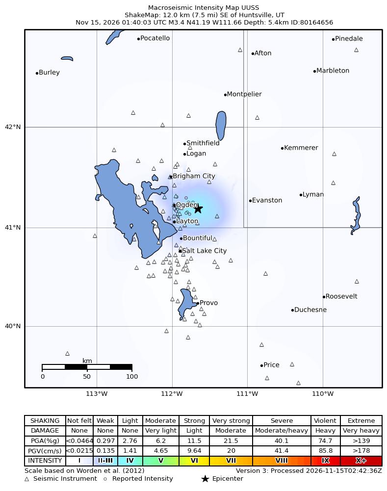
Image: University of Utah Seismograph Stations/U.S. Geological Survey ShakeMap
Location Revised After Initial Report
Early reports about the earthquake’s location varied. ABC4 reported that the USGS initially placed the quake near Enterprise before revising the location to near Huntsville.
A press release posted by the University of Utah Seismograph Stations at 7 p.m. MST Saturday described the epicenter as about 7 miles northwest of Huntsville. However, the coordinates published by the USGS, 41.19 degrees north and 111.66 degrees west, place the epicenter southeast of Huntsville, and the USGS event page and the university’s ShakeMap both describe the location as southeast of the town.
The USGS event summary lists the location as 11 kilometers, or about 7 miles, southeast of Huntsville, and the ShakeMap lists it as 12 kilometers, or 7.5 miles, southeast. The epicenter is about 16 miles east of Ogden and about 32 miles north-northeast of Salt Lake City.
No Aftershocks Recorded
As of about 6:30 a.m. CST Sunday, the USGS earthquake catalog showed no other earthquakes within about 19 miles of the epicenter since the magnitude 3.4 quake. The only other event in the catalog in that area this month was a magnitude 1.1 quake near Morgan on Nov. 4.
The university said that since 1981 it has located 73 earthquakes of magnitude 2 or greater within 15 miles of Saturday’s epicenter. The largest was a magnitude 3.7 earthquake on Aug. 30, 2023.
The university’s press release said more than 130 felt reports had been submitted shortly after the quake. That number more than doubled overnight, according to the USGS. The university encouraged anyone who felt the earthquake to fill out a survey on the USGS website.
A Reminder of Utah’s Earthquake Risk
Saturday’s quake was small, but it struck in one of the most seismically active and densely populated parts of the Intermountain West.
According to the University of Utah Seismograph Stations, about 80% of Utah’s 3.4 million residents live in the Salt Lake City-Provo-Ogden-Logan urban corridor, “literally adjacent to the Wasatch Fault.” Studies of past ruptures have found evidence of at least 20 earthquakes of about magnitude 7 along the central segments of the Wasatch Fault in the last 6,000 years, the university said.
Seismic hazard in Utah is highest along the north-south Intermountain Seismic Belt, though significant earthquakes occur throughout the state, according to the university.
Earthquakes of Saturday’s size are not unusual in Utah. In a typical year, the university locates more than 1,500 earthquakes in the Utah region, including about one in the magnitude 4 range, 12 in the magnitude 3 range and 130 in the magnitude 2 range, with about 20 reported as felt, it said.
The university operates a network of 209 seismic stations to monitor earthquakes in Utah and routinely produces ShakeMaps for events larger than magnitude 3, it said. Its 2026 news releases have included a magnitude 3.6 earthquake near Kanosh in April and a magnitude 4 earthquake near Hanksville in March.
Emergency officials recommend that people who feel shaking drop to their hands and knees, take cover under sturdy furniture and hold on until the shaking stops.
