• Skip to primary navigation
  • Skip to main content
  • Skip to primary sidebar

Weatherboy

Weatherboy Weather News, Maps, RADAR, Satellite, and Forecasts.

  • Local
  • Earth Science News
  • RADAR
  • Current Warnings
  • Satellite
  • Current Maps
  • Forecast Maps
  • Video

Quake Rattles Atlantic Northeast of Puerto Rico; No Tsunami Threat

by Weatherboy Team Meteorologist - March 9, 2021

The earthquake struck early today northeast of Puerto Rico over open water. Image: USGS


Just one day after 9 quakes rattled Puerto Rico, a stronger earthquake occurred early this morning north and east of the island and north and west of the U.S. Virgin islands, prompting the National Weather Service’s Tsunami Warning Center to issue a statement.

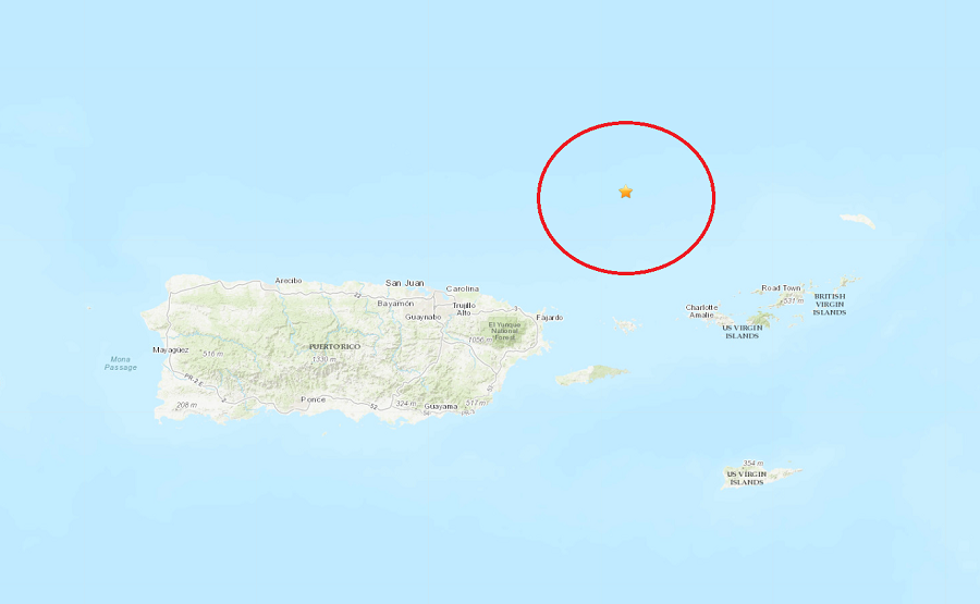
The 12:44am earthquake struck at 18.8335 North 65.292 West at a depth of 23 km; it was measured to be a magnitude 4.8 earthquake, the strongest earthquake to strike the region yet this month. While the epicenter was under water,  more than 200 people used the “Did you feel it?” tool on the USGS website to report feeling the earthquake in Puerto Rico and the Virgin Islands. The closest city to the epicenter was Culebra, Puerto Rico which is 42 miles to the south of the quake.

The National Weather Service’s Tsunami Warning Center, based on Ewa Beach on the Hawaiian island of Oahu, issued a statement that “based on all available data, there is no tsunami threat to Puerto Rico, the U.S. Virgin Islands, or the British Virgin Islands from this earthquake.”


The second CaribeWave simulation earthquake will trigger a tsunami that'll radiate out from the Northern Greater Antilles. During a real tsunami, such a map would only be made available to officially designated Tsunami Warning Focal Points and National Tsunami Warning Centers. Image: NOAA
The second CaribeWave’21 drill  simulation earthquake will trigger a tsunami that’ll radiate out from the Northern Greater Antilles. During a real tsunami, such a map would only be made available to officially designated Tsunami Warning Focal Points and National Tsunami Warning Centers. Image: NOAA

Puerto Rico is on the northern edge of the Caribbean Plate which is running into the North American Plate. The island is actually inching its way closer to the U.S. Mainland, although it’ll take thousands upon thousands of years to make a noticeable shift in its location.  Puerto Rico has seen many earthquakes in recent days in the seismic hotspot: beyond 52 earthquakes were recorded in the last 7 days, 302 in the last 30 days, and 6,310 in the last 365 days.

Puerto Rico is also participating in an earthquake and tsunami drill known as CaribeWave’21 in the coming days. However, if there’s a strong earthquake or active tsunami threat, the drill will be canceled. CaribeWave’21 and LANTEX21 drill, which is scheduled a week later,  will simulate nearby major earthquakes and earthquake-triggered tsunamis.


Primary Sidebar

Sponsored Ad

Search

Latest News

  • Winter Storm to Bring 4″+ Snow to Hawaii Today
  • NASA to Hold Special Media Event Wednesday to Discuss Interstellar Mystery Object 3I/Atlas
  • Overnight Earthquake Rattles Kentucky Southeast of Cincinnati, Ohio
  • Comet C/2025 K1 (Atlas) Splits Up While Interstellar Object 3I/Atlas Continues to Puzzle Scientists
  • Sun Launches Powerful X Class Solar Flare – Again!
  • After Violent 48 Hours, Earth’s Atmosphere Returns to Normal After Geomagnetic Storm
  • IMPACT! CME Arrives on Earth, Geomagnetic Storm Building; Expected to be SEVERE
  • SEVERE Geomagnetic Storm (G4) Now Expected November 12
About | Careers | Contact | Contests
Terms | Privacy | Ad Choices
Weatherboy is a (R) Registered Trademark of isarithm LLC, All Rights Reserved.
All content herein is Copyright by Isarithm LLC 1997-2022

Insert/edit link

Enter the destination URL

Or link to existing content

    No search term specified. Showing recent items. Search or use up and down arrow keys to select an item.