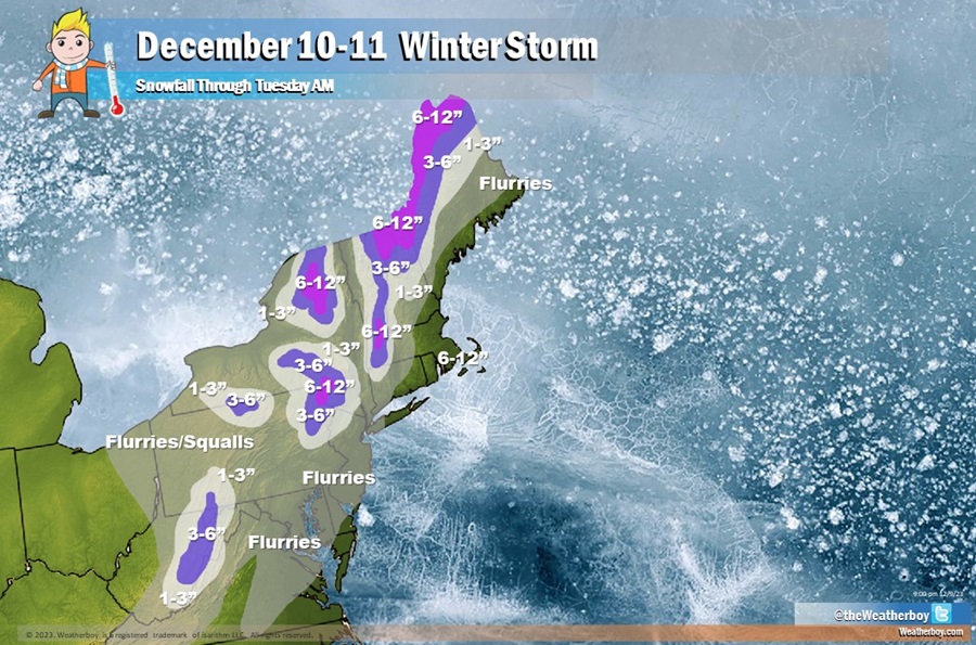
A storm system bringing soaking, flooding rains and strong, damaging winds to portions of the East Coast today will wrap up as an accumulating snowstorm in the Northeast on Monday. Rain will change to snow in many areas across the northeast; far north and west of the I-95 corridor, the snow will accumulate, with upwards of 8-12″ expected across portions of New York, Vermont, New Hampshire, and Maine.
Closer to the I-95 corridor, rain may quickly change to snow before ending. Taking on in the form of flurries across the New York City and Philadelphia areas, these light snow showers won’t lead to any accumulating snow.
A stray snow shower or flurry is also possible further south across portions of Delaware, Maryland, and Virginia, including the Washington DC metro area. However, like locations up the I-95 corridor, no snow accumulations are expected.
The morning commute will be difficult for many in the northeast tomorrow. Drive with care and caution! https://t.co/Hd43uqwqa4
— the Weatherboy (@theWeatherboy) December 10, 2023
While flurries and squalls may dot the landscape in portions of the Northeast and Mid Atlantic, heavy snow will fall across portions of Upstate New York, Vermont, New Hampshire, and Maine; more than 6″ of heavy snow is expected in those areas by the time the snow wraps up Monday morning. The highest elevations may see a foot or perhaps a touch more before the snow ends. Portions of the Central Appalachians are also expected to pick up several inches of snow.
