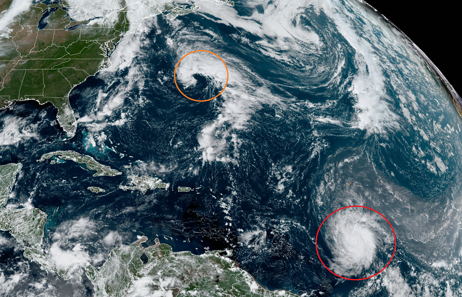
The National Hurricane Center (NHC) is expecting Hurricane Sam to enter into a period of rapid intensification shortly while another storm appears to be taking shape over the Atlantic Ocean not far from Bermuda. Both of these systems are expected to be stronger than they are now by later this evening; however, both are also not close to land, so tropical cyclone advisories aren’t needed at this time.
Hurricane Sam is located roughly 1,365 miles east-southeast of the Northern Leeward Islands. In the last update from the NHC, Sam had maximum sustained winds of 75 mph, making it a Category 1 hurricane on the Saffir-Simpson hurricane wind scale. With a minimum central pressure of 993 mb or 29.33″, it was moving due west at 14 mph.
The National Hurricane Center expects Sam to rapidly intensify over the next few days, becoming a Major Hurricane by tomorrow. Destructive Major Hurricanes have maximum sustained winds greater than 110 mph. By Wednesday, the National Hurricane Center expects Sam to have maximum sustained winds greater than 130 mph, which would make it a catastrophic Category 4 storm.
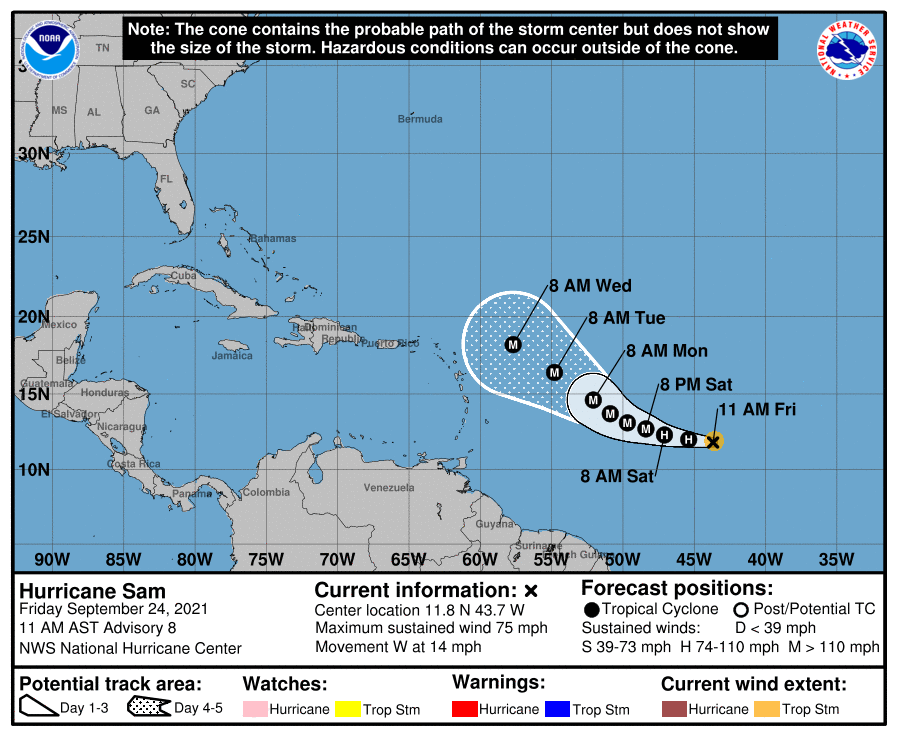
While Sam intensifies, it will also slow down its forward speed and begin to shift direction slightly. While it’s moving west now, and it is forecast to continue to move west through tonight, the NHC believes it’ll move more west-northwest starting this weekend. As it moves slightly north of west, it will also slow down. By Wednesday morning, the center of the storm should still be east of the Northern Leeward Islands.
Where it goes beyond Wednesday remains in doubt and question. Half of computer forecast models suggest impacts to the Bahamas or the U.S. East Coast while the other half suggest a turn out to sea, which would spare North America from direct impacts. The mean track would be in the middle, which could bring a damaging landfall to Bermuda. It is still too soon to say where Sam will go as September wraps up and October begins; however, it is not too soon for people on the U.S. East Coast, the Bahamas, the Caribbean, and Bermuda to review their Hurricane Action Plan and be prepared with the knowledge of what to do should Sam head their way in the coming days.

While Sam is intensifying, another system appears to be taking shape over the Atlantic Ocean too. According to the NHC, surface observations and recent satellite wind data indicate that a surface low located a couple hundred miles north-northeast of Bermuda is gradually becoming better defined as it interacts with an upper-level trough. This system is producing winds of 40 to 45 mph north of the low center and additional development into a subtropical or tropical storm appears likely; right now, the NHC believes there’s a 70% chance of cyclone formation over the next 48 hours. Because of that, the NHC says that advisories could be initiated as soon as this afternoon as the system moves slowly toward the north-northwest over the next day or so. Should this system be named, it would be called Teresa.
Elsewhere in the Atlantic Hurricane Basin, there are no other systems of concern in the tropics for the United States. No other tropical cyclones are expected to form and impact the U.S. over the next five days.
The 2021 Atlantic Hurricane Season runs through to the end of November.
