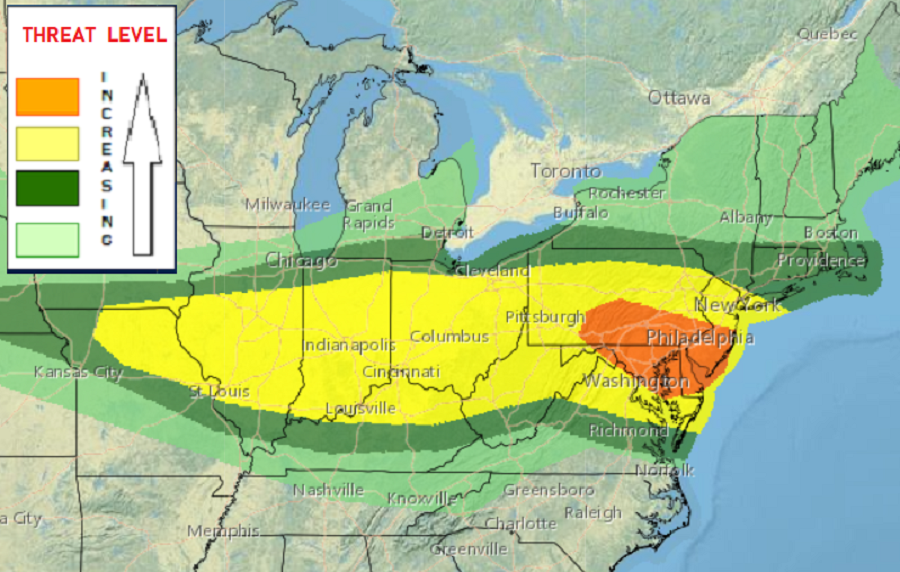
The risks of tornadoes, damaging winds, and general severe storms are on the increase today across portions of the Ohio River Valley and Mid Atlantic regions. The National Weather Service’s Storm Prediction Center (SPC) now believes there is an enhanced level of risk of severe weather across southern New Jersey, southeastern Pennsylvania, eastern Maryland, and most of Delaware; this danger zone includes Philadelphia, Baltimore, Washington DC, Arlington, and Atlantic City. This enhanced zone could also be an area where isolated tornadoes touch-down in the height of today’s expected severe weather outbreak.

The SPC says several ingredients are coming together today to create the severe weather outbreak. An upper-level pattern in the northeast can be characterized by a broad trough today. A mesoscale convective vortex responsible for severe weather overnight last night will move from the lower Great Lakes to the Mid Atlantic during the day today. While that’s happening, a warm front will advance north at the surface through the Mid Atlantic while a cold front advances southeast, reaching Pennsylvania and the central Appalachians by evening. The SPC believes the warm sector in this area will become moderately unstable during the afternoon hours. Thunderstorms are expected to develop ahead of the cold front in association with ascent attending the southeast-moving mesoscale convective vortex as well as along the southeast-advancing cold front. This area will reside within a belt of stronger mid-upper flow associated with the synoptic trough ,supporting an environment ripe for severe weather. As such, the SPC says some supercells may evolve along with line segments with bowing structures as activity develops southeast during the afternoon into the evening. The primary severe weather threats appear to be damaging wind and perhaps some hail. Unfortunately, conditions appear to be sufficient to foster a few tornadoes, especially if sufficient instability can develop in the vicinity of the warm front.
According to the SPC, the greatest risk of tornadic cells is across the southern half of Pennsylvania, northeast West Virginia, all of Delaware, most of Maryland, portions of northeastern Virginia, and the southern 2/3rds of New Jersey.
Even before severe weather strikes, people should be prepared with what they’d do should the National Weather Service issue a Severe Thunderstorm Warning or Tornado Warning for their county.
The threat of severe weather will sweep from west to east during the day, coming to a close in the early evening hours near the coast.
