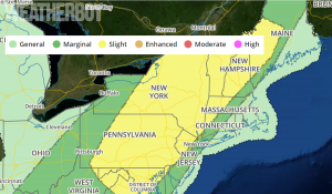
Just a week after the remnants of Tropical Storm Cindy brought severe thunderstorms with damaging winds and tornadoes to places like New Jersey, it looks like the northeast will be under the gun again with a renewed threat of severe weather. The National Weather Service’s Storm Prediction Center has issued a Convective Outlook which puts a large area near and north and west of the I-95 corridor from Virginia to Maine under an increased threat of severe thunderstorms today.
The National Weather Service defines a thunderstorm as “severe” when it contains a tornado and/or contains winds in excess of 58mph and/or contains large hail in excess of 1″ diameter. Heavy rain that cause flash floods and frequent, dangerous lightning are also possible in thunderstorms, severe or not.
The National Weather Service believes the greatest threat from today’s storms will be wind damage. While there’s an isolated chance of tornadoes, especially across northeastern upstate New York, Vermont, new Hampshire, and western Maine, there’s a wider threat area of damaging winds and pretty much mirrors where the Storm Prediction Center has colored their Convective Outlooks today as “yellow.” Large hail is also possible from some storms.
Meteorologists caution: “when thunder roars, head indoors.” Lightning can kill whether a storm is severe or not.