• Skip to primary navigation
  • Skip to main content
  • Skip to primary sidebar

Weatherboy

Weatherboy Weather News, Maps, RADAR, Satellite, and Forecasts.

  • Local
  • Earth Science News
  • RADAR
  • Current Warnings
  • Satellite
  • Current Maps
  • Forecast Maps
  • Video

Severe Thunderstorm Watch, Warnings Issued

by Weatherboy Team Meteorologist - August 7, 2019

A large, heavily populated area is under a Severe Thunderstorm Watch now through 9pm tonight. Image: NWS


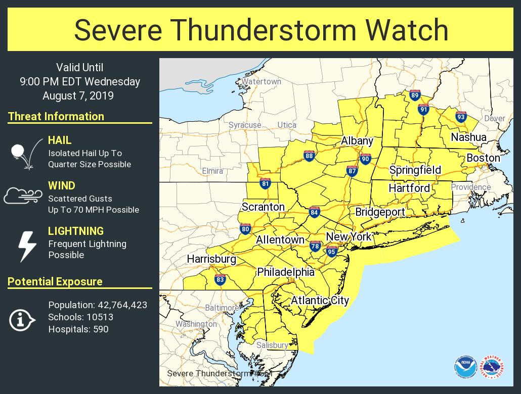
Another round of severe weather is marching through portions of the Mid Atlantic and Northeast, prompting the National Weather Service to issue a large Severe Thunderstorm Watch and numerous Severe Thunderstorm Warnings. The National Weather Service is encouraging people in a warning to move to an interior room on the lowest floor of a
building. There are numerous reports of continuous cloud to ground lightning, which on its own is a hazard. Torrential rainfall is also occurring with these storms and may lead to flash flooding.

In addition to damaging winds, large hail, and the threat of tornadoes, thunderstorms will also create abundant lightning.

While storms have fired up and prompted many warnings to be issued, another round is possible this evening, perhaps in the same areas hit hard this afternoon. Along the I-95 corridor, there could even be a brief lull in the activity this afternoon.  This will occur as a developing frontal system approaches from the west associated with a medium amplitude, progressive upper level trough. Expect strong to severe storms to develop with this feature over central Pennsylvania and Maryland.  Since the shear and forcing will be stronger later in the day, storms will be better organized and will take on a multi-cellular structure in the from of one or more line or line segments. Some of the worst storms could hit between 5pm and 1am. The primary threat will be in the form of damaging wind gusts; however, an isolated tornado cannot be ruled out.  Storms that form can also drop very heavy rain over a short period of time; as such, isolated flash flood conditions will be possible at the same time too.


High pressure will build into the northeast early Thursday, drying conditions out


Primary Sidebar

Sponsored Ad

Search

Latest News

  • Harvard Scientist Tracking 3I/Atlas Believes New Photos May Show Alien Spacecraft Engines
  • Geomagnetic Storm Watch for MODERATE Storm November 8
  • Alien Spaceship or Unusual Comet? More Demand Answers on Color/Speed/Shape Shifting Object in Space
  • 31+ Quakes Rattle Texas Today: Likely Fracking Related
  • Damaging Wind Gusts and Snow Squalls Possible in Northeast on Wednesday
  • 300+ Earthquakes Rock Caribbean, Still No U.S. East Coast Tsunami Threat
  • Atlantic Hurricane Basin Quiets with 4 Weeks of Season To Go
  • Quake Rattles Heart of New Madrid Seismic Zone in Missouri
About | Careers | Contact | Contests
Terms | Privacy | Ad Choices
Weatherboy is a (R) Registered Trademark of isarithm LLC, All Rights Reserved.
All content herein is Copyright by Isarithm LLC 1997-2022

Insert/edit link

Enter the destination URL

Or link to existing content

    No search term specified. Showing recent items. Search or use up and down arrow keys to select an item.