Another severe weather outbreak is likely Thursday in portions of the southeastern United States, just a week after another severe weather outbreak produced dozens of tornadoes in the same general area. The outbreak of severe storms could including several long-track strong tornadoes, scattered large to very large hail, and severe/destructive winds. The greatest threat will exist Thursday into Thursday evening across a portion of the lower Mississippi Valley, Tennessee Valley, and Southeast.
A storm system swinging across the midwest will be responsible for this week’s outbreak. A shortwave trough with attendant strong mid-level jet will eject northeastward from the southern Plains across the lower and mid Mississippi Valley on Thursday, and continue over the Ohio Valley and lower Great Lakes region Thursday night. At the surface, a weak low over northeast Texas Thursday morning is expected to also develop northeastward to the mid Mississippi Valley through the day while deepening. A warm front tied to this cyclone will likely lift north across the lower Mississippi Valley / Mid-South and Tennessee Valley towards the lower Ohio Valley by Thursday evening.
Storms blossoming over northeastern Texas, southern Arkansas, Tennessee, and northern Mississippi and Alabama Thursday morning will shift to the north through the morning hours, supported by a southerly low-level jet and warm air advection. As these storms shift northward through the morning, the National Weather Service’s Storm Prediction Center (SPC) says this will allow for destabilization via diurnal heating to occur across the lower Mississippi Valley, setting the stage for the outbreak.
This type of atmospheric set-up will support supercell and severe storm development. Low-level mesocyclones capable of producing strong, long-track tornadoes appear likely with any supercells that can form, according to the SPC. Scattered large hail, some of which may be 2″+ in diameter, and severe/destructive winds also appear probable, both with supercells and any bowing line segments that can develop.
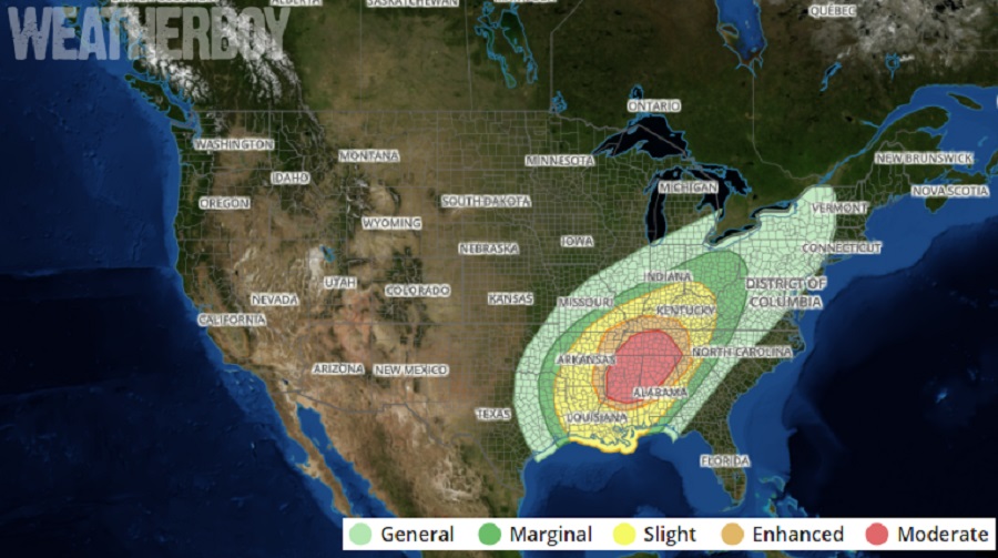
The SPC says that at this time, the best potential for strong tornadoes appears to extend from parts of
central/northern Mississippi into western/middle Tennessee and central/northern Alabama, mainly Thursday afternoon and evening as storms move generally northeastward.
People within the threat zone should know what to do when severe weather strikes well before it does. Everyone should have a way to hear/read Severe Thunderstorm and Tornado Warnings as they’re issued and take immediate action when they are issued.
