A complex area of low pressure will bring a variety of weather to the northeast later this week and into the weekend. While heavy snow is expected to the north, a messy mixed bag of precipitation is expected, where snow will change over to sleet and plain rain in many places, including along the heavily traveled I-95 corridor.
A frontal system pushing through the northeast today will help push colder, drier air into the Mid Atlantic tonight. While some scattered snow showers and snow squalls will be possible in this colder air mass through tomorrow in the northeast, the more important feature here is the presence of that cold air. This cold air will help set the stage for a widespread outbreak of snow later Friday into Saturday.

After a cold and dry Friday, a storm system will move into the Great Lakes late in the day and track east into New England on Saturday. This means a shortwave ridge will progress towards the northeast on Friday while at the surface cold and strong high pressure will move to near the New England / Canada border. A progressive but fairly potent shortwave trough and associated surface low will push these features offshore Saturday. The surface low should pass through the Great Lakes Saturday, eventually merging with a secondary low that should develop along the northeast coast. Eventually, this storm system will slide north and east off to the Canadian Maritimes by Sunday.
As precipitation slides in from west to east across Michigan, Ohio, southwestern Pennsylvania, and West Virginia on Friday, it will fall as plain snow. The same will be true when this precipitation shield moves into Maryland, Delaware, New Jersey, and points north Saturday morning and afternoon. If the coastal system were to get stronger and keep the cold air locked into the region, more snow would fall. However, it now appears that coastal low will be too weak and too far north to have too much influence on the broader system moving in from the Great Lakes. As a result of the southerly flow moving in from the Great Lakes low, temperatures will warm enough to change snow over to sleet and freezing rain.
The change-over to non-snow should occur fairly quickly on the southern side of the storm, especially over Virginia, eastern Maryland, Delaware, and New Jersey. As such, little in the way of snow accumulation is expected there prior to the changeover.
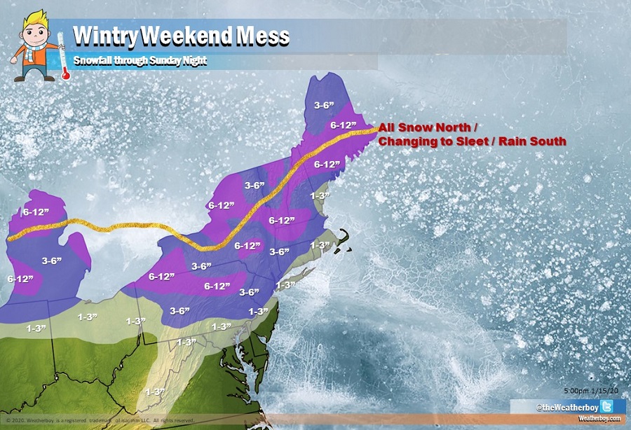
Along the I-95 corridor, though, 1-3″ of snow is likely before a changeover, with some 3-6″ amounts possible in northeastern New Jersey and southeastern Upstate New York. Most of this snow should wash-away with the rain late Saturday into early Sunday.
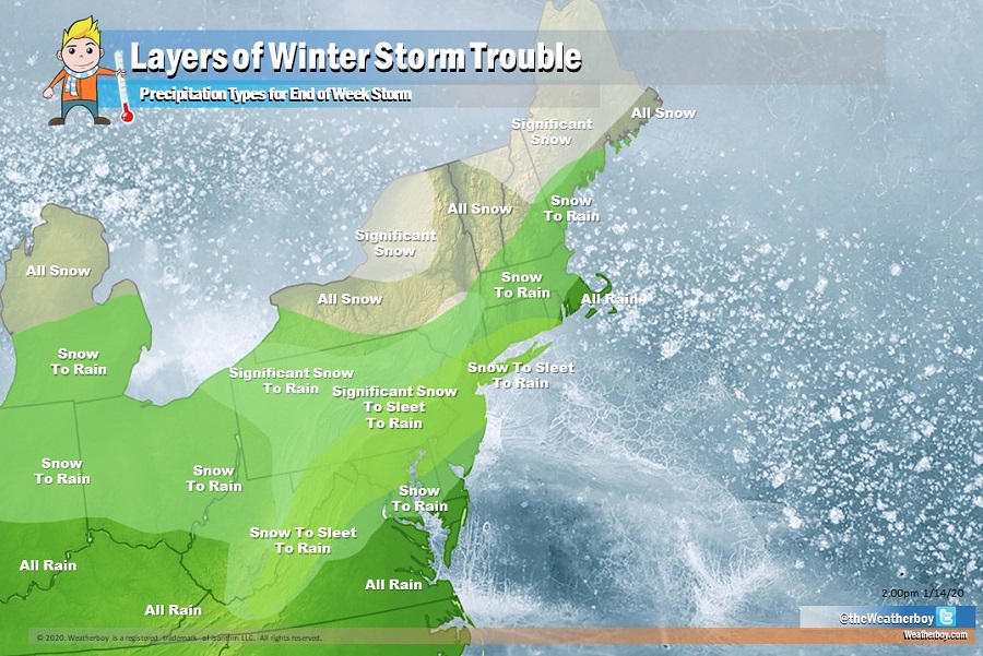
North of here, even more snow will fall, with some areas getting 3-6″ and 6-12″ amounts. But even where 6-12″ falls, a changeover to sleet, freezing rain, and plain rain is expected south of central Michigan, central New York, north-central Vermont and New Hampshire, and central Maine. South of this area, snow will become slushy, wet, and heavy. North of this area, the precipitation should remain all snow, resulting in a more powdery consistency there.
All precipitation will end from southwest to northeast by Sunday morning to afternoon, with dry, fair, and colder weather arriving. The new week will start out cold but dry.
