While portions of the northeast are digging out of the weekend storm and parts of the Mid Atlantic are preparing for the next one, it looks like the Florida Gulf coast could see some of their own snowflakes too this weekend. But this will be a wintry weather event more for cameras than for snow shovels: while snow flakes may fly, they won’t stick and no accumulations are expected.
Seeing snow around this part of Florida is very rare. According to the National Weather Service office in Tampa, the last time this occurred was January 9, 2010.
Arctic air will usher in the coldest temperatures of the year this weekend setting the stage for the snow. A Freeze Watch has been issued for Saturday night into Sunday morning and the National Weather Service says Freeze Warnings will likely be needed for the area around Tampa Bay both Saturday night and Sunday night. A hard freeze will be possible across the nature coast Saturday night and Sunday night with lows in the lower to mid 20s each night. Temperatures across the interior are expected to be in the mid to upper 20s both nights with lower to mid 30s near the coast and across southwest Florida. Gusty northwest winds will create wind chills Saturday night in the teens across the Nature Coast with single digits possible mainly across Levy and Citrus counties. Wind chills are expected to be in the teens to lower 20s across the interior and generally in the 20s elsewhere. The wind is expected to taper off Sunday night, with wind chills generally about 3 to 5 degrees below the ambient temperature.
Temperatures will be running about 20 to 25 degrees below climatic normals Saturday night through Sunday night. The National Weather Service says some record low temperatures may be set Saturday night/Sunday morning around Tampa and surrounding communities, some low max temperature records set on
Sunday, and some more record low temperatures again Sunday night/Monday morning.
Along area beaches, very strong rip currents are expected to develop Saturday through Sunday. There is also a low to moderate probability of high surf.
The strong northwest winds may also create water levels along the coast from Citrus to northern Pinellas county to run 1 to 2 feet above astronomical normal tide levels Saturday and Saturday night. This is also in the low to moderate probability of occurrence.
The strong winds and cold air advection over the coastal waters of the Gulf of America will create a very unstable turbulent boundary layer. Meteorologists at the Tampa office of the National Weather Service say residual low level moisture will likely allow an area of cold air stratocumulous to develop over the eastern Gulf of America on Saturday and Saturday night. With these extreme conditions in place, it would be expected to see a few light showers or sprinkles to develop over the coastal waters. These “Gulf effect” showers would be comparable to the “lake effect” events that occur around the Great Lakes.
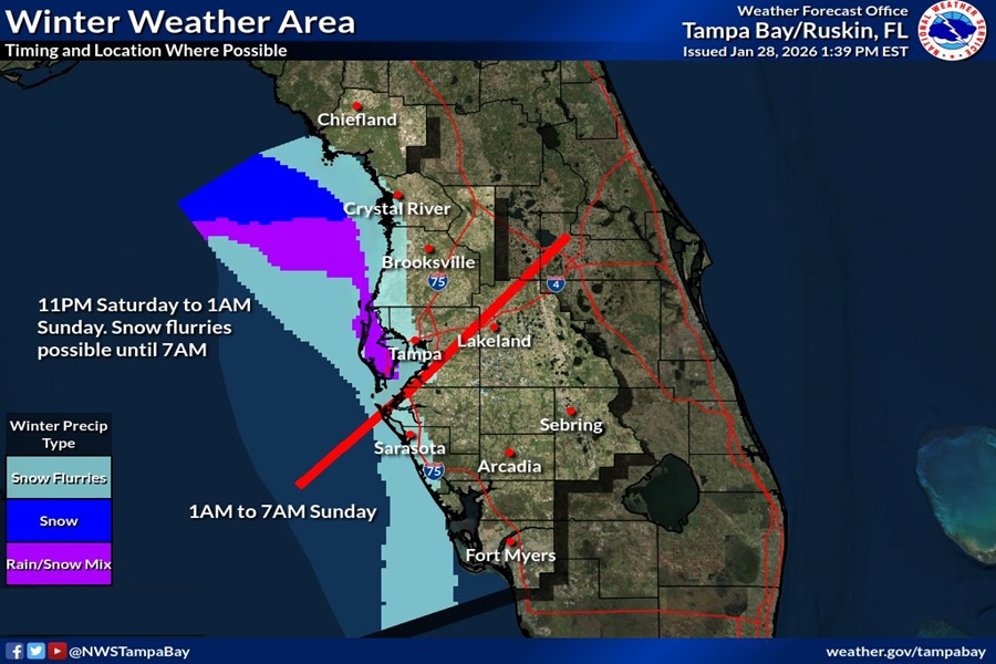
On the backside or northern extent of the cloud shield, temperatures will drop into the mid to upper 30s Saturday evening and after midnight, which could allow the light rain showers to become light mixed snow/rain showers or snow showers/flurries. Trajectories would indicate that the clouds may advect locally onshore, with the best chance of seeing frozen precipitation from Citrus to Pinellas/Hillsborough counties.
“This is a low probability event, but not out of the realm of possibility,” the National Weather Service says. “It’s common in scenarios like this that drizzle or very light rain gets reported as snow when in fact surface temperatures don’t support that possibility.”
Nevertheless, the best chance of seeing snow flakes fly will be between 11pm and 7 am Saturday night into Sunday morning for areas of Tampa and north and between 1 am to 7am for places south. While snowflakes may reach Sanibel and Captiva Islands and portions of Cape Coral, snow isn’t expected in Ft. Myers or places south.
