• Skip to primary navigation
  • Skip to main content
  • Skip to primary sidebar

Weatherboy

Weatherboy Weather News, Maps, RADAR, Satellite, and Forecasts.

  • Local
  • Earth Science News
  • RADAR
  • Current Warnings
  • Satellite
  • Current Maps
  • Forecast Maps
  • Video

Soaking Rains Continue in East

by Weatherboy Team Meteorologist - September 29, 2020

The area hatched in red could see flood concerns over the next 24 hours.  Image: NWS
The area hatched in red could see flood concerns over the next 24 hours. Image: NWS


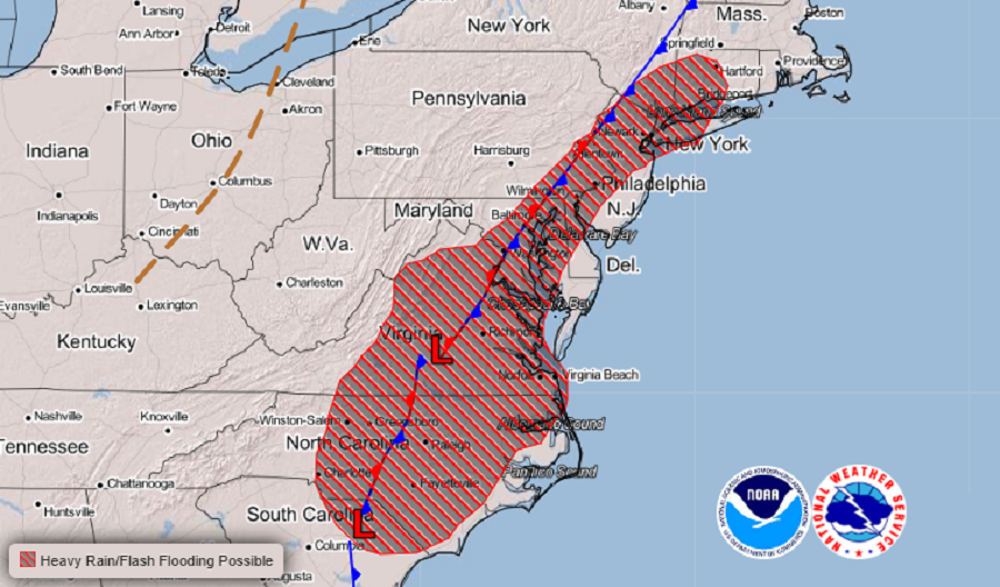
A soaking rainstorm will continue in portions of the eastern United States today into tomorrow, bringing the threat of flooding from Connecticut south to South Carolina, including the heavily traveled I-95 corridor in the Mid Atlantic. The heaviest rain should fall within 2 hours of midnight tonight.

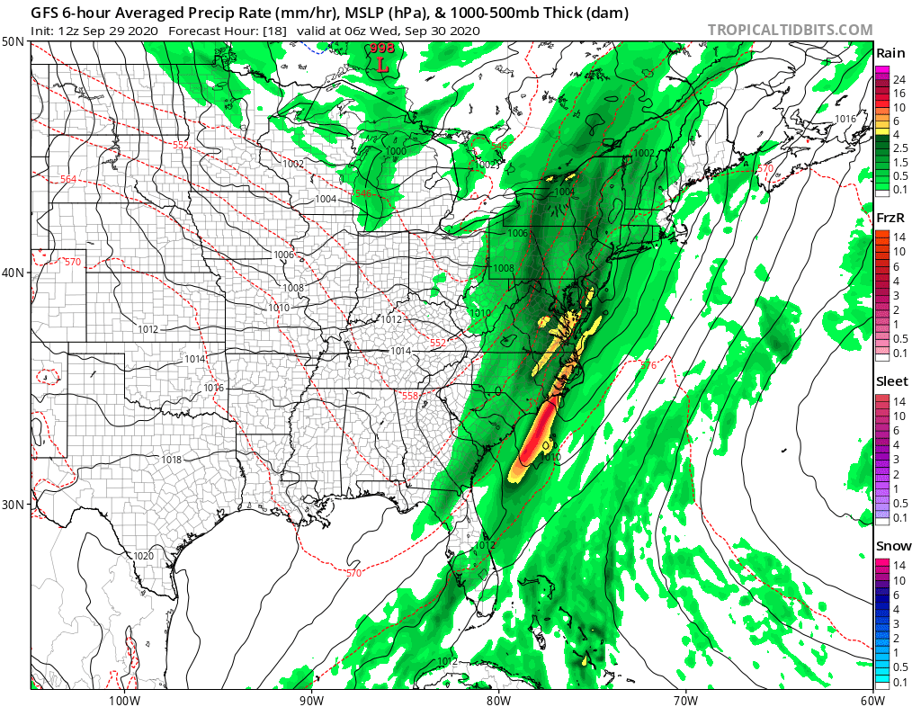
A cold front continues to move across the Mid Atlantic this afternoon and will slowly make its way across the I-95 corridor  this evening and overnight. Ahead of the front, a couple of short waves or vorticity impulses will continue to move across the region, leading to increasing showers ahead of the main front. As the front approaches, a steadier rainfall will spread across the entire area. As the front makes its way across the Mid Atlantic region, an area of low pressure is expected to develop along the front and move along it to the northeast.  Ingredients will come together to create an environment ripe for heavy rain and heavy rainfall rates over a relatively short period later tonight.


Computer modeled forecast RADAR image for around midnight tonight shows heavy rain moving through portions of the eastern United States.  Image: tropicaltidbits.com
Computer modeled forecast RADAR image for around midnight tonight shows heavy rain moving through portions of the eastern United States. Image: tropicaltidbits.com

Because it has been so dry in this region in recent weeks, widespread flooding is not a concern. However, the heavy rain will continue to create isolated and localized flooding problems, especially in urban areas or those with poor drainage. The National Weather Service reminds people in this area: “Turn around, don’t drown; never drive through flood waters.”

Due to the heavy rain in the forecast, NASA has postponed a rocket launch that was to lift-off from the Wallops Flight Facility in Virginia. That rocket launch will now launch on Thursday night, October 1.

The rain will exit the east coast from southwest to northeast tomorrow, with fair weather temporarily arriving. However, another disturbance will create more unsettled weather Friday into Saturday for the Mid Atlantic once again.


Primary Sidebar

Sponsored Ad

Search

Latest News

  • Severe Weather Threat Returns to Mississippi Valley on Friday
  • Deadline for SBA Aid for Kauai Drought Coming Soon
  • Another Atmospheric River Event Slams into West Coast; More Epic Rain, Snow Expected
  • Anniversary of 1964 Great Alaskan “Good Friday” Earthquake and Tsunami
  • Tornado Watches, Warnings Issued as Severe Weather Impacts Louisiana, Mississippi, Alabama, & Gerogia
  • After Violent Night, Storms Shift to Ohio and Pennsylvania
  • Preliminary NTSB Report Shows Something other than Turbulence Killed Passenger on New England Flight
  • SEVERE Geomagnetic Storm Alert Issued; Massive Aurora On Display in North America
About | Careers | Contact | Contests
Terms | Privacy | Ad Choices
Weatherboy is a (R) Registered Trademark of isarithm LLC, All Rights Reserved.
All content herein is Copyright by Isarithm LLC 1997-2022