Some computer forecast models that meteorologists use to aid with their forecasting suggest that a winter storm will form on the east coast next week. While the overall weather pattern may become somewhat more favorable for the creation of winter storms in a month that hasn’t seen any, there’s still considerable doubt whether or not a storm will actually take shape.
While meteorologists have many tools at their disposal to create weather forecasts, two primary global forecast models they do use are the ECMWF from Europe and the GFS from the United States. While the models share a lot of the same initial data, they differ with how they digest that data and compute possible outcomes. One is better than the other in some scenarios, while the opposite is true in others. No model is “right” all the time.
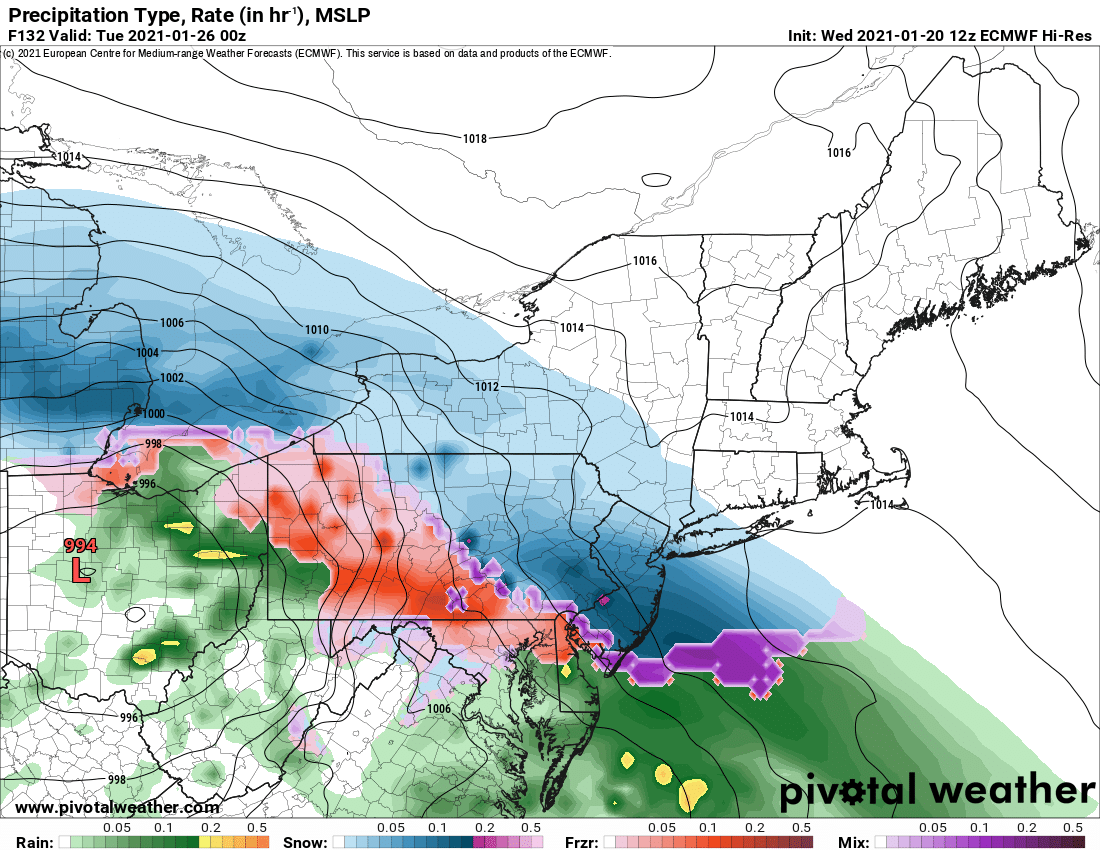
The latest ECMWF suggests a storm system will form in the Great Lakes and Mid Atlantic regions on Monday into Tuesday. It intensifies the storm just enough, while bringing just enough cold air into it, to create measurable snowfall in parts of New York, Pennsylvania, New Jersey, and points north and east from there. On its latest forecast track, it suggests some of the snow could change to sleet, freezing rain, or plain rain on the southern side of the storm.
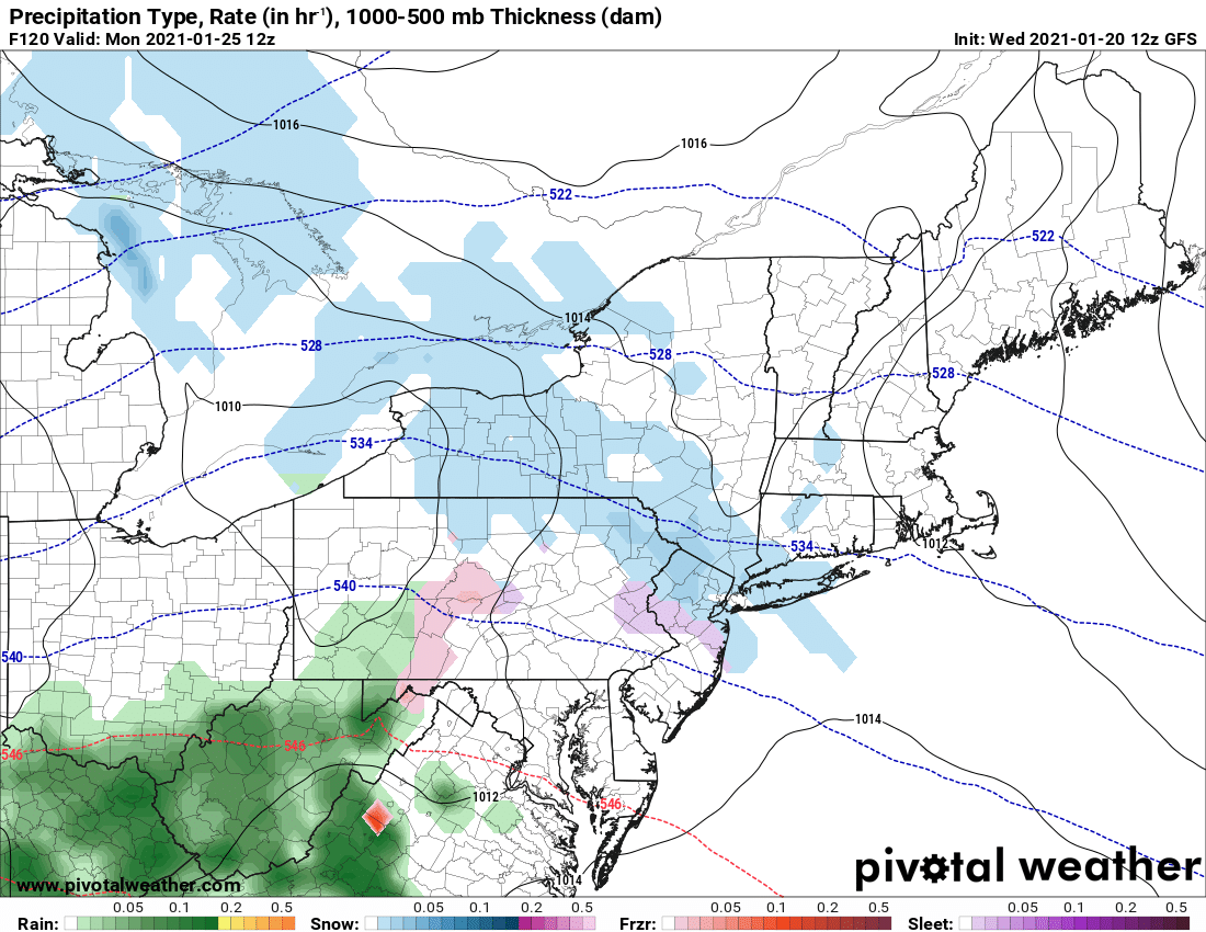
The latest GFS suggests a disturbance with the same roots will develop, but won’t develop nearly as robust as the ECMWF suggests. Because the system lacks development, the GFS has it moving along at a quicker clip than its European counterpart, bringing light precipitation through the northeast a full day beforehand. Because the system is moving quickly, doesn’t have time to develop, and doesn’t have time to bring in much in the way of moisture or precipitation with it, the GFS forecasts more non-accumulating passing snow showers than any widespread significant accumulating snow.
While the European forecast model has been showing a similar storm evolution on recent forecast runs, the American forecast model has been equally consistent showing a non-storm. Due to that conflict, meteorologists have low confidence that either scenario will be right.
The National Weather Service office in Mount Holly, New Jersey, is tracking the potential storm. This particular office is responsible for official forecasts and winter weather watches and warnings for the area that could be impacted should a storm form: Delaware, northeastern Maryland, much of New Jersey, and eastern Pennsylvania. In their latest forecast discussion, they share, “We’ll still have to watch for the potential system early next week for Monday into Tuesday. However in the big picture, there will be a strong blocking high far to our north near Baffin Island while an upper level low continues to sit and spin over Atlantic Canada. With these features as such the -AO / -NAO pattern will be continuing and this is important to note as it’s this pattern that’s helped to suppress to our south several potential storms over the past couple weeks that the models first hinted at in the longer range.” They add, “It needs to be stressed that forecast confidence for this time period is still low and given how similar systems have played out recently we keep (probabilities of precipitation) at only chance. ”

The -AO / -NAO pattern the National Weather Service references deals with the weather pattern over the higher latitudes. The Arctic Oscillation (AO) is a climate index of the state of the atmospheric circulation over the Arctic. It consists of a positive phase (+), featuring below average geopotential heights , which are also referred to as negative geopotential height anomalies , and a negative phase (-) in which the opposite is true. In the negative phase, the polar low pressure system, also known as the polar vortex, over the Arctic is weaker, which results in weaker upper level winds. The result of the weaker westerlies is that cold, Arctic air is able to push farther south into the U.S., while the storm track also remains farther south. The opposite is true when the AO is positive: the polar circulation is stronger which forces cold air and storms to remain farther north. The Arctic Oscillation often shares its phase with the North Atlantic Oscillation (NAO) and its phases directly correlate with the phases of the NAO concerning implications on weather across the U.S.. The NAO consists of two pressure centers in the North Atlantic: one is an area of low pressure typically located near Iceland, and the other an area of high pressure over the Azores. Fluctuations in the strength of these features significantly alters the alignment of the jet stream, especially over the eastern U.S., and ultimately affects temperature and precipitation patterns in this area.
Snow lovers would ideally want to see a + AO / + NAO pattern develop while those anxious to get through winter fast would want to see the opposite. While winter storms can develop in either pattern, they are favored in one over the other.
There are some indications the pattern could be evolving from a positive to negative phase, but it is too soon to tell if that will indeed happen, and if so, when it would happen.
