Some snow is expected to fall this weekend, ending a prolonged snow drought for some in portions of Pennsylvania, New Jersey, and New York. However, the heaviest snow is expected to be confined to areas north and west of I-95, with mainly rain likely along and to the south and east of the major northeast highway from New York City south. And while some areas will pick up several inches of snow this weekend, it’s likely to be washed away as a stronger, more substantial storm brings wind-whipped heavy rains to the northeast next week.
High pressure will depart offshore as a weekend system arrives in the northeast during the day on Saturday. A shortwave trough along the subtropical jet will eject out of the Gulf Coast region and lift across the Mid Atlantic; an associated area of low pressure will strengthen as it moves through the southeast and up the Mid-Atlantic coast Saturday and into Sunday.
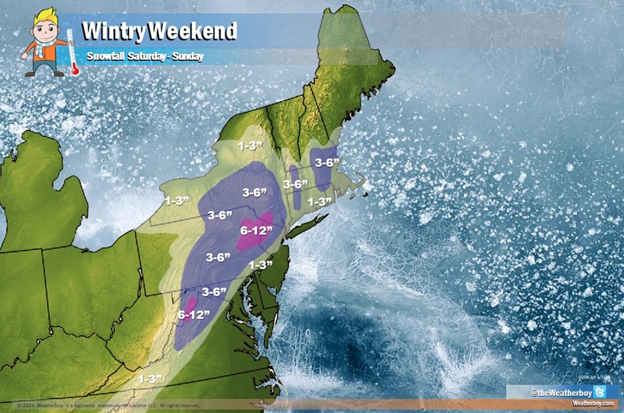
The exact track of this surface low will determine what specific impacts there will be. Latest model guidance suggests a weaker system that moves more offshore, which would result for a winter storm with limited impacts. At this time, it appears the highest elevations along the I-78 corridor in northern New Jersey and northeastern Pennsylvania will have the best chance for the most snow while little to no snow will fall near and to the south of the I-95 corridor south of New York City.
For now, it looks like 1-3″ of snow is possible near and just north of I-95 from New York City and places south into western Virginia, with 1-3″ also possible over much of southeastern New England. Heavier 3-6″ snows are expected more north and west over northern New Jersey, eastern and central Pennsylvania, Upstate New York, and portions of central New England and central West Virginia. There’s also a risk of 6-8″ snows, and localized heavier amounts, over portions of northwestern New Jersey, northeastern Pennsylvania, and southern Upstate New York. Exactly how much more snow beyond 6″ falls will be dependent on the storm track and the amount of cold air that could be tapped by this system.
The shortwave trough responsible for this system is expected to be better sampled by upper air observations over the next 24 hours which will help refine the forecast ahead of its expected impacts Saturday into Sunday.
Beyond the threat of significant accumulating snow north and west of I-95, the system will also bring heavy rain, gusty winds, and the threat of coastal flooding though with strong onshore flow.
Quiet weather is forecast to return Sunday night into Monday as high pressure returns across the region, but that break will be short-lived. Another more impressive and well forecast system will approach the northeast Tuesday, bringing widespread heavy rainfall and flooding threats along with strong onshore winds and coastal flooding again. This next system is likely to be milder than the weekend system, which will help transport heavy rain over areas that see accumulating snow this weekend. With that snowmelt, there could be additional flooding problems, especially over southern New York, northern New Jersey, and northeastern Pennsylvania.
