A significant storm surge is likely for portions of the U.S. east coast, prompting the National Hurricane Center to issue Storm Surge Warnings and Watches. Beyond the warning zone, a storm surge is likely as far south as South Carolina to as far north as New Jersey as Ophelia makes landfall in the Mid Atlantic.
Right now, a Storm Surge Warning is in effect from Beaufort Inlet, North Carolina to Chincoteague, Virginia, for the area in Chesapeake Bay south of Colonial Beach, Virginia, theNeuse and Pamlico Rivers, and portions of Pamlico and Albemarle Sounds. A Storm Surge Warning means there is a danger of life-threatening inundation, from rising water moving inland from the coastline, during the next 36 hours in the indicated locations.
“This is a life-threatening situation,” the National Hurricane Center warns. “Persons located within these areas should take all necessary actions to protect life and property from rising water and the potential for other dangerous conditions. Promptly follow evacuation and other instructions from local officials.”
A Storm Surge Watch is in effect for the area extending from Surf City, North Carolina to Beaufort Inlet, North Carolina as well as the remainder of Pamlico and Albemarle Sounds. A Storm Surge Watch means there is a possibility of life-threatening inundation, from rising water moving inland from the coastline, in the indicated locations during the next 48 hours.
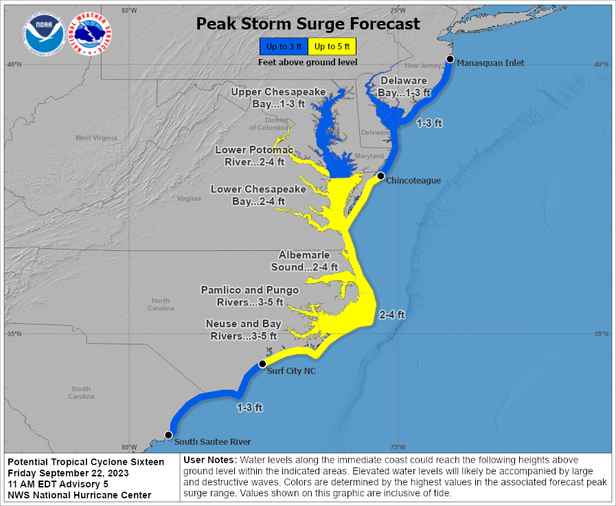
If the storm surge arrives at times of high-tide, the National Hurricane Center expects this level of inundation over dry ground in these areas:
Neuse and Bay Rivers: 3-5 feet
Pamlico and Pungo Rivers: 3-5 feet
Chesapeake Bay south of Colonial Beach: 2-4 feet
Surf City, North Carolina to Chincoteague, Virginia: 2-4 feet
Albemarle Sound: 2-4 feet
South Santee River, South Carolina to Surf City, North Carolina: 1-3 feet
Chincoteague, Virginia to Manasquan Inlet, New Jersey: 1-3 feet
Upper Chesapeake Bay: 1-3 feet
Delaware Bay: 1-3 feet
The combination of a dangerous storm surge and the tide will cause normally dry areas near the coast to be flooded by rising waters moving inland from the shoreline.
