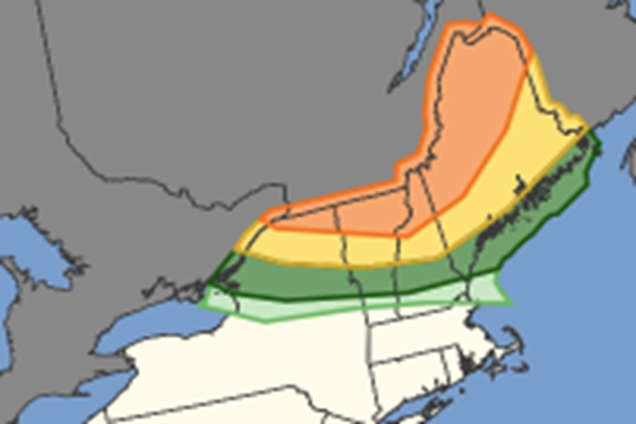
The National Weather Service’s Storm Prediction Center (SPC) is warning of the threat of severe thunderstorms for portions of northern New England on Tuesday with an elevated risk of tornadoes across northern New York, Vermont, New Hampshire, and Maine. According to the SPC, more than 1.8 million people are at risk of tornadic thunderstorms including those in the cities of Burlington, Vermont, and Lewiston, Bangor, Brunswick, and Auburn in Maine.
The National Weather Service says this is a very unusual and rare tornado threat for northern New England. The combined states of Vermont, New Hampshire, and Maine average only about four tornadoes per year. According to historical NOAA data, most of these storms are classified as weak (EF-0 or EF-1), making the region one of the least tornado-prone areas east of the Rocky Mountains.
Upper-level ridging will continue across much of the continental US on Tuesday while a strong upper trough moves into New England during the evening/overnight along with a surface cold front. Strong northwesterly flow aloft will be present at the start of the day, with computer forecast models suggesting that a subtle perturbation may be moving through the region early in the day too. The SPC says that some convection may be associated with this feature, though the expectation is that this activity will be weakening with time. Any cloud cover from this activity would delay surface heating in some areas. Nevertheless, heating and moistening of the atmosphere ahead of the cold front appears more than sufficient for severe storm development by late afternoon into the evening.
Initial development will likely occur in southern Quebec along the front and move into New England. The strongest forcing for ascent within the region will be during the late afternoon with abundant atmospheric instability persisting into early evening across parts of New England.
“Supercell structures will be favored, though bowing structures may also develop due to storm interactions or locally greater linear forcing,” warns the SPC, adding that “Large hail, including potential for 2″+ with supercells, is possible.”
Severe and damaging winds are also expected. Bowing segments that develop will have potential for significant wind gusts at or greater than hurricane force wind speeds.
“Low-level hodographs will also support a threat for a few tornadoes,” cautions the SPC. “A strong tornado is possible, but will be conditional on a discrete supercell persisting into the early evening.”
