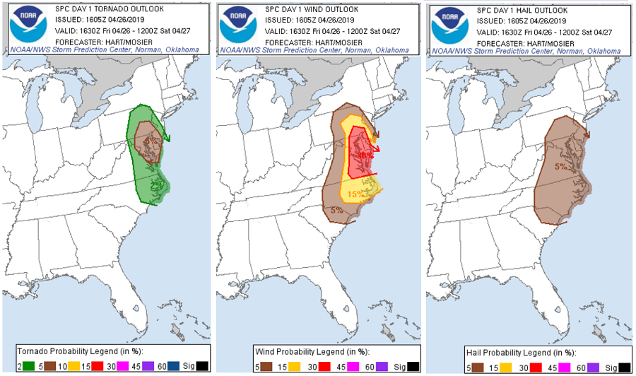
Tornadoes and wind damage will be possible in the Mid Atlantic today, with the greatest risk of violent weather over southern New Jersey, southeastern Pennsylvania, Delaware, eastern Virginia, Washington, DC, and northeastern Maryland. According to the National Weather Service’s Storm Prediction Center, damaging wind should be the most common event, though a few tornadoes also are
possible.
At the moment, water vapor imagery shows a strong upper trough approaching the Mid Atlantic region, with large mid-level height falls forecast across the region this afternoon. Visible satellite imagery shows broken cloud cover throughout the area, allowing daytime heating and destabilization to occur. This should result in widespread thunderstorm activity later today, with the potential for damaging winds and a few tornadoes. The primary severe threat appears to be associated with a line of convection currently over eastern West Virginia and western Pennsylvania. This activity will intensify by mid-afternoon as it tracks into the warmer and more unstable air across central Virginia and central Pennsylvania. Strong westerly flow aloft and considerable low-level shear will promote bowing segments in the line capable of damaging wind gusts, with a few tornadoes also possible along the line. Other storms are expected to form ahead of the line in a weakly capped environment, also posing a risk of damaging winds and perhaps tornadoes. Due to the increased threat of violent weather, the Storm Prediction Center has upgraded an area within its Convective Outlook to an “enhanced” threat zone. This means numerous severe thunderstorms are possible, with severe weather more persistent or more widespread, with some isolated, intense cells.
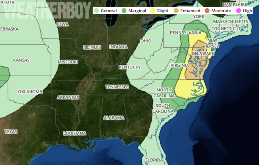
Due to the atmosphere ripe for severe storms, the National Weather Service says there’s an 80% chance that Severe Thunderstorm and/or Tornado Watches will be issued for portions of New Jersey, Pennsylvania, Delaware, Virginia, and Maryland this afternoon and evening. Should an actual severe storm or tornado materialize, the National Weather Service will issue a warning county-by-county as the storm marches through.
When a Tornado Warning is issued, people will only have moments to rush to a place of safety. Follow these tips:
- If you can safely get to a sturdy building, then do so immediately.
- Go to a safe room, basement, or storm cellar.
- If you are in a building with no basement, then get to a small interior room on the lowest level.
- Stay away from windows, doors, and outside walls.
- Do not get under an overpass or bridge. You’re safer in a low, flat location.
- Watch out for flying debris that can cause injury or death.
- Use your arms to protect your head and neck. Wear a helmet, like a bicycle helmet, for added protection.
