For most of January, there’s been global computer modeled forecasts hinting at the prospect of a major winter snow storm with blizzard conditions somewhere along the U.S. East Coast; while snowstorms have come to fruition in some form along portions of the northeast, none have become all-out widespread blizzards. And while the I-95 corridor has seen accumulating snow in recent weeks, bands of 6″+ of snow haven’t extended very far along the I-95 corridor. But is that all about to change? Today, two major global computer forecast models each suggest that an area of low pressure will “bomb-out” off the northeast coast over the upcoming weekend, setting the stage for blizzard conditions for at least portions of the northeast. Big questions remain with the forecast, including: will the modeled bomb really explode across the Northeast, or will the forecast models bomb-out and bust again?
While many people think a blizzard is simply a big snowstorm, they’re wrong. A blizzard is all about wind and visibility. According to the National Weather Service, three criteria must be reached before a storm is considered a blizzard. First, there needs to be sustained winds of 35 mph or frequent gusts over 35 mph. Second, due to the weather, the visibility must be reduced to 1/4 mile or less. This reduction can happen from falling heavy snow …or it could simply be previously fallen snow blowing about in the wind. You do not need fresh snow to be falling to reach blizzard criteria. Third, to count as a blizzard, the reduction in visibility and the strong winds must last for at least three hours. When all three of these conditions are met, you have more than a snowstorm: you have a full-fledged blizzard!
A “bomb cyclone” refers to the meteorological process of explosive cyclogenesis. Similar to a rapidly intensifying hurricane in the tropics in hurricane season, a bomb cyclone refers to a storm and a process in which atmospheric pressure drops quickly, the storm intensifies, with wind and precipitation increasing. In general, a bomb cyclone is a storm system that experiences a drop of at least 24 millibars (mb) within a 24 hour period.

Currently, the GFS and ECMWF global forecast models do suggest a bombing cyclone with blizzard conditions over portions of the northeast this weekend. The GFS and ECMWF are among many computer models meteorologists use to assist in weather forecasting. While meteorologists have many tools at their disposal to create weather forecasts, two primary global forecast models they do use are the ECMWF from Europe and the GFS from the United States. While the models share a lot of the same initial data, they differ with how they digest that data and compute possible outcomes. One is better than the other in some scenarios, while the opposite is true in others. No model is “right” all the time. Beyond the ECMWF and GFS models, there are numerous other models from other countries, other academic institutions, and private industry that are also considered when making a forecast.
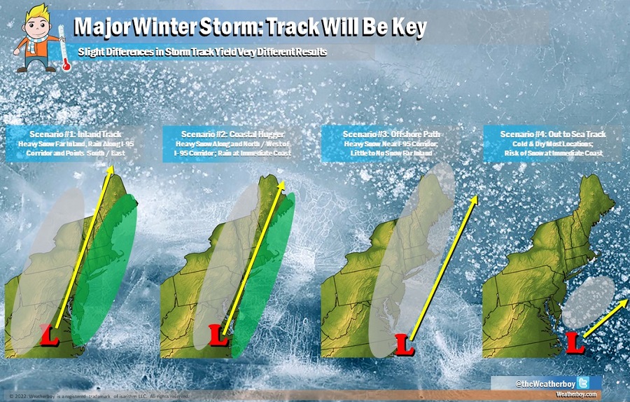
The storm track always helps define who will get precipitation and what kind of precipitation they’ll get. In the first scenario, a storm moves up the northeast well inland; this brings heavy rain well inland and keeps snow even farther inland. The second scenario follows a track up the I-95 corridor, bringing heavy snow far inland, heavy rain at the coast, and an icy mix of snow changing to rain in the middle. In the third scenario, the storm is far enough off-shore to keep precipitation as all snow in the northeast. But because the storm is off shore just far enough, not much in the way of snow falls far inland. In the fourth scenario, the storm moves so far out to sea that little snow is seen anywhere on land, although the immediate coast could see clouds and snowflakes.

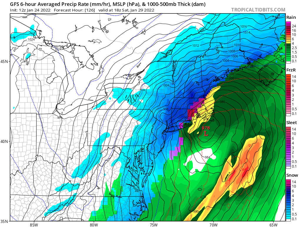
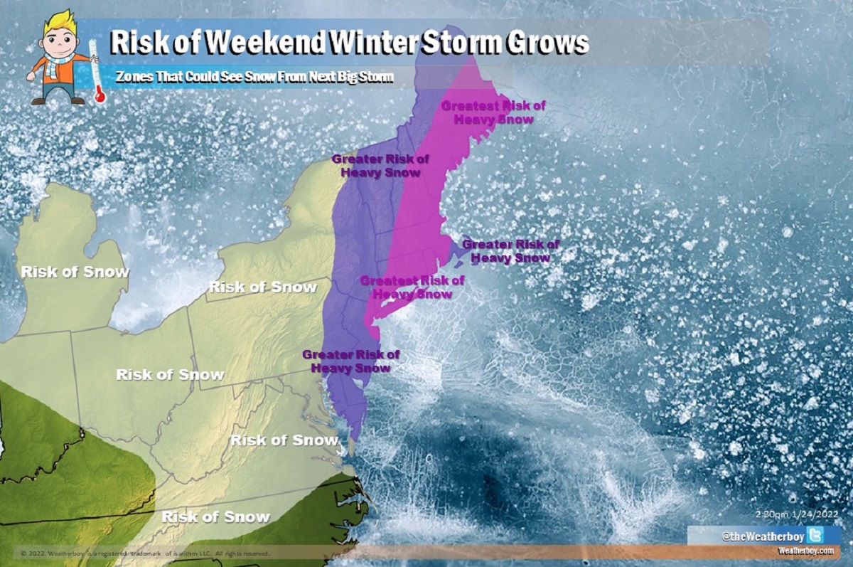
Today, the GFS and ECMWF both suggest a storm will follow scenario #3 and bring heavy snow up the coast. Because the center of the low is forecast to be east of Long Island, New Jersey, Delaware, and Maryland, snow wouldn’t extend too far to the west. However, snow that falls near the storm track would be heavy at times. If the center of the storm moves over southeastern New England, as the current GFS and ECMWF models suggest, snow could mix with or change to rain or an icy mix of freezing rain and sleet, over portions of southeastern New England. If that wintry mix or rain materializes, snow totals would be lower over far southeastern New England than elsewhere along the I-95 corridor from New York to Boston.
This afternoon’s run of the GFS shows an area of low pressure taking shape off the southeast coast late Friday. Late Friday night, the GFS suggests a surface low with a pressure of 1007 mb forms off-shore near the South/North Carolina border. From there, it “bombs” the storm down to a 985 mb low, putting it east of the Delaware/Maryland border by Saturday morning. With such a position, heavy snow would break out in northeastern North Carolina, eastern Virginia and Maryland, Delaware, New Jersey, and Connecticut, eastern Pennsylvania and New York, and eastern New England. By Saturday night, it has the low centered near Cape Cod as an even deeper 975 mb low. With the deep low pressure reading in the storm center and high pressure readings to the north and west from a High in southeastern Canada, the difference in pressure could lead to an area of high winds. These high winds could bring about blizzard conditions to portions of the northeast from Maine to New Jersey. The GFS model pushes the storm system into the Canadian Maritimes by Sunday afternoon, with fair and dry conditions returning to the northeast.
This afternoon’s run of the ECMWF is quite similar to the GFS. Late Friday night, it has an area of low pressure, at 1006 mb, developing well east of the South Carolina / Georgia border. It moves this system north up and in parallel to the coast, producing a 994 mb low east of the North Carolina / Virginia border by early Saturday morning. From there, it heads a bit more east than the GFS, with an even more powerful 958 mb low pressure area positioned south and east of the Cape Cod coast by Saturday afternoon. With the storm system modeled to be a bit more east than the GFS, it has more snow than a wintry mix/rain over southeastern New England which would increase snow totals there. But because it’s more east, the western extent of the snow will shift east too, with heavy snow not extended too much west than the New Jersey / Pennsylvania border and easternmost Upstate New York. As with the GFS, the ECMWF brings the low pressure system into the Canadian Maritimes by Sunday afternoon, allowing for fair and dry weather to return to the northeast.
Snow totals will be dependent on the final storm track and intensity. While it won’t be possible for meteorologists to accurately predict how much snow will fall for a few more days, the global forecast models are suggesting robust amounts. The ECMWF suggests 6″ or more of snow across New Jersey and points north and east, with amounts greater than a foot possible over central New Jersey, the New York City metropolitan area, Long Island, and southeastern New England. The ECMWF even suggests that more than 2 feet of snow is possible from this storm. Because the GFS brings the storm over southeastern New England, it cuts snow totals down to just a few inches over Cape Cod, Nantucket, Martha’s Vineyard, and Block Island. But like the ECMWF, the GFS paints a snowy picture with amounts of 12″ or more over portions of coastal central New Jersey, the New York City metropolitan area and western Long Island, and most of New Hampshire, Maine, Vermont, and Connecticut, northern Rhode Island, and the western 2/3rds of Massachusetts.

While the GFS and ECMWF are relatively aligned with how this snowstorm could unfold this weekend, that hasn’t been the case in recent days. Each model has suggested a more off-shore track which would limit accumulations in the northeast. While they’ve been on and off with the idea of a snowstorm for many days, today is the first time they’ve been somewhat aligned with a similar path. Until more of those model outputs are just as aligned, confidence in the storm track and forecast amounts will remain moderate at best. After more model runs and after more data is digested to help meteorologists understand just exactly how this storm will take shape and where, more higher-confidence forecasts will likely come out from Wednesday afternoon and beyond.
While it still too early to determine whether or not a blizzard will unfold this weekend, it is never too early to prepare for a winter storm. The best time to prepare for it is well before any threat actually arrives.
Winter storms can immobilize a region and paralyze a city, stranding commuters, closing airports, disrupting the flow of supplies, and impacting emergency first responders. Heavy wet snow can cause roofs to collapse and force trees and large limbs to tumble down on nearby structures and power lines. Homes may be isolated for days with electricity and other utility lines cut. The cost of snow removal, repairing damages, and the loss of business can have severe economic impacts on cities and towns.
Beyond heavy snow, winter storms can also bring other weather related dangers. Nor’easters can bring heavy wind, high surf, coastal flooding, and significant beach erosion. Some well know Nor’easters include the notorious Blizzard of 1888, the “Ash Wednesday” storm of March 1962, the New England Blizzard of February 1978, the March 1993 “Superstorm” and the recent Boston snowstorms of January and February 2015. Past Nor’easters have been responsible for billions of dollars in damage, severe economic, transportation and human disruption, and in some cases, disastrous coastal flooding. Damage from the worst storms can exceed a billion dollars.
You don’t need to have blizzard conditions to have dangerous snow storm conditions. Blowing snow is wind-driven snow that reduces visibility. Blowing snow may be falling snow or it could be snow on the ground that is picked up by the wind. Snow flurries are typically defined as light snow falling for short duration with little to no accumulation while snow showers are known for snowfall at varying intensity for brief periods of time with light accumulations. Snow squalls, however, are severe, brief, intense snow showers accompanied by strong, gusty winds, and while short-lived, snow squalls can produce quick and significant accumulations. In and after snow storms, snow squalls can threaten a region with additional hazards.
When thunder roars, head indoors; lightning can kill in any season. While thunderstorms are typically associated with warmer weather, thunderstorms do pop up in intense winter storms. Lightning in a snow thunderstorm is just as dangerous as lightning in its warmer-weather sibling. The acoustics of fresh snow cover and a landscape typically free of leaves can also help make thunder sound more dramatic than it does at other times of the year. While some may be mesmerized by the sounds and scenes of thunderstorms inside snowstorms, people must remember that a thunderstorm at any time of year in any kind of weather is dangerous.
The National Weather Service is responsible for issuing weather related Warnings, Watches and Advisories for your local area. Issued by county, these advisories are based on local criteria. For example, the amount of snow that triggers a “Winter Storm Warning” in Atlanta, Georgia is much less than the snowfall required to trigger the identical warning in New York City. An Advisory generally means “be aware”; a Watch means “be prepared”; a Warning means “take action.” When a Warning, Watch, or Advisory is issued for your area, the National Weather Service will define the specific threat and will provide you with a time frame for that threat.
When a winter storm is forecast to impact your area, be sure to prepare yourself, your home, and your car. Be sure to check-in on friends, family, and neighbors –especially the elderly and others that may not be aware of the impending winter storm forecast.
Yourself
- – Stay indoors during the storm. Don’t venture out, especially if local officials tell you to remain at home. However, if you’re in a coastal flood threat zone and officials tell you to evacuate, evacuate! Get out as quickly and as safely as possible and get to your designated safe area.
- – When you do venture out after the storm, walk carefully on snowy, icy walkways.
- – Avoid over-exertion when shoveling snow. Heart attacks from snow shoveling are a major cause of death in the winter. If you must shovel, stretch before going outside. Make sure you’re well hydrated and take frequent breaks.
- – Stay dry. Wet clothing will loose all of its insulating value, allowing cold temperatures to permeate to your skin efficiently.
- – Watch for signs of frostbite: loss of feeling and an unusually pale appearance in your extremities. If this occurs, seek medical help immediately. Frostbite is a medical emergency! Call 911 for help if you can’t seek medical care yourself.
- – Watch for signs of hypothermia: uncontrollable shivering, disorientation, memory loss, slurred speech, drowsiness, and exhaustion. If these symptoms appear, get to a warm location as soon as possible. Remove any wet clothing and warm the center of the body first; drink warm, non-alcoholic beverage, and seek medical attention as soon as possible.
Your Home
- – Make sure your gutters are clean of debris.
- – Drain all outside hoses; shut off outside water valves where possible.
- – Make sure your home is well insulated; caulk and weather-strip doors and windows to keep cold air out and warm air in.
- – Repair roof leaks and remove tree branches that could get weighed down with ice or snow and fall on your or neighboring homes.
- – Wrap water pipes in your basement or crawl spaces with insulation sleeves to slow heat transfer.
- – Consider an insulated blanket for your hot water heater to keep water warmer longer should utilities fail.
- – If you have a fireplace, keep the flue closed when you’re not using it.
- – Have a contractor check your roof to see if it would sustain the weight of a heavy snowfall.
- – Make sure your furniture isn’t blocking your home’s heating vents.
Your Car
- – Drive only if it is absolutely necessary. If you must drive, travel during the daylight hours.
- – Don’t travel alone. Keep others informed of your schedule.
- – Stay on main roads and avoid back road shortcuts.
- – Top off antifreeze, windshield wiper fluid, gas, oil and other fluids. Have spare fluids in your car should you run out.
- – Make sure your tires have enough tread. Consider snow tires or chains.
- – Keep bagged salt or sand in the trunk for extra traction and to melt ice.
- – Clear snow from the top of the car, headlights and windows. Never drive with snow on your car.
- – Save the numbers for your insurance agent and towing service into your cell phone. Keep a back-up on paper in your car.
- – Keep a cold-weather kit in your trunk. It should include a blanket or sleeping bag, gloves, hard candy, bottled water, folding shovel, first aid kit, flashlight and cell phone charger.
- – If you become trapped in a vehicle during a winter storm, remain inside and remain calm. Rescuers are more likely to find you there. Run the engine and heater about 10 minutes every hour; be sure to clear snow from your exhaust pipe to reduce your risk of carbon monoxide poisoning. Move around to maintain heat; use maps, floor mats, and seat covers for insulation. Drink non-alcoholic fluids to avoid dehydration. Turn on the inside light at night so rescue crews can find you. If you’re stranded in a remote area, stomp-out “HELP” or “SOS” in the snow once it’s done falling so rescue crews from the sky have a better chance of locating you.