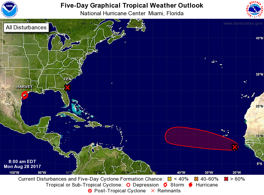
Harvey, Irma, and Jose could be triple tropical threats facing the country in the coming days. Harvey, an existing threat, may be followed-up with Irma on the US East Coast as Potential Tropical Cyclone #10 develops. Meanwhile, the National Hurricane Center (NHC) believes there’s a high chance that a system over the far Atlantic will develop over time too.
Harvey, which continues to dump epic rains leading to historic floods in Texas, will continue to spin about over Texas for a few days. While the wet pattern will remain in place over Texas for a considerable amount of time, it looks like Harvey will finally depart the Lone Star State later this week. The National Hurricane Center forecasts that the center of Harvey’s circulation will exit Texas into northwestern Louisiana on Thursday morning.
Potential Tropical Cyclone #10 continues to spin about east of the Georgia coast. The National Hurricane Center believes there’s a 90% chance that it will form into a tropical depression or storm today; when this system becomes a named tropical cyclone, it will be called Irma. Potential Tropical Cyclone Ten continues to lack a well-defined center. Moreover, the convection – while deep – is now strung out linearly from northeast to southwest, more reminiscent of a front or trough. Thus it does not appear that genesis into a tropical cyclone is imminent. While the disturbance has plenty of warm water and moist air available, it’s being sheared by strong upper-level westerlies. The shear may lessen slightly over the next day or so, allowing a short window of opportunity for the system to undergo genesis and some intensification. But in about 36-48 hours, the shear should go back up as the system reaches cooler waters, likely limiting the intensification as a tropical cyclone. At about the same time, the system should transform into an extratropical cyclone and further develop via baroclinic forcing away from the US coastline.
The National Hurricane Center points out that even though potential impacts from this system’s winds could occur within the 36 hour time frame for a Tropical Storm Warning, because the intensity forecast is for a low-end tropical storm and the winds are all over the eastern semicircle, the threat of coastal tropical storm winds remains possible but low. As such, the Tropical Storm Watch for portions of South Carolina and North Carolina are retained at this time. Currently, the Tropical Storm Watch is posted from South Santee River to Duck and includes the Albemarle Sound and the Pamlico Sound.
A more impressive threat could be growing over the Atlantic in an area prime for development this time of year. The National Hurricane Center believes there’s a high chance (70%) that this system will become a tropical cyclone in the next five days. A tropical wave and associated low pressure area located just offshore of the coast of western Africa is producing a large area of showers and thunderstorms. This system has become better organized since yesterday, and a tropical depression could form in a few days over the eastern Atlantic. The low is forecast to move westward at 15 to 20 mph over the tropical Atlantic during the next several days. Regardless of development, heavy rain is possible in portions of the Cabo Verde Islands through Wednesday. Over time, global forecast models are very bullish with this system, with many forecast runs suggesting that this disturbance will become a hurricane over time. When this tropical cyclone forms and is named, it would be called Jose after Irma. If Potential Tropical Cyclone #10 fails to become a named system, Irma would be used for it.
Experts believe this Atlantic Hurricane Season, which runs through to the end of November, will be a busy one. Dr. Phil Klotzbach and the experts at Colorado State University updated their seasonal outlook again on July 5, showing a much more active than normal season expected. The National Oceanic and Atmospheric Administration (NOAA) also released their own forecast which shows this hurricane season to be likely more active than others.