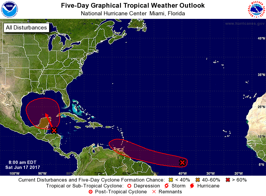
The National Hurricane Center (NHC) is closely monitoring two storm systems for likely tropical cyclone development. According to the NHC, each has a 70% chance of developing into a tropical cyclone over the next five days. One of those two storms may impact the United States as early as next week.
A broad trough of low pressure is producing a large area of cloudiness and showers over the northwestern Caribbean Sea and the nearby land areas. The NHC says conditions appear to be favorable for gradual development of this large disturbance while it moves slowly northwestward across the Yucatan Peninsula this weekend, and a tropical cyclone could form early next week over the southern or central Gulf of Mexico. Regardless of development, heavy rains are likely to spread over portions of Central America, the Yucatan Peninsula, Jamaica, the Cayman Islands, and western Cuba during the next several days. While there’s only about a 20% chance of tropical cyclone development over the next 48 hours, chances are high -at 70%- that this will become a tropical cyclone …and it is likely that this system will become Bret, the next named storm of the 2017 Atlantic Hurricane Season.
There is poor computer forecast model agreement on where this system will move over time; most of these forecast models struggle with storm movement and intensity prior to storm formation. Because there is a threat of a landfalling tropical cyclone along the US Gulf Coast as early as this coming week, residents there should make sure their Hurricane Action Plans are in order. Over time, it may become necessary to act on them. The East Coast should also monitor it; it’s possible any system in the Gulf could cross the southeastern US and move up the US east coast.
Another tropical disturbance is located in the far Atlantic Ocean. It is unusual for a system to form this time of year so far away, although not completely unheard of. A tropical wave located about 1500 miles east-southeast of the southern Windward Islands is producing scattered showers and thunderstorms. This disturbance has changed little in organization since yesterday. However, some development is expected during the next few days before conditions become less favorable for tropical cyclone formation. This system is expected to continue moving toward the west or west-northwest at 15 to 20 mph over the tropical Atlantic during the next several days. This system has a better chance of developing into a tropical cyclone in the next 48 hours over the other; the NHC has those odds pegged at 40%. There’s also a high chance, 70%, that this will become a tropical cyclone over the next 5 days. If this system becomes a named storm after Bret, it would be called Cindy.
Tropical forecast experts believe this will be a an active season. Dr. Phil Klotzbach and the experts at Colorado State University recently updated their seasonal outlook to show more storms forming in the Atlantic basin this season. The National Oceanic and Atmospheric Administration (NOAA) also released their own forecast which shows this hurricane season to be likely more active than others.