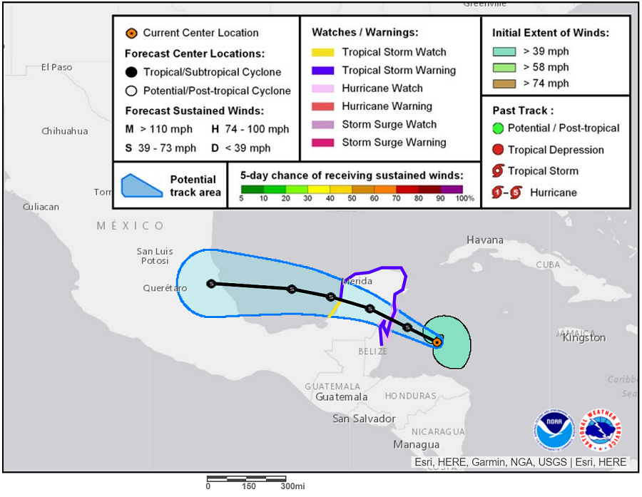
The latest advisory from the National Hurricane Center (NHC) shows that Tropical Storm Franklin is gaining strength. Visible and microwave satellite imagery shows that Franklin’s cloud pattern is becoming better organized with banding features starting to appear. Inner-core convection is not very abundant over the southwest quadrant and the center is still estimated to be located near the southwest edge of the main cloud mass.
An Air Force Hurricane Hunter aircraft is scheduled to investigate Franklin this afternoon and should provide a better estimate of the strength of the storm. The upper-level environment is becoming increasingly conducive for intensification, with anticyclonic outflow becoming established over the tropical cyclone during the next couple of days. Franklin could become a hurricane before its first landfall, but interaction with the Yucatan Peninsula will cause some weakening on Tuesday. Thereafter, Franklin will be moving over sea surface temperatures near 30 degreees C, which favors strengthening. According to the NHC, Franklin should be near or at hurricane intensity by the time it makes landfall in mainland Mexico.
The initial motion of Tropical Storm Franklin continues to be west-northwestward at about 12 kts. Little changes have been made to the track forecast from previous NHC advisories. The steering environment remains fairly simple, and is dominated by a zonally-oriented ridge that should cause a west-northwestward to westward motion for the next several days.
With the storm approaching land, a variety of advisories have been issued. A Hurricane Watch is in effect for the coast of Mexico from Chetumal to Punta Allen. A Hurricane Watch means that hurricane conditions are possible within the watch area within the next 24 hours. A Tropical Storm Warning is in effect for Belize City north to the border of Mexico and the coast of Mexico from Chetumal to Campeche. A Tropical Storm Warning means that tropical storm conditions are expected somewhere within the warning area within 24 hours. A Tropical Storm Watch is also in effect for the coast of Mexico from Campeche to Sabancuy. A Tropical Storm Watch means that tropical storm conditions are possible there.
Experts believe this Atlantic Hurricane Season, which runs through to the end of November, will be a busy one. Dr. Phil Klotzbach and the experts at Colorado State University updated their seasonal outlook again on July 5, showing a much more active than normal season expected. The National Oceanic and Atmospheric Administration (NOAA) also released their own forecast which shows this hurricane season to be likely more active than others.