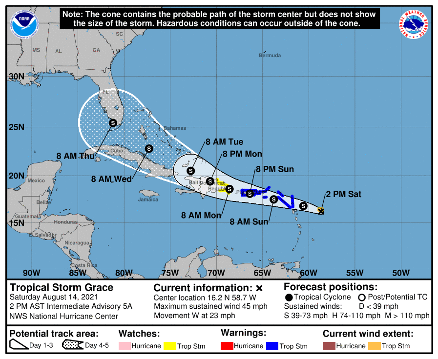
Tropical Storm Watches and Warnings are now in effect in the Caribbean as Tropical Storm Grace moves to the west-northwest. While NOAA Hurricane Hunter aircraft currently investigating the storm doesn’t find it well organized, they did find tropical storm force winds in the storm. Strong winds and heavy rains are expected to lash islands in the Caribbean over the next several days before a possible impact to Florida or the U.S. East Coast by later in the week.
In the last update from the National Hurricane Center (NHC), Grace was located about 185 miles east-southeast of the Leeward Islands. It is moving to the west at 23 mph; it has maximum sustained winds of 45 mph; minimum central pressure is 1007 mb or 29.77″.
With the storm approaching, a Tropical Storm Warning is in effect for Antigua and Barbuda, Anguilla, St. Kitts and Nevis, and Montserrat, Saba and Sint Eustatius, Sint Maarten, St. Martin and St. Barthelemy, both the British and U.S. Virgin Islands, and Puerto Rico, including Vieques and Culebra. A Tropical Storm Watch is in effect for the south coast of the Dominican Republic from Punta Caucedo to Cabo Engano, and the north coast of the Dominican Republic from Cabo Frances Viejo to Cabo Engano. A Tropical Storm Warning means that tropical storm conditions are expected somewhere within the warning area within 36 hours while a Tropical Storm Watch means that tropical storm conditions are possible within the watch area, generally within 48 hours.
The NHC says that interests elsewhere in the Dominican Republic, Haiti, the Turks and Caicos Islands, and the southeastern Bahamas should monitor the progress of Grace. Additional watches and warnings will likely be required for this area later today and tonight. It is becoming likely areas hit hard by today’s massive earthquakes in Haiti will see serious impacts from Grace in the coming days.
Tropical storm conditions are expected within the warning area in the Leeward Islands by tonight or early Sunday, and in the Virgin Islands and Puerto Rico beginning on Sunday. Tropical storm conditions are possible within the watch area in the Dominican Republic Sunday night into Monday.
Heavy rain is likely from this system. Over the northern Leeward Islands and Virgin Islands, 3-6″ of rain is forecast. This rainfall may produce scattered areas of flash and urban flooding. Over Puerto Rico and the Dominican Republic, 3-6″ of rain is expected there too with isolated amounts of up to 8″ possible. Heavy rainfall could lead to flash, urban, and small stream flooding as well as potential mudslides there.
