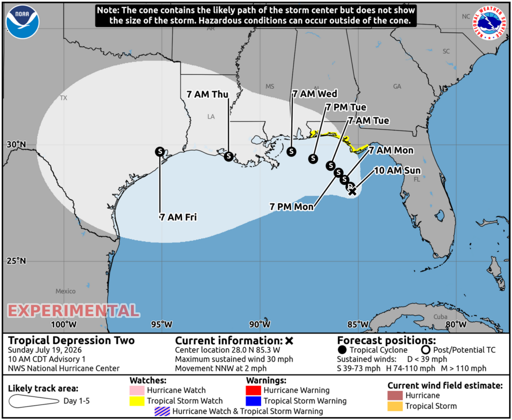
The National Hurricane Center (NHC) has started to issue Tropical Storm Watches across portions of the coast of the Gulf of America as Tropical Storm Bertha takes shape there. The area of low pressure that NHC has been monitoring in the northeastern Gulf of America during the past few days has now developed a well-defined low-level circulation. The NHC says that the convective activity remains patchy, likely due to intrusions of dry air from its northeast, but there is enough persistent convection near the center and in bands on its northeast and southwest sides to justify this system as a tropical depression.
The Air Force Hurricane Hunters are scheduled to investigate this system later today, and their data will be helpful to better assess the system’s initial structure.
“The initial motion of the system is difficult to know since it has only recently become well defined, but our best guess is north-northwestward at 3 kt,” the NHC said in their first advisory for the storm.
The storm, located near 28.0N 85.3W, which is roughly 155 miles south of Panama City, Florida, has maximum sustained winds of 30 mph and a minimum central pressure of 1011 mb or 29.86″. It is expected to strengthen to a tropical storm and be named Bertha soon.
As a result of the expected intensification, the National Hurricane Center has issued a Tropical Storm Watch for Florida from the Ochlockonee River to the Alabama border. A Tropical Storm Watch means that tropical storm conditions are possible within the watch area, in this case in the next 36 to 48 hours.
“Additional watches will likely be required over the next day or two,” cautions the NHC.
The depression is moving toward the north-northwest near 2 mph and a slow northwestward or north-northwestward motion is expected during the next day or two, followed by a turn toward the west. On the forecast track, the system will move near or along the northern Gulf coast during the next several days. The NHC says that gradual strengthening is forecast, and the depression is expected to become a tropical storm tonight or on Monday.
The system is currently caught in weak steering currents between a ridge over the western Atlantic, another ridge over the south-central and southwestern U.S., and a trough over the northeast U.S. This pattern should take the cyclone slowly northwestward through Monday night, and the system will likely be close enough to the Florida Panhandle to bring the potential for tropical storm conditions there. After that time, a turn to the west or west-northwest seems to be the most likely scenario as the ridge over the southern U.S. builds eastward, taking the system near or across the Gulf coast during the middle and latter portions of the week. By Friday morning, the NHC believes the storm will arrive near Houston, Texas.
“The sprawling nature of the system, nearby dry air, and some northeasterly vertical wind shear suggest that any strengthening should be slow to occur, especially in the short term,” says the National Hurricane Center. However, they add, “Nonetheless, the system is expected to become a tropical storm as it approaches the Florida Panhandle during the next day or two. There seems to be a better opportunity for the system to strengthen once it turns westward, however, the amount of strengthening will be dependent on how far offshore the circulation is”
For now, the NHC is passing along three key messages.
The first key message is that the depression is expected to gradually strengthen and could bring tropical storm conditions to portions of the Florida Panhandle, where a Tropical Storm Watch has been issued.
The second key message is that interests in Alabama, Mississippi, Louisiana, and Texas should monitor the progress of this system, as watches could be required for portions of that area over the next day or two.
The third key message is that areas of flash flooding will be possible through Thursday along the eastern and central Gulf Coast from western Florida to southern portions of Alabama, Mississippi, and Louisiana.
