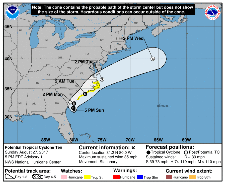
The National Hurricane Center has posted Tropical Storm Watches along portions of the east coast ahead of what will likely become Tropical Storm or Hurricane Irma in the coming days. For now, the system is officially known as “Potential Tropical Cyclone Ten.”
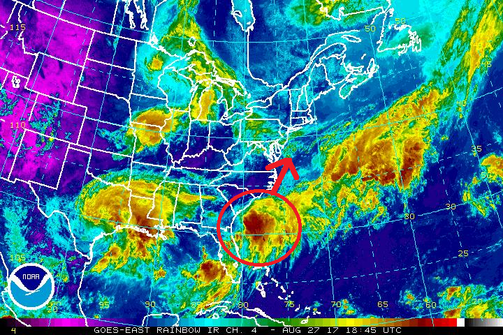
Convection associated with the broad area of low pressure located east of the Georgia coast has increased markedly today. Visible satellite imagery shows multiple low-level swirls rotating around a mean center, but ASCAT data earlier today showed that the circulation was not yet well-defined. The ASCAT data and buoy observations indicate that the initial intensity is 30 kt, and buoy data suggest the central pressure is around 1007 mb. While the system is expected to remain sheared, the National Hurricane Center (NHC) believes it has a high chance of becoming a tropical depression or tropical storm before it becomes baroclinic in about 48 hours. Some forecast guidance also suggests that this system may become a Category 1 hurricane; however, most guidance keeps this system no stronger than tropical storm strength.
Due to the potential for this system to bring tropical storm conditions to the coast from northern South Carolina through North Carolina, advisories are being initiated on this system as a Potential Tropical Cyclone. A Tropical Storm Watch is in effect from South Santee River, South
Carolina, to Duck, North Carolina. A Tropical Storm Watch means that tropical storm conditions are possible within the watch area, in this case within the next 24 to 48 hours.
The system is currently moving little in a region of weak steering, but should begin to move slowly northward and then quickly accelerate northeastward ahead of a mid-latitude trough moving into the mid-Atlantic states. The NHC forecast follows the trend of the
global models keeping the low center near the coast, but as usual there is more uncertainty than usual in the track forecast for a weak/developing system. After the system moves into the western Atlantic, it should continue accelerating east-northeastward ahead of the upper trough through the end of the period.
Despite the sheared envirionment, the system should be able to intensify a little via diabatic processes before it intensifies further as it undergoes a more substantial baroclinic intensification at 48 hours and beyond. The NHC intensity forecast follows the intensity consensus through 36 hours and then follows the trend of the global model guidance and guidance from the NOAA Ocean Prediction Center.
The National Hurricane Center also points out that north of Duck, North Carolina, hazards from this system will be handled with non-tropical products issued by local National Weather Service offices in Virginia and New Jersey.
Experts believe this Atlantic Hurricane Season, which runs through to the end of November, will be a busy one. Dr. Phil Klotzbach and the experts at Colorado State University updated their seasonal outlook again on July 5, showing a much more active than normal season expected. The National Oceanic and Atmospheric Administration (NOAA) also released their own forecast which shows this hurricane season to be likely more active than others.
