
While soaking rains persist on the windward portions of Hawaii as tropical moisture lingers in Lane’s wake, eyes are on two additional threats that’ll enter the Central Pacific Hurricane Basin in the coming weeks. The National Hurricane Center upgraded the latest tropical cyclone to Tropical Storm Meriam. The National Hurricane Center believes there’s a 90% chance that another tropical disturbance behind it will become a tropical cyclone soon. Once that system is named, it would will become Norman. While both of these storms will march towards Hawaii, one is more of a threat than the other.
Prior to those threats, Hawaii is still dealing with the aftermath of Hurricane Lane which brought epic rainfall amounts to Hawaii over the last several days. Significant flash flooding has occurred in multiple areas across the northeast and east facing slopes of the island, requiring several evacuations and water rescues.
Mountain View, HI measured 51.53″ of rain for the period from noon on August 22 to 4am on August 26. While this is a preliminary total subject to final quality control, this is the third highest storm total rainfall ever from a tropical cyclone in the United States since 1950. The highest total happened just a year ago with Hurricane Harvey in Texas; there, 60.58″ of rain fell in Nederland. The second highest total, and the highest tropical cyclone storm total rainfall in Hawaii is 52.00 inches, measured at Kanalohuluhulu Ranger Station, during Hurricane Hiki in 1950.
Current view from #RainbowFalls by Hilo, Hawaii where rain and flooding persists. #HIwx #Lane pic.twitter.com/XyKsvwznMf
— the Weatherboy (@theWeatherboy) August 26, 2018
Hilo Airport measured 36.76 inches of rain for the four day period running from 12 midnight August 22 through 11:59pm on August 25. This is the wettest four day period ever observed at Hilo, with records dating back to 1949. Hilo also measured 15.00 inches of rain on August 24, which was the fifth wettest calendar day on record.
While Lane as a depression now continues to weaken and move further away from the islands, lingering moisture remains over the Aloha State. Shower activity has been on the decline over the last 12 hours, and this general trend is expected to continue today. The Flash Flood Watch remains in effect for the Big Island to Oahu through this afternoon. While showers will certainly continue beyond this afternoon, mostly over windward locations in a trade wind flow, the threat for flooding rain is decreasing. However, with soaked soil and high streams and rivers, it won’t take much additional rain to trigger flash floods. People are reminded: turn around, don’t drown; never drive through flood waters.
Trade winds are forecast to increase a bit by Tuesday and Wednesday which will allow for a drying trend.
While Hawaii begins to dry out, eyes will return to the tropics. Tropical Storm Miriam and what will likely become Norman could be threats in Hawaii’s future. However, both storms are far away and are of no immediate threat to Hawaii this month.
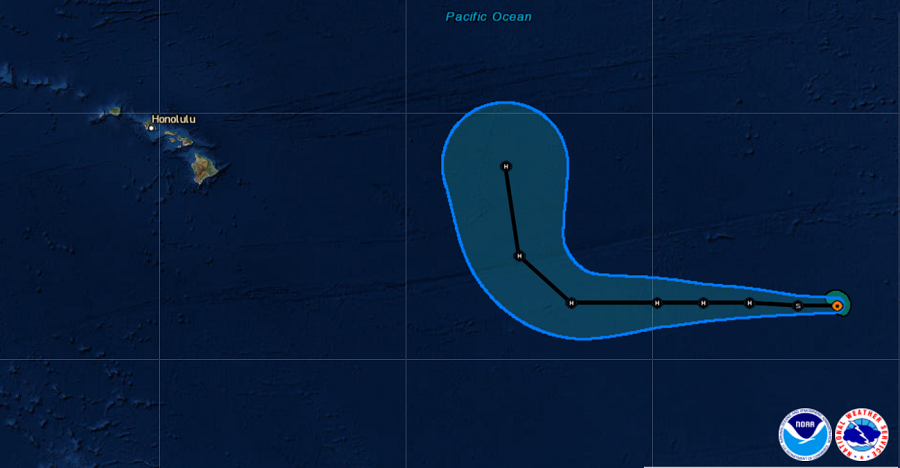
In the latest advisory from the National Hurricane Center, the center of Tropical Storm Miriam was located near latitude 13.6 North, longitude 126.6 West. Miriam is moving toward the west near 14 mph and this general motion is expected to continue during the next few days. Maximum sustained winds remain near 45 mph with higher gusts. Steady strengthening is forecast during the next couple of days, and Miriam is expected to become a hurricane by late Monday. Tropical-storm-force winds extend outward up to 45 miles from the center. The estimated minimum central pressure is 1004 mb or 29.65 inches. At this time, it appears a weakness in the Pacific will allow for eventual Hurricane Miriam to pass harmlessly to the north of Hawaii. However, a lot can and will change in the coming days and weeks in the tropics and no path is certain.
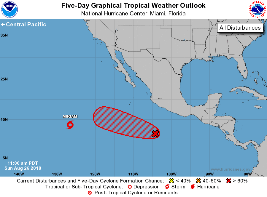
The second system of concern which is expected to be named Norman over time is well west of the Mexican coast. According to the National Hurricane Center, a broad area of low pressure located about 500 miles south of Manzanillo, Mexico, continues to produce a large area of cloudiness and disorganized showers and thunderstorms. Environmental conditions are expected to be conducive for the development of this disturbance over the next several days, and a tropical depression is likely to form by the middle of the week while the system moves westward to west-northwestward at 10 mph. The National Hurricane Center believes there’s 60% chance of cyclone formation over the next 48 hours and 90% chance of cyclone formation over the next five days. As with Miriam, it is too early to know what, if any, impacts this storm would have on Hawaii. Some model guidance has suggested this system could impact Hawaii in early September, but confidence in such guidance is low this far out.
With Hurricane Lane impacting people’s supply stocks, it is important that people re-stock their hurricane supplies in Lane’s wake should any of these other systems impact Hawaii. The hurricane season peaks in early September and it is very possible that more tropical cyclones beyond Hector and Lane will impact Hawaii this year.
