
An unsettled weather pattern will persist across the northeast, bringing more snowy conditions to a region that just saw a tremendous amount of snow from the Blizzard of 2017.
A potent upper-level trough is forecast to lift out of the eastern US early Friday as upstream energy digs south and east into the Ohio Valley by Friday night. This strong but progressive system will reach the coastal area late Friday night into Saturday, setting off another round of precipitation. Specifically, a warm front will lift northeast into the northern Mid Atlantic Friday night, bringing increasing warm air advection and isentropic lift. While the air mass will be moderating temperature-wise ahead of this atmospheric element, there should be enough cold air with this lift to produce some wintry precipitation. The air mass is initially very dry; because it is so dry, the first shot of precipitation from this warm advection shouldn’t reach the coastal region until late Friday night into Saturday.
As precipitation blossoms in the northeast, light snow is expected to break-out, especially over southeastern New England. Further south, conditions will be mild enough for only plain rain in places like Washington, DC and Baltimore. In between these regions, as it was with the Blizzard of 2017 earlier in the week, the forecast is much more complex. Temperatures at the surface and just above the surface will marginally support snow; sleet and/or freezing rain may be other precipitation types that fall instead of snow or rain. While confidence is high that this storm system will impact the region, confidence remains low in the precipitation types across eastern Pennsylvania, New Jersey, and New York.
The surface low from this system may track farther south and intensify south of Long Island on Saturday and south east of New England on Sunday. As the system heads off the coast, cold air may filter in on the back side of the precipitation changing any mixed or non-snow precipitation in places like New York City, Philadelphia, and New Jersey back over to a period of plain light snow. Some moisture from the system can also hang back on Saturday and Saturday night, resulting in a period of snow showers –much like what fell across the region on Wednesday with limited accumulations.
By Sunday afternoon, the low pressure system is forecast to move away from the northeastern United States. The pressure gradient between that departing low and an arriving high will tighten, leading to some breezy conditions on Sunday. That fair high pressure system will build further into the region on Monday, providing fair weather and relaxing winds then.
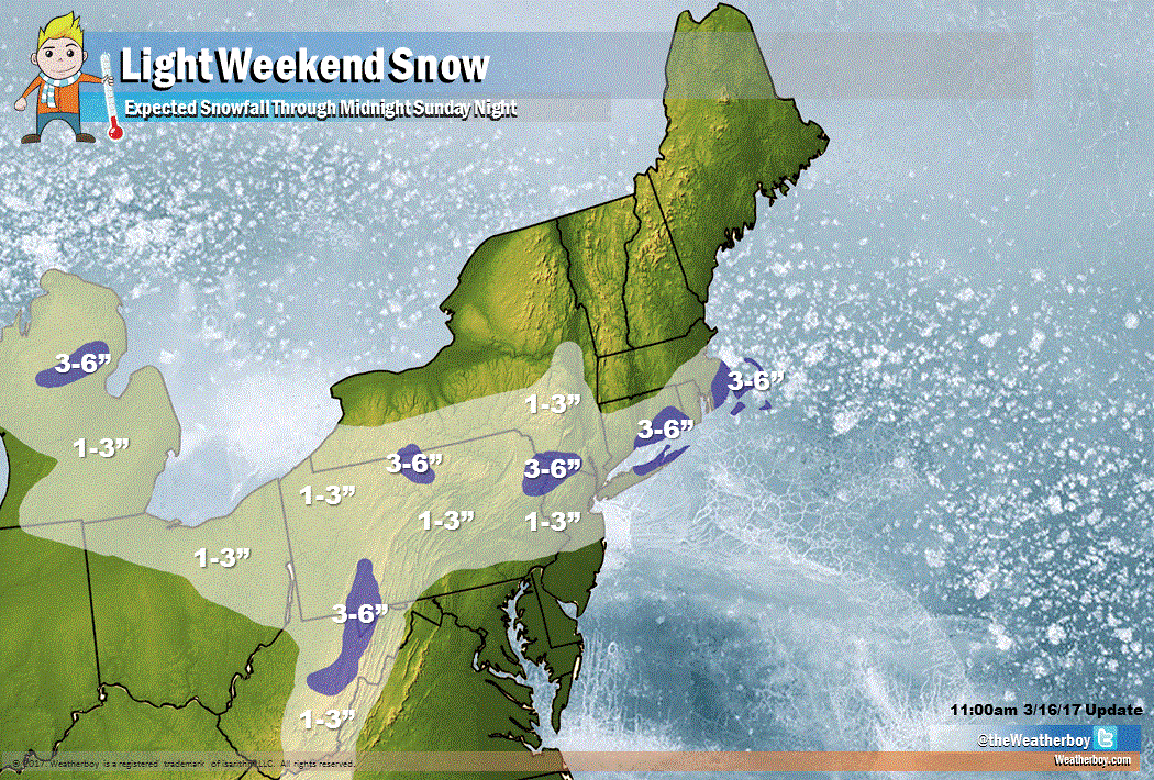
There are some computer forecast models that meteorologists use to aid in their forecasting that is suggesting a slower, stronger system which could bring heavier snow than expected. Because the weather pattern is becoming progressive, these solutions are being discounted for now. It is important to stress that confidence is low with expected snow amounts across portions of southern and eastern Pennsylvania, central and southern New Jersey, the New York City metro area, and southern New England; here, snowfall accumulations may increase or decrease depending on final storm track and intensity. While confidence is low, the current forecast calls for a widespread area of 1-3″ snow with some pockets of heavier 3-6″ amounts. Unlike the Blizzard of 2017, Cape Cod, Nantucket, and Martha’s Vineyard are expected to see much more snow with more moisture and cold air to work with this time around.
