Violent weather is impacting the nation today, with a rough 24-72 hours expected for some. The calendar says it’s the middle of January, but the eastern United States is dealing with weather situations more common in spring and fall while southern California is bracing for impact from an unusually potent storm there.
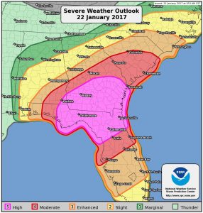
The National Weather Service’s Storm Prediction Center has made the unusual step of declaring a region in southern Georgia and northern Florida a “HIGH RISK” zone for severe weather today. The last time the Storm Prediction Center was able to declare a high-risk zone was June 3, 2014. This is coming on the heels of another rare severe event; a Particularly Dangerous Tornado Watch was issued last night, the first time such a watch was issued in January since January 22, 2012. Within this high-risk zone, there is a high probability of numerous large tornadoes; these tornadoes can also have very long tracks and bring destruction for miles and miles.
The storm system responsible for today’s severe weather in the southeast will create big headaches in the Mid Atlantic and Northeast. While severe thunderstorms and tornadoes are not expected there, damaging winds are. Winds could gust beyond tropical storm strength from Delaware north through the New York City metropolitan area and up into southeastern New England.
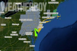
Because of the likelihood of damaging winds, the National Weather Service has issued a High Wind Warning for parts of New Jersey, New York, and Connecticut. The High Wind Warning is in effect from 3am tonight/early Monday morning through to 9pm Monday evening for Middlesex and Monmouth counties in New Jersey; it is in effect from 3am through 4pm tomorrow for Atlantic, Cape May, Atlantic, Ocean and Burlington Counties in New Jersey; it is in effect from 1am Monday through to 1am Tuesday for the New York City area including Fairfield, New Haven, Middlesex, New London counties in Connecticut, Hudson, Essex, and Union counties in New Jersey, and Westchester, Manhattan, Bronx, Richmond (Staten Island), Kings (Brooklyn), Suffolk, Queens, and Nassau Counties in New York.
A High Wind Warning means winds will be sustained at 30-40mph with gusts up to 60mph. Damaging winds will blow down trees and powerlines and numerous power outages are expected. Travel will be difficult, especially for high profile vehicles.
The National Weather Service has also issued a Wind Advisory further inland, including for the metro Philadelphia area. The Wind Advisory is in effect from 6am to 4pm Monday for Gloucester, Camden, and northwestern Burlington counties in New Jersey and Delaware and Philadelphia counties in Pennsylvania. Here, winds of 25-30mph are expected with gusts up to 50mph. Strong winds even here will blow down limbs, trees, and power lines and isolated to scattered power outages are expected.
Just off-shore, winds will really be intense; a Hurricane Wind Warning is in effect for the waters just off-shore from New York City. The Hurricane Force Wind Warning is in effect from 1pm Monday to 1am Tuesday and includes Moriches Inlet, NY to Montauk Point, NY out 20 nautical miles; Fire Island Inlet, NY to Moriches Inlet, NY out 20 nautical miles; Sandy Hook, NJ to Fire Island Inlet, NY out 20 nautical miles. Winds will gust 40-50kts with gusts up to 70kts (81mph). Seas will be extremely rough with waves 17-22 feet. Boaters are urged to head to safe port, especially small craft which may not be able to survive such fierce conditions.
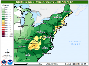
Very heavy rain is also coming to the eastern United States. More than 2″ of rain is possible across the New York City metro area into central coastal New Jersey. Heavy rain will also spread into southeastern Upstate New York, southern Connecticut, Rhode Island, and the rest of eastern New England. Rain is much needed in severe drought areas here; however, too much rain over a short period of time can lead to rapid run-off and flood problems. Remember: turn around, don’t drown! Never drive through flooded roadways.
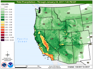
While it seems all the action is in the eastern US, that is not true today. California, especially southern California, will also be hit by a powerful storm coming on shore from the Pacific. There, more than 4″ of rain is possible in areas that usually don’t see much more than a tenth of an inch of rain at any given moment. While beneficial for the severe drought there, too much rain over a short period of time there will create widespread flooding problems.
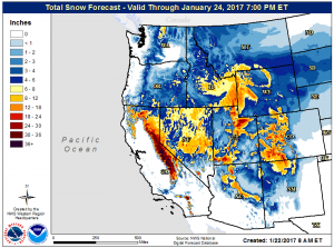
Rain will be the dominant precipitation type in the eastern United States, but the same won’t be true in the western United States. While cold air is absent from the east coast system, the west coast system has sufficient cold air to work with to produce very heavy snow. Portions of California may see another 3-6 feet of snow on top of 15 feet+ that has fallen just days ago.
The weather pattern is expected to undergo a significant change once these storms exit, with February beginning very different from how January is ending. More on that pattern change can be found here: https://weatherboy.com/significant-pattern-change-arriving-soon/
