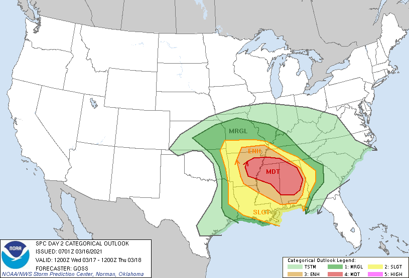
A storm system responsible for blizzard conditions around Denver and Boulder days ago will foster a violent weather outbreak tomorrow across portions of the southeast. The Wednesday severe weather event will include numerous hazards: the risk for large hail, damaging winds, and several strong tornadoes. The risk area for violent weather stretches from the Arkansas/Louisiana vicinity eastward across the central Gulf Coast states and southern Appalachian Mountains.
A compact, vigorous upper low located near Oklahoma is forecast to move east, spreading strong flow aloft and a broad zone of enhanced ascent across the south-central and into the southeastern continental U.S.. At the surface, a 998 mb low is forecast to advance eastward along a similar track, crossing northern Oklahoma and southern Kansas through the day, and then the Ozarks overnight. A trailing cold front will shift from eastern portions of the southern Plains and across Arkansas and Louisiana through the afternoon, and then across the Tennessee Valley and central Gulf Coast states through Wednesday night. Meanwhile, a warm front extending eastward from the low across northern Arkansas and southern Missouri and then east-southeastward across the Tennessee Valley into Georgia will linger in place on its eastern fringe, but will lift slowly northward in advance of the progressing low. These two fronts will outline a broad, moist, warm sector, which will gradually destabilize throughout the day supporting a widespread, significant severe weather event.
New storm development is expected to occur from the southwestern Missouri vicinity southward across the Arklatex region by early afternoon. Strong shear will support the ready evolution of rotating updrafts, with some long-lived storms likely evolving with time. Along with large hail potential, locally damaging winds will be possible, along with a steadily increasing tornado risk through the afternoon. According to the National Weather Service’s Storm Prediction Center, as storms move into central and eastern Arkansas, at least a few intense supercells are expected, within the broader area of storms. In a Convective Outlook update, the Storm Prediction Center says, “the potential for a couple of significant tornadoes is apparent, with this risk spreading into southwestern Tennessee and northern Mississippi with either pre-cold-frontal storms moving eastward into the region, or with other cells developing in a zone of increasing low-level warm advection in the warm sector/near the warm front.”
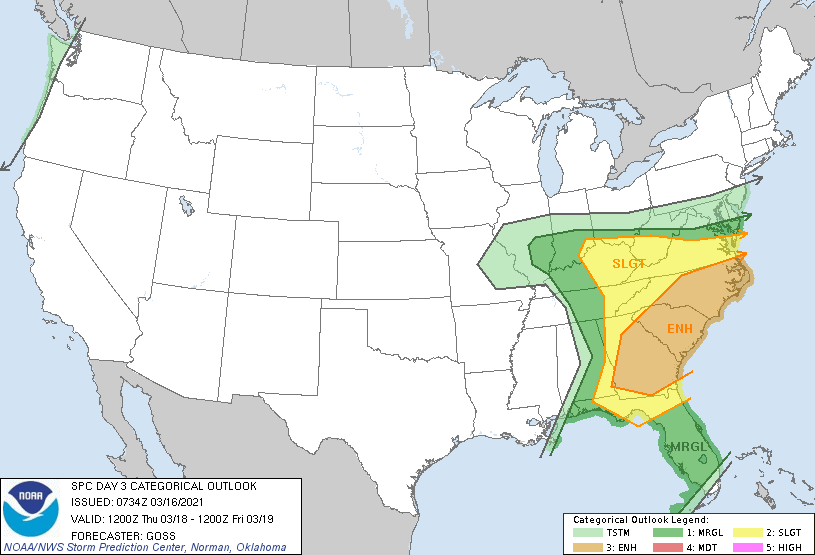
On Thursday, this severe weather threat area will shift east, with the greatest chance of severe storms over the Carolinas and Georgia. Thunderstorms are possible from central New Jersey and southern Pennsylvania and points south throughout Florida; however, the risk of severe weather should be south of northern Virginia and southern Maryland and Delaware.
