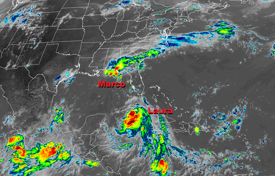
Fortunately for Louisiana, Hurricane Marco has gone through a weakening phase on its approach to the central Gulf coast, now impacting the region as a minimal tropical storm. However, the National Hurricane Center is urging people not to let their guard down here; Laura is expected to strengthen into a formidable hurricane and impact this region by Wednesday.
Tropical Storm Marco is located about 40 miles southeast of the mouth of the Mississippi River. Marco now has winds of only 40 mph and a minimum central pressure of 1008 mb or 29.77 inches. It is creeping along to the northwest at 6 mph.

All of the Tropical Storm Warnings and Storm Surge Warnings for the U.S. Gulf Coast have been discontinued. While there are no coastal watches or warnings in effect, gusty winds, heavy rainfall, and lingering coastal flooding are expected from Marco along portions of the Gulf Coast through this evening. There is even a slight risk of isolated tornadoes along the northeastern Gulf Coast through tonight.
While the advisories have been dropped for Marco, tropical cyclone wind and surge watches or warnings are likely to
be issued for portions of the U.S. Gulf Coast later today for Tropical Storm Laura which should be at hurricane strength when it impacts the coast.
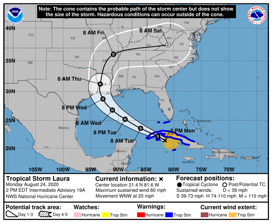
Meanwhile, Tropical Storm Laura is lashing Cuba with torrential rains and gusty winds. The center of Laura is passing near Cayo Largo, Cuba right now and is roughly 80 miles east of the Isle of Youth. Maximum sustained winds are 60 mph; it is moving to the west-northwest at 20 mph and has a minimum central pressure of 1001 mb or 29.56 inches.
For now, a Tropical Storm Warning is in effect for Little Cayman and Cayman Brac, the Cuban provinces of Camaguey, Las Tunas, Ciego De Avila, Sancti Spiritus, Villa Clara, Cienfuegos, Matanzas, Mayabeque, La Habana, Artemisa, Pinar del Rio, and the Isle of Youth, the Florida Keys from Craig Key to Key West, and for the Dry Tortugas. The Tropical Storm Warning means that tropical storm conditions are expected somewhere within the warning area, in this case within the next 12 hours.
On its current forecast track, the National Hurricane Center says Hurricane and Storm Surge Watches will likely be required for portions of the U.S. northwest Gulf coast area by this evening.
While Laura is moving to the west-northwest now, it should slow down a bit over the next day or two, with a turn more to the northwest forecast by Wednesday. On the forecast track, the center of Laura will move over the Caribbean Sea just offshore of the southern coast of Cuba this afternoon, cross western Cuba this evening, and move into the southeastern Gulf of Mexico overnight. Laura is then forecast to move over the central and northwestern Gulf of Mexico Tuesday night and Wednesday, and approach the northwestern coast of the Gulf of Mexico Wednesday night.
Because Laura will move over open water and won’t travel across Cuba’s highest peaks, strengthening is forecast in the coming days. While little change in strength is forecast today, strengthening is expected when the storm moves over the Gulf of Mexico. Laura is forecast to become a hurricane on Tuesday, with additional strengthening forecast on Wednesday. It is possible Laura could become a major hurricane with winds greater than 110 mph when it eventually strikes the U.S. coast.
Prior to arrival on the central Gulf Coast, Laura is expected to produce heavy rain, gusty winds, and isolated tornadoes today. Jamaica, Cuba and the Cayman Islands will get an additional 4-6″ of rain today, with some areas getting up to 10″. Across the Greater Antilles, this heavy rainfall could lead to life-threatening flash and urban flooding, and the potential for mudslides.
Tropical storm wind conditions are expected to spread westward within the warning area in Cuba through today. Tropical storm conditions are expected in Little Cayman and Cayman Brac today. Tropical storm conditions are also expected within the warning area in the middle and lower Florida Keys and the Dry Tortugas this afternoon and tonight. Isolated tornadoes will also be possible later today into tonight across the Florida Keys.
Seas are rough in Hurricane Marco’s wake and will still be rough with Laura’s approach. Even skilled surfers and swimmers are urged to avoid the Gulf of Mexico until threats from both storms have faded away.
