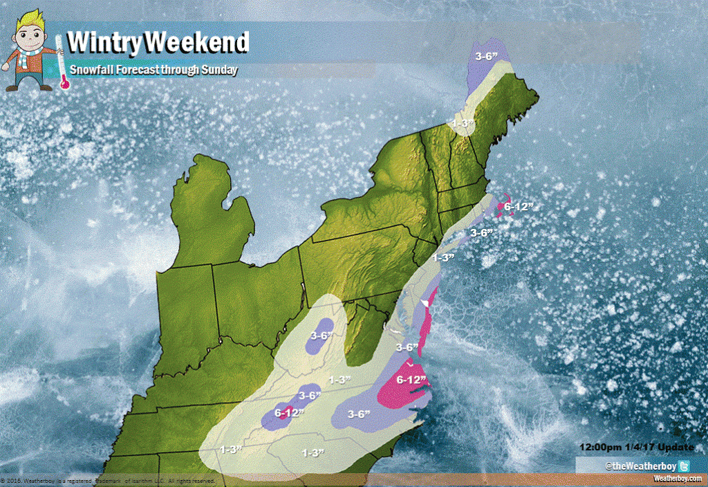
A series of weather systems will bring accumulating snow to portions of the East Coast this week.
The first system is moving through the extreme northeastern part of the US and southeastern Canada, responsible for some accumulating snow across northern New Hampshire and Maine. This system will put down an additional 1-3″ there, with 3-6″ more possible across the northern third of Maine.
The next system of interest is a relatively weak and fast moving storm which will bring portions of the northern Mid Atlantic some light snow late tomorrow into Friday. A system quickly on its heels will also swing through the east coast later Saturday into early Sunday, but that system will impact the southeast and extreme southeastern New England. It is these two systems that’ll produce the most snow now through Sunday, where upwards of 10″ may fall in some locations.
Right now, we believe most of the heavy snow will be confined to southeastern Virginia, northeastern North Carolina, the Atlantic coast of Maryland, southern Delaware, southern coastal New Jersey, eastern Long Island, and the Cape Cod region. Heavier snow is also possible over the higher terrain of central West Virginia and the higher terrain near the North Carolina / Tennessee border.
For the major cities in the northeast, these storms will mainly be a “miss.” From Washington, DC to Boston, most snow will fall south and east of the I-95 corridor. While some flakes are possible in Washington, DC and Boston, we expect accumulating snow to be limited to areas east or south of those cities. In New York and Philadelphia, a light dusting to an inch or two is possible.
Closer to the coast in New Jersey and out on central and eastern Long Island, more snow will fall. Here, 3-5 inches is expected for Hauppauge, Long Island and points east. We wouldn’t be surprised to see some amounts approach 6″ on the far eastern points of the Island. In New Jersey, a few inches of snow will fall from Point Pleasant Beach south to Cape May. Within this area of snow, some coastal communities from Brigantine to Cape May could see totals approaching 6-7″. Across Long Island and southern New Jersey, there may be a significant difference in snow totals over a short distance; as an example, in Burlington County, NJ, an inch or two could fall in the northwestern part of the county while 5-6″ could fall in the southeastern part of the county. Any slight jogs with the storm path and its related precipitation shield may shift snow amounts up/down accordingly; because the snow is falling over a very narrow strip of land, a shift of just a few miles could produce significant differences for coastal communities.
Further south, much of Delaware and eastern Maryland will see their first snowfall of the season. The greatest amounts will fall along the immediate Atlantic coast, with higher amounts south of Lewes, DE extending south to near Wallops Island, Virginia. Places like Ocean City, MD and Bethany Beach, MD may see 4-8″ of snow, with the greatest amounts right on the ocean with lighter amounts just inland.
The “jackpot zone” for this wintry weather event will be over southeastern Virginia and northeastern North Carolina, where a very significant 6-12″ is expected. A wide area of 3-6″ snows will also make travel tricky well inland from central North Carolina to points east. There’s also a “jackpot zone” near Cape Cod and surrounding islands in southeastern New England: we believe the primary storm system and a related “norlun trough” will provide additional snowfall there, which is why we have that area included in our 6-12″ range.
Light snow is also forecast for areas that usually don’t see much snow: northeastern Alabama, northern Georgia, and central and northern South Carolina. While only 1-3″ is forecast here, a light snow fall in areas that rarely see accumulating snow will create major travel problems this weekend.
Beyond this wintry stretch of days, the mid-range forecast isn’t looking great for snow-lovers. We discuss that more here: Bering Sea Rule in Action.